| Filename extension | .mif |
|---|---|
| Developed by | MapInfo |
| Type of format | GIS |
MapInfo Interchange Format is a map and database exporting/importing file format of MapInfo software product. The MIF-file filename usually ends with .mif-suffix. MIF-files usual have a related MID-file. The filename of a MID-file usually ends with .mid-suffix. If MID-file not exist, on import, MapInfo stores empty data to every data columns of created "Mapinfo Table".
MIF-file contains Block with the description of attributive Data-columns and Blocks that stores Geomentry Objects.
MID-file is CSV-like format to store the attributive Data. Each line in MID-file is related with the same order Geometry Block (Geometry Object) in MIF-file.

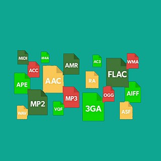
An audio file format is a file format for storing digital audio data on a computer system. The bit layout of the audio data is called the audio coding format and can be uncompressed, or compressed to reduce the file size, often using lossy compression. The data can be a raw bitstream in an audio coding format, but it is usually embedded in a container format or an audio data format with defined storage layer.
File Allocation Table (FAT) is a file system developed for personal computers and was the default filesystem for the MS-DOS and Windows 9x operating systems. Originally developed in 1977 for use on floppy disks, it was adapted for use on hard disks and other devices. The increase in disk drive capacity over time drove modifications to the design that resulted in versions: FAT12, FAT16, FAT32, and exFAT. FAT was replaced with NTFS as the default file system on Microsoft operating systems starting with Windows XP. Nevertheless, FAT continues to be commonly used on relatively small capacity solid-state storage technologies such as SD card, MultiMediaCard (MMC) and eMMC because of its compatibility and ease of implementation.
A world file is a six line plain text sidecar file used by geographic information systems (GIS) to georeference raster map images. The file specification was introduced by Esri.
Interchange File Format (IFF) is a generic digital container file format originally introduced by Electronic Arts in 1985 to facilitate transfer of data between software produced by different companies.

In computer science, a library is a collection of resources that is leveraged during software development to implement a computer program.
A filename extension, file name extension or file extension is a suffix to the name of a computer file. The extension indicates a characteristic of the file contents or its intended use. A filename extension is typically delimited from the rest of the filename with a full stop (period), but in some systems it is separated with spaces.
In computing, tar is a computer software utility for collecting many files into one archive file, often referred to as a tarball, for distribution or backup purposes. The name is derived from "tape archive", as it was originally developed to write data to sequential I/O devices with no file system of their own, such as devices that use magnetic tape. The archive data sets created by tar contain various file system parameters, such as name, timestamps, ownership, file-access permissions, and directory organization. POSIX abandoned tar in favor of pax, yet tar sees continued widespread use.
A GIS file format is a standard for encoding geographical information into a computer file, as a specialized type of file format for use in geographic information systems (GIS) and other geospatial applications. Since the 1970s, dozens of formats have been created based on various data models for various purposes. They have been created by government mapping agencies, GIS software vendors, standards bodies such as the Open Geospatial Consortium, informal user communities, and even individual developers.
The archiver, also known simply as ar, is a Unix utility that maintains groups of files as a single archive file. Today, ar is generally used only to create and update static library files that the link editor or linker uses and for generating .deb packages for the Debian family; it can be used to create archives for any purpose, but has been largely replaced by tar for purposes other than static libraries. An implementation of ar is included as one of the GNU Binutils.
On the Amiga, the Old File System was the filesystem for AmigaOS before the Amiga Fast File System. Even though it used 512-byte blocks, it reserved the first small portion of each block for metadata, leaving an actual data block capacity of 488 bytes per block. It wasn't very suitable for anything except floppy disks, and it was soon replaced.
OBJ is a geometry definition file format first developed by Wavefront Technologies for its Advanced Visualizer animation package. The file format is open and has been adopted by other 3D graphics application vendors.
MIF may refer to:

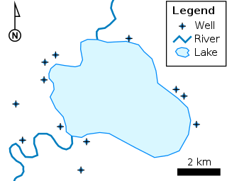
The shapefile format is a geospatial vector data format for geographic information system (GIS) software. It is developed and regulated by Esri as a mostly open specification for data interoperability among Esri and other GIS software products. The shapefile format can spatially describe vector features: points, lines, and polygons, representing, for example, water wells, rivers, and lakes. Each item usually has attributes that describe it, such as name or temperature.
In information and communications technology, a media type, content type or MIME type is a two-part identifier for file formats and content formats. Their purpose is comparable to filename extensions and uniform type identifiers, in that they identify the intended data format. They are mainly used by technologies underpinning the Internet, and also used on Linux desktop systems.
The MapInfo TAB format is a geospatial vector data format for geographic information systems software. It is developed and regulated by Precisely as a proprietary format.
This comparison of programming languages compares the features of language syntax (format) for over 50 computer programming languages.
A file format is a standard way that information is encoded for storage in a computer file. It specifies how bits are used to encode information in a digital storage medium. File formats may be either proprietary or free.
3DS is one of the file formats used by the Autodesk 3ds Max 3D modeling, animation and rendering software.
Additive manufacturing file format (AMF) is an open standard for describing objects for additive manufacturing processes such as 3D printing. The official ISO/ASTM 52915:2016 standard is an XML-based format designed to allow any computer-aided design software to describe the shape and composition of any 3D object to be fabricated on any 3D printer via a computer-aided manufacturing software. Unlike its predecessor STL format, AMF has native support for color, materials, lattices, and constellations.