
Ontonagon County is a county in the Upper Peninsula of the U.S. state of Michigan. As of the 2020 census, the population was 5,816, making it Michigan's third-least populous county. The county seat is Ontonagon. The county was set off in 1843, and organized in 1848. Its territory had been organized as part of Chippewa and Mackinac counties. With increasing population in the area, more counties were organized. After Ontonagon was organized, it was split to create Gogebic County. It is also the westernmost county in United States that lies within the Eastern Time Zone.

Houghton County is a county in the Upper Peninsula in the U.S. state of Michigan. As of the 2020 census, the population was 37,361. The county seat and largest city is Houghton. Both the county and the city were named for Michigan State geologist and Detroit Mayor Douglass Houghton.
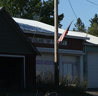
Greenland Township is a civil township of Ontonagon County in the U.S. state of Michigan. The population was 628 at the 2020 census.

Interior Township is a civil township of Ontonagon County in the U.S. state of Michigan. The population was 270 at the 2020 census. It was named for the Interior Lumber Company.

Ontonagon is a village in the Upper Peninsula of the U.S. state of Michigan. The population was 1,285 at the 2020 census. It is the county seat of Ontonagon County, and is the only incorporated place within the county.

Bergland is a census-designated place (CDP) and the primary community in Bergland Township, Ontonagon County, Michigan, United States. It is situated on the north shore of Lake Gogebic, the largest natural inland lake on the Upper Peninsula of Michigan. Highway M-28 passes through the center of town, leading east 19 miles (31 km) to Bruce Crossing and southwest 20 miles (32 km) to Wakefield. M-64 leads north from Bergland 17 miles (27 km) to the shore of Lake Superior and 30 miles (48 km) to Ontonagon, the county seat. Bergland is bordered to the west by the Lake Gogebic CDP.

M-28 is an east–west state trunkline highway that traverses nearly all of the Upper Peninsula of the U.S. state of Michigan, from Wakefield to near Sault Ste. Marie in Bruce Township. Along with US Highway 2 (US 2), M-28 forms a pair of primary highways linking the Upper Peninsula from end to end, providing a major access route for traffic from Michigan and Canada along the southern shore of Lake Superior. M-28 is the longest state trunkline in Michigan numbered with the "M-" prefix at 290.373 miles (467.310 km). The entire highway is listed on the National Highway System, while three sections of M-28 are part of the Lake Superior Circle Tour. M-28 also carries two memorial highway designations along its route.

The L'Anse Indian Reservation is the land base of the federally recognized Keweenaw Bay Indian Community of the historic Lake Superior Band of Chippewa Indians.. The reservation is located primarily in two non-contiguous sections on either side of the Keweenaw Bay in Baraga County in the Upper Peninsula of the U.S. state of Michigan. The Keweenaw Bay Community also manages the separate Ontonagon Indian Reservation.

Watersmeet is an unincorporated community and census-designated place (CDP) in Watersmeet Township, Michigan. As of the 2010 census, the CDP had a population of 428, out of a total population in the township of 1,417. The community was platted in 1884, designated as a station of the Milwaukee Lake Shore and Western Railroad.

M-38 is an east–west state trunkline highway in the Upper Peninsula (UP) of the U.S. state of Michigan. Its west end starts in Ontonagon and runs east to Baraga, some 42.225 miles (67.955 km) apart. The highway crosses streams and rivers in forest lands and provides access to a casino. The east end is located by the Keweenaw Bay of Lake Superior in the Keweenaw Bay Indian Community.
M-35 is a state trunkline highway in the Upper Peninsula (UP) of the US state of Michigan. It runs for 128 miles (206 km) in a general north–south direction and connects the cities of Menominee, Escanaba, and Negaunee. The southern section of M-35 in Menominee and Delta counties carries two additional designations; M-35 forms a segment of the Lake Michigan Circle Tour, and it is the UP Hidden Coast Recreational Heritage Trail, which is a part of what is now called the Pure Michigan Byways Program. Along the southern section, the highway is the closest trunkline to the Green Bay, a section of Lake Michigan. The northern section of the highway turns inland through sylvan areas of the UP, connecting rural portions of Delta and Marquette counties.
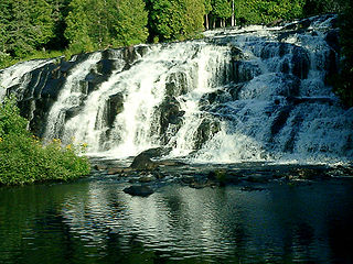
Bond Falls is a waterfall on the middle branch of the Ontonagon River, a few miles east of Paulding in Haight Township in southern Ontonagon County, Michigan. The site is near U.S. Highway 45 in the western portion of the Upper Peninsula of Michigan. The waterfalls are listed by the state of Michigan as the Bond Falls Scenic Site.
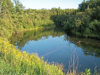
The Mineral River is an 18.7-mile-long (30.1 km) tributary of Lake Superior on the western Upper Peninsula of Michigan in the United States. It flows for its entire length in western Ontonagon County, rising in the Ottawa National Forest and flowing generally northward to meet Lake Superior about 11 miles (18 km) west-southwest of Ontonagon. The United States Board on Geographic Names settled on "Mineral River" as the stream's name in 1976; according to the Geographic Names Information System it has also been known historically as "Beaver Creek".

Lake Duluth was a proglacial lake that formed in the Lake Superior drainage basin as the Laurentide Ice Sheet retreated. The oldest existing shorelines were formed after retreat from the Greatlakean advance, sometime around 11,000 years B.P. Lake Duluth formed at the western end of the Lake Superior basin. Lake Duluth overflowed south through outlets in Minnesota and Wisconsin at an elevation of around 331 m above sea level.

The Ottawa National Forest is a national forest that covers 993,010 acres (401,860 ha) in the Upper Peninsula of the U.S. state of Michigan. It includes much of Gogebic and Ontonagon counties, as well as slices of Iron, Houghton, Baraga, and Marquette counties. The forest is under the jurisdiction of the U.S. Forest Service.
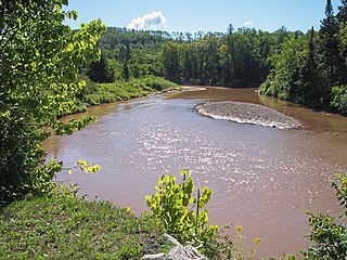
The Ontonagon River is a river flowing into Lake Superior at the village of Ontonagon, on the western Upper Peninsula of Michigan in the United States. The main stem of the river is 25 miles (40 km) long and is formed by a confluence of several longer branches, portions of which have been collectively designated as a National Wild and Scenic River. Several waterfalls occur on the river including Agate Falls and Bond Falls.

Lake Gogebic is the largest natural inland lake of the Upper Peninsula of Michigan. It is located within the one million acre (4,000 km2) Ottawa National Forest. Lake Gogebic State Park is located along its western shore.

The Agate Falls Scenic Site is a waterfall and scenic site located in Interior Township, in southeastern Ontonagon County, Michigan. The waterfall is 7 miles (11 km) southeast of Bruce Crossing, Michigan on the state highway M-28.
Greenland is an unincorporated community and census-designated place (CDP) in Greenland Township, Ontonagon County, Michigan, United States. It is 1 mile (1.6 km) north of Mass City. State highway M-38 forms the northern edge of the community, leading northwest 11 miles (18 km) to Ontonagon, the county seat, and east 30 miles (48 km) to Baraga.


