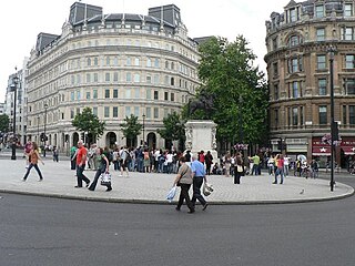
Charing Cross is a junction in London, England, where six routes meet. Clockwise from north these are: the east side of Trafalgar Square leading to St Martin's Place and then Charing Cross Road; the Strand; Northumberland Avenue; Whitehall; The Mall leading to Admiralty Arch and Buckingham Palace; and two short roads leading to Pall Mall.

Oxenhope is a village and civil parish near Keighley in the metropolitan borough of Bradford, West Yorkshire, England. The population was 2,476 at the time of the 2001 census which had increased to 2,626 at the 2011 Census. Historically part of the West Riding of Yorkshire, Oxenhope railway station is the terminus for the Keighley and Worth Valley Railway.

Romney Marsh is a sparsely populated wetland area in the counties of Kent and East Sussex in the south-east of England. It covers about 100 square miles (260 km2). The Marsh has been in use for centuries, though its inhabitants commonly suffered from malaria until the 18th century. Due to its location, geography, and isolation, it was a smuggler's paradise between the 1600s and 1800s. The area has long been used for sheep pasture; Romney Marsh sheep are considered one of the most successful and important sheep breeds. Criss-crossed with numerous waterways, and with some areas lying below sea level, the Marsh has over time sustained a gradual level of reclamation, both through natural causes and by human intervention.

Attenborough is a village in the Borough of Broxtowe in Nottinghamshire, England. It forms part of the Greater Nottingham area, and is 4 1⁄2 miles (7.2 km) to the southwest of the city of Nottingham, between Long Eaton and Beeston. It adjoins the suburbs of Toton to the west and Chilwell to the north. The population of the ward, as at the 2011 Census, was 2,328.

Bootle New Strand railway station is a railway station in the centre of Bootle, Merseyside, England. It is on the Northern Line of the Merseyrail network and serves in particular the nearby New Strand Shopping Centre. The platforms are elevated and are reached by ramps from the entrance at street level. Connecting bus services leave from the nearby bus station in the basement of New Strand Shopping Centre.
North Somercotes is a coastal village in the East Lindsey district, and the Marshes area, of Lincolnshire, England. The village is situated midway between the towns of Mablethorpe and Cleethorpes.

Moreton-in-Marsh railway station is a railway station serving the town of Moreton-in-Marsh in Gloucestershire, England. It is on the Cotswold Line between Kingham and Honeybourne stations. The station and all passenger trains serving it are operated by Great Western Railway.

Banks is a large coastal village in Lancashire, England, south of the Ribble estuary four miles (6 km) north-east of Southport. The village is administered by West Lancashire Borough and North Meols Parish Council. It is in the South Ribble parliamentary constituency. At the 2001 census, the population was 3,792.
Marsh Lane railway station can refer to:

Burgh le Marsh is a small town, and electoral ward in the East Lindsey district of Lincolnshire, England.

Malltraeth (origin: Mall is a small village in the southwest of Anglesey, in the community of Bodorgan. It is now at the end of a large bay, which used to extend much further inland, almost creating a second sea strait in the area. The population as of the 2011 census was only 255.
Hundred End railway station was on the West Lancashire Railway in England. It served the small community of Hundred End, so called because this was where the Leyland Hundred and West Derby Hundred met. It opened in 1878 and closed on 30 April 1962. Trains continued passing through the station until the line was closed in 1964
Marsh Lane railway station was built as the Leeds terminus of the Leeds and Selby Railway. The combined passenger and goods station opened in 1834.
Waddon Marsh railway station was in Waddon in the London Borough of Croydon on the West Croydon to Wimbledon Line. It was between West Croydon and Beddington Lane Halt stations. There was pedestrian access by footpath only from Miller Road a side street near Purley Way.
Edleston is a civil parish in the unitary authority of Cheshire East and the ceremonial county of Cheshire, England, which lies immediately to the south west of Nantwich. For administrative purposes, it is combined with adjacent civil parishes of Acton and Henhull to form a total area of 765 hectares. The parish is predominantly rural with scattered farms and houses, with the exception of a new housing estate at the eastern end of the parish east of the canal. Nearby villages include Acton and Ravensmoor.

National Cycle Route 1 is a route of the National Cycle Network, running from Dover to Shetland. The 2,769 km-long (1,721-mile) cycle-path is located in the United Kingdom.

Irby in the Marsh is a village and civil parish in the East Lindsey district of Lincolnshire, England. It is situated on the B1195 road, geographically 4.5 miles (7 km) east from Spilsby and 6 miles (10 km) west from Skegness.
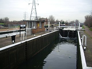
Stonebridge Lock (No16) is a paired lock on the River Lee Navigation in the London Borough of Haringey, England and is located near Tottenham, London. Like other locks as far as Ponder's End Lock it is large enough to take barges of up to 130 tons. The primary lock has been upgraded to mechanical operation, but the secondary lock is operated manually.
Tarlscough is a hamlet in the West Lancashire district, in the English county of Lancashire. It is roughly 1 3⁄4 miles (2.8 km) north of the centre of Burscough.

Barrow-in-Furness Strand railway station was the first permanent railway terminus to be built in Barrow-in-Furness, England. Located on the Strand at St. George's Square close to the town's docks its functioning life was short, however the building itself continued to be used as the headquarters of the Furness Railway for a number of years. The station opened in 1863 having replaced a wooden structure which was erected in 1846 at adjacent Rabbit Hill. The station at St. George's square ceased commercial operations in 1882 upon the completion of a new loop line and much larger station at Abbey Road. Barrow-in-Furness Central railway station, later simply renamed Barrow-in-Furness railway station has been the town's primary station ever since.