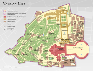
The geography of Vatican City is unique due to the country's position as an urban, landlocked enclave of Rome, Italy. With an area of 0.17 sq mi (0.44 km2), it is the world's smallest independent state. Outside the Vatican City, thirteen buildings in Rome and Castel Gandolfo enjoy extraterritorial rights. The country contains no major natural resources, and no known natural hazards other than those that affect Rome in general, such as earthquakes.

The Quirinal Hill is one of the Seven Hills of Rome, at the north-east of the city center. It is the location of the official residence of the Italian head of state, who resides in the Quirinal Palace; by metonymy "the Quirinal" has come to stand for the Italian president. The Quirinal Palace has an extension of 1.2 million square feet.

The Quirinal Palace is a historic building in Rome, Italy, one of the three current official residences of the President of the Italian Republic, together with Villa Rosebery in Naples and Tenuta di Castelporziano in Rome. It is located on the Quirinal Hill, the highest of the seven hills of Rome in an area colloquially called Monte Cavallo. It has housed thirty Popes, four Kings of Italy and twelve presidents of the Italian Republic.
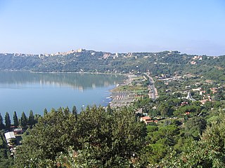
Castel Gandolfo is a town located 25 kilometres (16 mi) southeast of Rome in the Lazio region of Italy. Occupying a height on the Alban Hills overlooking Lake Albano, Castel Gandolfo has a population of approximately 8,900 residents and is considered one of Italy's most scenic towns.

Albano Laziale is a comune in the Metropolitan City of Rome, on the Alban Hills, in Latium, central Italy. Rome is 25 kilometres (16 mi) distant. It is bounded by other communes of Castel Gandolfo, Rocca di Papa, Ariccia and Ardea. Located in the Castelli Romani area of Lazio. It is sometimes known simply as Albano.
The Administrative subdivision of Rome refers to the first-level administrative subdivisions of the city of Rome, Italy. There are 15 municipalities in the city. Each municipality is governed by a president and a council who are elected directly by its residents every five years. The municipalites collectively comprise the comune of Rome, which is itself one of the constituent parts of the wider province known as the "Metropolitan City of Rome Capital".

Borgo, is the 14th historic district (rione) of Rome, Italy. It lies on the west bank of the Tiber, within Municipio I, and it has a trapezoidal shape. Its coat of arms shows a lion, lying in front of three mounts and a star. These - together with a lion rampant - are also part of the coat of arms of Pope Sixtus V, who annexed Borgo as the 14th rione of Rome.

Ludovisi is the XVI rione. Located within Municipio I, its coat of arms has three golden bands and a golden dragon, everything on a red background. It is the coat of arms of the noble Ludovisi family, which here owned the beautiful villa bearing the same name. The villa and the surrounding gardens, except for a single building, the Villa Aurora, were destroyed at the end of nineteenth century to build the new district.
Parioli is the 2nd quartiere of Rome, identified by the initials Q. II.

The Magliana is an urban zone of Rome, known as 15E of Municipio XI of Rome. It also the name of a neighborhood or ward of the city. Geographically, it is located on the South-West periphery of Rome, Italy along the Tiber River. The neighborhood dates back to the mid-1900s and is home to a diverse group of people of all ages and ethnicities. About 40,000 people reside in Magliana; housing is made up of mostly owner-occupied apartments in 7–8 story apartment buildings.

Palazzo Torlonia is a 16th-century Early Renaissance town house in Via della Conciliazione, Rome, Italy. Built for Cardinal Adriano Castellesi da Corneto from 1496, the architect was Andrea Bregno, although others have attributed the design to Bramante.
Settecamini or is an urban zone of Agro Romano, Rome. It also known for its serial number Z. VI.. Geographically, it is located in the east of the city near the Grande Raccordo Anulare and it borders the area of Guidonia Montecelio.

Via Nazionale is a street in Rome from Piazza della Repubblica leading towards Piazza Venezia.
Balduina, population 42,000, is an urban area that belongs to the Municipio XIX of the commune of Rome, and to the fourteenth borough of the city,. Situated at 139 metres above sea level on the southern side of Monte Mario, Balduina is the highest part of Rome.

Villa Sciarra is a park in Rome named for the villa at its centre. It is located between the neighborhoods of Trastevere, Gianicolo and Monteverde Vecchio.

Via Cristoforo Colombo is a street in Rome (Italy) that links the historic centre to Ostia. Along most of its route, the street has three lanes for each direction of movement. With its 27 kilometres (17 mi) length it is the longest Italian road among those included within the borders of a single municipality and, in several stretches, the largest in Italy.

Ostiense or Q. X Ostiense is a quarter of Rome in the south metropolitan area of Rome, Italy. it is part of Municipio VIII of Rome. Ostiense is also a namesake of an urban zone of Rome, a kind of smaller statistical and planning area, but with the serial 11A.
Casalotti is the name of the forty-eighth zone of Rome in the Agro Romano, denoted by Z. XLVIII. It is the namesake of the frazione of the same name.The area takes its name from the main road to Casalotti name, probably due to the numerous houses that were in the area.Surrounded by green hills, the center of the hamlet of Casalotti is situated at an altitude of about 110 m above sea level

The Villa dei Sette Bassi is an archaeological site located in Rome, Italy.

The following outline is provided as an overview of and topical guide to Rome:

