
The geography of Bolivia includes the Eastern Andes Mountain Range which bisects Bolivia roughly from north to south. To the east of that mountain chain are lowland plains of the Amazon Basin, and to the west is the Altiplano which is a highland plateau where Lake Titicaca is located. Bolivia's geography has features similar to those of Peru which abuts Bolivia's northwest border; like Bolivia, Peru is bisected from north to south by the Eastern Andes Mountains, and these two countries share Lake Titicaca which is the highest navigable lake on Earth. Unlike Peru, however, Bolivia is one of the two landlocked countries in South America, the other being Paraguay which is located along Bolivia's southeast border.

Lake Poopó is a large saline lake located in a shallow depression in the Altiplano Mountains in Oruro Department, Bolivia, at an altitude of approximately 3,700 m (12,100 ft). Because the lake was long and wide, it made up the eastern half of the department, known as a mining region in southwest Bolivia. The permanent part of the lake body covered approximately 1,000 square kilometres (390 sq mi) and it was the second-largest lake in the country. The lake received most of its water from the Desaguadero River, which flows from Lake Titicaca at the north end of the Altiplano. Since the lake lacked any major outlet and had a mean depth of less than 3 m (10 ft), the surface area differed greatly on a seasonal basis.

Ingavi is a province in the La Paz Department in Bolivia. This is where the Battle of Ingavi occurred on November 18, 1841 and where the World Heritage Site of Tiwanaku is situated.

Pacajes is a province in the Bolivian department of La Paz. Its capital is Coro Coro.
Desaguadero may refer to:

The Battle of Suipacha was fought on 7 November 1810 in Bolivia during the Bolivian War of Independence between the Spanish colonial army and the Republican forces sent by the Primera Junta from Buenos Aires. At the time Bolivia was known as Upper Peru. It was the first decisive defeat of the Royalists by Republican forces. The battle took place 25 km (16 mi) southeast of Tupiza, near the small town of Suipacha, on the margin of the Suipacha river in the Sud Chichas province.
The Lauca River is a binational river. It originates in the Chilean Altiplano of the Arica and Parinacota Region, crosses the Andes and empties into Coipasa Lake in Bolivia.

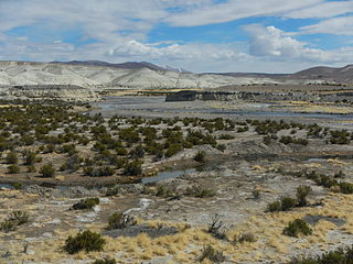
The Desaguadero River in Bolivia drains Lake Titicaca from the southern part of the river basin, flowing south and draining approximately five percent of the lake's flood waters into Lake Uru Uru and Lake Poopó. Its source in the north is very near the Peruvian border.
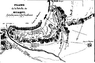
The Battle of Huaqui, was a battle between the Primera Junta's revolutionary troops and the royalist troops of the Viceroyalty of Peru on the border between Upper Peru,, and the Viceroyalty of Peru on June 20, 1811.

Desaguadero or Chaka Marka is a town on the Bolivian-Peruvian border. On the Bolivian side it is situated in the La Paz Department, Ingavi Province, Desaguadero Municipality, Desaguadero Canton. On the Peruvian side it lies in the Puno Region, Chucuito Province, Desaguadero District. Both parts of the town are united by a binational bridge.
Desaguadero Municipality is the fourth municipal section of Ingavi Province in La Paz Department, Bolivia. Its capital is Desaguadero.
The Qullpa Jawira is a river in the La Paz Department in Bolivia. It is a right affluent of the Desaguadero River.
The Ch'alla Jawira which upstream is named Ch'api K'uchu and downstream successively is called Tupa Jawira and Qura Jawira is a river in the La Paz Department in Bolivia. It is a right affluent of the Aqhuya Jawira whose waters flow to the Desaguadero River.
The Ch'alla Jawira which upstream successively is named Chilla Jawira, Pichini Jawira, Janq'u Quta and Siwinqa is a river in the La Paz Department in Bolivia. It is a left tributary of the Desaguadero River.
The Llallawa Jawira which upstream successively is named Patu Uma, Ch'alla Jawira, Jach'a Qura, Lupipi and Chuqi Phuju is a river in the La Paz Department in Bolivia. It is a left tributary of the Desaguadero River.
Canal Mauri is a canal in Peru and Chile. It transfers water from the Mauri River watershed and transfers it into the Caplina River for irrigation purposes. An earlier canal Canal Uchusuma was constructed in the early 19th century and was replaced by the Canal Mauri. This canal collects water from several tributaries of the Mauri River and diverts it through Chilean territory into the Quebrada Vilavilani, a tributary of the Caplina River; from there it is later diverted for irrigation purposes in the Tacna region.
Canal Uchusuma is a canal in Chile.


