
Jaipur Division is one of the administrative geographical unit, called a division, of Rajasthan state, India. The division comprises five districts, namely, Alwar, Dausa, Jaipur, Jhunjhunu, Sikar.

The Mara is an 8-kilometre (5 mi) Italian stream of Insubria, which runs through the Italian Province of Como and the Swiss Canton Ticino. It rises on the slopes of Monte Sighignola and enters Lake Lugano at Maroggia.

Kovno Governorate or Government of Kaunas was a governorate (guberniya) of the Russian Empire. Its capital was Kaunas. It was formed on 18 December 1842 by Tsar Nicholas I from the western part of Vilna Governorate, and the order was carried out on 1 July 1843. It was part of the Vilna Governorate-General and Northwestern Krai. The governorate included almost the entire Lithuanian region of Samogitia and the northern part of Aukštaitija.

Beclean is a commune in Brașov County, Romania. It is composed of five villages: Beclean, Boholț, Calbor, Hurez and Luța.
Negrilești is a commune located in Vrancea County, Romania. It is composed of a single village, Negrilești. Formerly part of Bârsești, it split off in 2003.

Bronka is a village in the administrative district of Gmina Brańsk, within Bielsk County, Podlaskie Voivodeship, in north-eastern Poland. It lies approximately 7 kilometres (4 mi) east of Brańsk, 19 km (12 mi) west of Bielsk Podlaski, and 44 km (27 mi) south of the regional capital Białystok.
Bzianka is a village in the administrative district of Gmina Rymanów, within Krosno County, Subcarpathian Voivodeship, in south-eastern Poland. It lies approximately 9 kilometres (6 mi) north-east of Rymanów, 15 km (9 mi) south-east of Krosno, and 45 km (28 mi) south of the regional capital Rzeszów.
Kamionka is a village in the administrative district of Gmina Borowie, within Garwolin County, Masovian Voivodeship, in east-central Poland. It lies approximately 2 kilometres (1 mi) south-west of Borowie, 9 km (6 mi) north-east of Garwolin, and 61 km (38 mi) south-east of Warsaw.
Pawłowo is a village in the administrative district of Gmina Winnica, within Pułtusk County, Masovian Voivodeship, in east-central Poland. It lies approximately 4 kilometres (2 mi) south of Winnica, 14 km (9 mi) south-west of Pułtusk, and 45 km (28 mi) north of Warsaw.
Bolmów is a village in the administrative district of Gmina Blizanów, within Kalisz County, Greater Poland Voivodeship, in west-central Poland. It lies approximately 4 kilometres (2 mi) north of Blizanów, 20 km (12 mi) north of Kalisz, and 92 km (57 mi) south-east of the regional capital Poznań.
Jarantów is a village in the administrative district of Gmina Blizanów, within Kalisz County, Greater Poland Voivodeship, in west-central Poland. It lies approximately 6 kilometres (4 mi) north-east of Blizanów, 20 km (12 mi) north of Kalisz, and 95 km (59 mi) south-east of the regional capital Poznań.
Lipe is a village in the administrative district of Gmina Blizanów, within Kalisz County, Greater Poland Voivodeship, in west-central Poland. It lies approximately 4 kilometres (2 mi) north of Blizanów, 20 km (12 mi) north of Kalisz, and 92 km (57 mi) south-east of the regional capital Poznań.
Maciejewo is a village in the administrative district of Gmina Osieczna, within Leszno County, Greater Poland Voivodeship, in west-central Poland. It lies approximately 6 kilometres (4 mi) north-east of Osieczna, 16 km (10 mi) north-east of Leszno, and 54 km (34 mi) south of the regional capital Poznań.
Radusz is a settlement in the administrative district of Gmina Międzychód, within Międzychód County, Greater Poland Voivodeship, in west-central Poland. It lies approximately 9 kilometres (6 mi) north-east of Międzychód and 73 km (45 mi) north-west of the regional capital Poznań.
Miedzianów is a village in the administrative district of Gmina Nowe Skalmierzyce, within Ostrów Wielkopolski County, Greater Poland Voivodeship, in west-central Poland. It lies approximately 7 kilometres (4 mi) north-west of Skalmierzyce, 20 km (12 mi) north-east of Ostrów Wielkopolski, and 101 km (63 mi) south-east of the regional capital Poznań.

Lądek is a village in Słupca County, Greater Poland Voivodeship, in west-central Poland. It is the seat of the gmina called Gmina Lądek. It lies approximately 11 kilometres (7 mi) south-east of Słupca and 73 km (45 mi) east of the regional capital Poznań.
Szymanowo is a village in the administrative district of Gmina Sorkwity, within Mrągowo County, Warmian-Masurian Voivodeship, in northern Poland. It lies approximately 10 kilometres (6 mi) north of Sorkwity, 14 km (9 mi) north-west of Mrągowo, and 45 km (28 mi) east of the regional capital Olsztyn.
Leśnica is a village in the administrative district of Gmina Małdyty, within Ostróda County, Warmian-Masurian Voivodeship, in northern Poland. It lies approximately 2 kilometres (1 mi) north of Małdyty, 30 km (19 mi) north-west of Ostróda, and 52 km (32 mi) west of the regional capital Olsztyn.
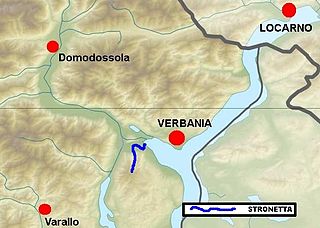
The Stronetta, or Rio Stronetta, is a small mountain torrent in the Province of Verbano Cusio Ossola, northern Italy.
The Fondo Toce or FondotoceNatural Reserve is a nature reserve established in 1990 in the Verbania municipality, which takes its name from the river Toce.
