
The National Road was the first major improved highway in the United States built by the federal government. Built between 1811 and 1837, the 620-mile (1,000 km) road connected the Potomac and Ohio Rivers and was a main transport path to the West for thousands of settlers. When improved in the 1830s, it became the second U.S. road surfaced with the macadam process pioneered by Scotsman John Loudon McAdam.

Ridgeley is a town in Mineral County, West Virginia, United States, and part of the Cumberland Metropolitan Statistical Area. The population was 590 at the 2020 census.
The Potomac Company was created in 1785 to make improvements to the Potomac River and improve its navigability for commerce. The project is perhaps the first conceptual seed planted in the minds of the new American capitalists in what became a flurry of transportation infrastructure projects, most privately funded, that drove wagon road turnpikes, navigations, and canals, and then as the technology developed, investment funds for railroads across the rough country of the Appalachian Mountains.

The Allegheny Mountain Range, informally the Alleghenies, is part of the vast Appalachian Mountain Range of the Eastern United States and Canada and posed a significant barrier to land travel in less developed eras. The Allegheny Mountains have a northeast–southwest orientation, running for about 300 miles (480 km) from north-central Pennsylvania southward, through western Maryland and eastern West Virginia.
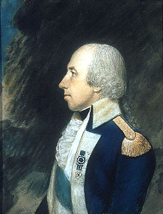
Rufus Putnam was an American military officer who fought during the French and Indian War and the American Revolutionary War. As an organizer of the Ohio Company of Associates, he was instrumental in the initial colonization by the United States of former Native American, English, and French lands in the Northwest Territory in present-day Ohio following the war.

Christopher Gist (1706–1759) was an explorer, surveyor, and frontiersman active in Colonial America. He was one of the first white explorers of the Ohio Country. Gist is credited with providing the first detailed description of the Ohio Country to colonists in the Thirteen Colonies. At the outbreak of the French and Indian War, Gist accompanied Colonel George Washington on missions into this wilderness and saved Washington's life on two occasions.
Peter Jefferson was a planter, cartographer and politician in colonial Virginia best known for being the father of the third president of the United States, Thomas Jefferson. The "Fry-Jefferson Map", created by Peter in collaboration with Joshua Fry in 1757, accurately charted the Allegheny Mountains for the first time and showed the route of "The Great Road from the Yadkin River through Virginia to Philadelphia distant 455 Miles"—what would later come to be known as the Great Wagon Road. Likewise, it indicates the route of the Trading Path from Petersburg to Old Hawfields, North Carolina and beyond.
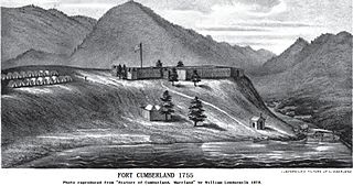
Fort Cumberland was an 18th-century frontier fort at the current site of Cumberland, Maryland, USA. It was an important military and economic center during the French and Indian War (1754–63) and figured significantly in the early career of George Washington.

Fairfax Stone Historical Monument State Park is a West Virginia state park commemorating the Fairfax Stone, a surveyor's marker and boundary stone at the source of the North Branch of the Potomac River. The original stone was placed on October 23, 1746 to settle a boundary dispute between Thomas Fairfax, 6th Lord Fairfax of Cameron and the Privy Council of Great Britain concerning the Northern Neck of Virginia. It determined the proprietorship and boundaries of a large tract of mostly unsurveyed land in the British colonies of Maryland and Virginia.

James Craik was Physician General of the United States Army, as well as George Washington's personal physician and close friend.
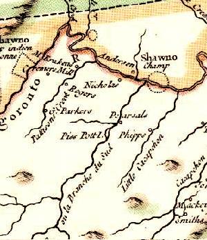
Piss Pot Island is an island on the South Branch Potomac River west of Romney in Hampshire County, West Virginia. It first appeared on Joshua Fry and Peter Jefferson's map of Virginia and Maryland in 1751.
The Great Wagon Road is a historic trail in the eastern United States that was first traveled by indigenous tribes, and later explorers, settlers, soldiers, and travelers. It extended from British Pennsylvania to North Carolina, through the Great Appalachian Valley, and from there to Georgia.
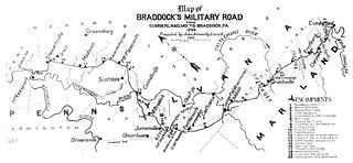
Nemacolin's Trail, or less often Nemacolin's Path, was an ancient Native American trail that crossed the great barrier of the Allegheny Mountains via the Cumberland Narrows Mountain pass, connecting the watersheds of the Potomac River and the Monongahela River in the present-day United States of America. Nemacolin's Trail connected what are now Cumberland, Maryland and Brownsville, Pennsylvania.
Colonel Joshua Fry (1699–1754) was an English-born American adventurer who became a professor, then real estate investor and local official in the colony of Virginia. Although he served several terms in the House of Burgesses, he may be best known as a surveyor and cartographer who collaborated with Peter Jefferson, the father of future U.S. president Thomas Jefferson. After Fry’s death on a military expedition, George Washington became commanding officer of the Virginia Regiment, a key unit in what became the French and Indian War.
Streets Run is a 5.2-mile-long (8.4 km) tributary of the Monongahela River in Allegheny County, Pennsylvania. This urban stream drains portions of the communities of Pittsburgh, Baldwin, Brentwood, West Mifflin and Whitehall, an area of about ten square miles.

Potts Creek is a 46-mile-long (74 km) tributary of the Jackson River in western Virginia. Via the Jackson River, it is part of the James River watershed, flowing to Chesapeake Bay. The creek rises in Monroe County, West Virginia, south of Waiteville, and flows northeast through Craig County and Alleghany County in Virginia, joining the Jackson River at Covington.

Carpenter Creek in western Virginia, now known as Potts Creek, was shown on a map of the area drawn by Joshua Fry and Peter Jefferson in 1751 and printed in 1755, and so called in the text of Thomas Jefferson's "Notes on the State of Virginia" that he prepared in the 1780s. Carpenter's Creek is also shown as such on John Ballendine's map of the James River published c1772 and Thomas Hutchins' map of the western regions of Virginia published in 1778.
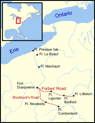
The Forbes Road, a historic military roadway in what was then British America, was initially completed in 1758 from Carlisle, Pennsylvania, to the French Fort Duquesne at the junction of the Allegheny and Monongahela rivers in what is now downtown Pittsburgh, via Fort Loudon, Fort Lyttleton, Fort Bedford and Fort Ligonier. The road, initially about 220 miles long, was named for Brigadier General John Forbes, the commander of the 1758 British-led expedition that built the road during the French and Indian War. The Forbes Road and Braddock's Road were the two main land routes that the British cut west through the wilderness during the war. The task was complicated by the Appalachian Mountains' steep northeast-to-southwest ridges, a generally broken terrain between the ridges, heavy forestation, and numerous swamps and rivers.
John Peter Salling, born Johan Peter Saling and sometimes referred to as John Peter Salley, Sayling, Sallings, and Sallee, was a German explorer known for being among the first Europeans to visit parts of what is now Virginia, West Virginia and Kentucky. He was imprisoned by the French in New Orleans on charges of spying and escaped together with another prisoner, taking eight months to finally reach his home in Virginia. His detailed journal describing his journeys of exploration was lost twice, and each time Salling was able to reconstruct it from memory. Salling's journal was used as a source in the creation of early maps of Virginia and eastern North America.
Nemacolin was a hereditary chief of the Delaware Nation who helped Thomas Cresap widen a Native American path across the Allegheny Mountains to the Ohio River Valley.


