
McKay's
Location of McKay's in Newfoundland and Labrador
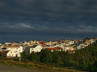
McKay's is a settlement in Newfoundland and Labrador. The settlement was first settled by Ann Hulan in the 1760s. Its population as of the 2011 census was 1,298. [1] [2]
McKay's is a settlement in Newfoundland and Labrador. The settlement was first settled by Ann Hulan in the 1760s. Its population as of the 2011 census was 1,298. [1] [2]

Newfoundland and Labrador is the easternmost province of Canada, in the country's Atlantic region. It is made up of the island of Newfoundland and the continental region of Labrador, having a total size of 405,212 square kilometres. The province's population was estimated to be 521,758 in 2021. The island of Newfoundland is home to around 94 per cent of the province's population, with more than half residing in the Avalon Peninsula.

Labrador is a geographic and cultural region within the Canadian province of Newfoundland and Labrador. It is the primarily continental portion of the province and constitutes 71% of the province's area but is home to only 6% of its population. It is separated from the island of Newfoundland by the Strait of Belle Isle. It is the largest and northernmost geographical region in the four Atlantic provinces.

St. John's is the capital and largest city of the Canadian province of Newfoundland and Labrador, located on the eastern tip of the Avalon Peninsula on the island of Newfoundland.
Paradise is a town on the Avalon Peninsula in the province of Newfoundland and Labrador, Canada. Paradise is the third largest settlement in the province and is part of the St. John's metropolitan area, the 20th largest metropolitan area in Canada. The town borders the City of St. John's, the City of Mount Pearl, the Town of Portugal Cove-St. Philip's, and the town of Conception Bay South. According to the 2021 census the population of Paradise was 22,957 an increase of 7.3% from its 2016 population total of 21,389.
Colliers is a town on the Avalon Peninsula in Newfoundland and Labrador, Canada. It is in Division 1 on Conception Bay.

Nunatsiavut is an autonomous area claimed by the Inuit in Newfoundland and Labrador, Canada. The settlement area includes territory in Labrador extending to the Quebec border. In 2002, the Labrador Inuit Association submitted a proposal for limited autonomy to the government of Newfoundland and Labrador. The constitution was ratified on December 1, 2005, at which time the Labrador Inuit Association ceased to exist, and the new Government of Nunatsiavut was established, initially being responsible for health, education and cultural affairs. It is also responsible for setting and conducting elections, the first of which was executed in October 2006. An election for the ordinary members of the Nunatsiavut Assembly was held on May 4, 2010. The Nunatsiavut Assembly was dissolved on April 6 in preparation for the election. Its incumbent president is Johannes Lampe who assumed office in 2016.

Nain is the northernmost permanent settlement in the Canadian province of Newfoundland and Labrador, within the Nunatsiavut region, located about 370 km (230 mi) by air from Happy Valley-Goose Bay. The town was established as a Moravian mission in 1771 by Jens Haven and other missionaries. As of 2021, the population is 1,204 mostly Inuit and mixed Inuit-European. Nain is the administrative capital of the autonomous region of Nunatsiavut.

Boyd's Cove, also known as Boyd's Harbour, is a local service district and designated place in the Canadian province of Newfoundland and Labrador that is near Lewisporte. There is an interpretive centre dedicated to the earlier indigenous Beothuk settlement at this location.

McCallum is a local service district and designated place in the Canadian province of Newfoundland and Labrador. It is on the southern coast of the island of Newfoundland. It is accessible only by boat or by air, and in appearance and way of life is thought by some to be as close to a pre-20th century community as may be found. McCallum lies in an enclosed harbour and is sheltered between two hills. The community survives primarily on the fishery. Whaling was also a major industry in the late 19th century. It is also about an hour and a half from the nearest road, in a community called Hermitage.
Calvert is a local service district and designated place in the Canadian province of Newfoundland and Labrador in the Southern Shore region of the province. It is 72 kilometres south of the provincial capital St. John's, 7 kilometres south of Cape Broyle, and 3 kilometres north of Ferryland. The population in 2001 was 355, a decline of 17% since 1996.

Petty Harbour–Maddox Cove is a town of approximately 960 people located on the eastern shore of the Avalon Peninsula in the province of Newfoundland and Labrador, Canada. It is nestled deep in the heart of Motion Bay, just south of St. John's. The present town is approximately 200 years old, though the site has been continuously occupied since at least 1598. It is one of the oldest European settlements in North America, predating the arrival of the Mayflower on the Massachusetts coast. During King William's War, the village was raided by French forces in the Avalon Peninsula Campaign.

Tilt Cove is a town located southeast of Baie Verte on Notre Dame Bay and was founded in 1813. With an official population of 5 at the 2021 census, Tilt Cove is known as "Canada's smallest town." A source of gold, copper, and zinc ores, Tilt Cove was the site of the first mine in Newfoundland. The Tilt Cove mine opened in 1864 and "was soon employing several hundred men at good wages". Postal service was established in 1869.

Pouch Cove is a town in the Canadian province of Newfoundland and Labrador. The population is 2,063 according to the Canada 2021 Census. It is located on the northeast Avalon Peninsula, 27 kilometres north of St. John's, the province's capital city.
Spanish Room is a local service district and designated place in the Canadian province of Newfoundland and Labrador.

Sop's Arm is a local service district and designated place in the Canadian province of Newfoundland and Labrador. The community was formed in the 1930s and 1940s by families moving from surrounding communities, including Jackson's Arm. In the 1950s and 1960s families from nearby Sop's Island moved to Sop's Arm, towing their houses across the channel of water.
Markland is a local service district and designated place in the Canadian province of Newfoundland and Labrador.

Newfoundland is a large island off the east coast of the North American mainland and the most populous part of the Canadian province of Newfoundland and Labrador. It has 29 percent of the province's land area. The island is separated from the Labrador Peninsula by the Strait of Belle Isle and from Cape Breton Island by the Cabot Strait. It blocks the mouth of the Saint Lawrence River, creating the Gulf of Saint Lawrence, the world's largest estuary. Newfoundland's nearest neighbour is the French overseas collectivity of Saint Pierre and Miquelon.

Newfoundland Colony was an English and, later, British colony established in 1610 on the island of Newfoundland off the Atlantic coast of Canada, in what is now the province of Newfoundland and Labrador. That followed decades of sporadic English settlement on the island, which was at first seasonal, rather than permanent. It was made a Crown colony in 1824 and a Dominion in 1907. Its economy collapsed during the Great Depression of the 1930s, and Newfoundland relinquished its dominion status, effectively becoming once again a colony governed by appointees from the Colonial Office in Whitehall in London. In 1949, the colony voted to join Canada as the Province of Newfoundland.
Lodge Bay is a local service district and designated place in the Canadian province of Newfoundland and Labrador. It is on the southeast coast of Labrador. Encompassing a population of less than one hundred residents, the community has uniquely evolved from both early European colonization of Labrador, and the inimitable patterns of land and resource use by the migratory Inuit population. The name Lodge Bay originated from the title Ranger Lodge, which was the name given to the area by trader and explorer, Captain George Cartwright in the late 18th century. "Ranger" was the name of the wooden-mercantile ship Cartwright used to trade, map and explore the Labrador coast, while "Lodge" was the name given to English hunting camps in Great Britain at that time.
Bay St. George South is a local service district and designated place in the Canadian province of Newfoundland and Labrador on the south coast of Bay St. George, a large bay on the west coast of the island of Newfoundland. Bay St. George South consists nine communities, namely Heatherton, Robinsons, Cartyville, McKay's, Jeffrey's, St. David's, St. Fintan's, Lock Leven en Highlands.
| | This Newfoundland and Labrador location article is a stub. You can help Wikipedia by expanding it. |