
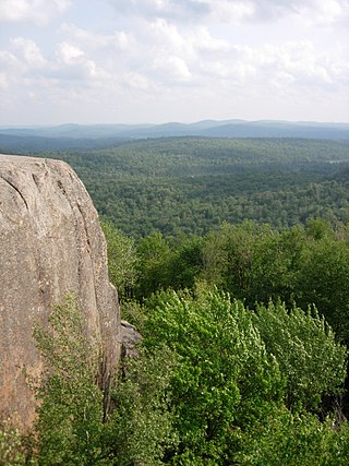
The Adirondack Mountains are a massif of mountains in Northeastern New York which form a circular dome approximately 160 miles (260 km) wide and covering about 5,000 square miles (13,000 km2). The region contains more than 100 peaks, including Mount Marcy, which is the highest point in New York at 5,344 feet (1,629 m). The Adirondack High Peaks, a traditional list of 46 peaks over 4,000 feet (1,200 m), are popular hiking destinations. There are over 200 named lakes with the number of smaller lakes, ponds, and other bodies of water reaching over 3,000. Among the named lakes around the mountains are Lake George, Lake Placid, and Lake Tear of the Clouds. The region has over 1,200 miles (1,900 km) of river.

The Adirondack Park is a park in northeastern New York protecting the Adirondack Mountains. The park was established in 1892 for "the free use of all the people for their health and pleasure", and for watershed protection. At 6.1 million acres, it is the largest park in the contiguous United States.

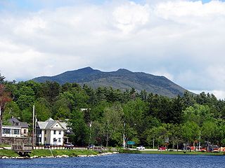
Whiteface Mountain is the fifth-highest mountain in the U.S. state of New York, and one of the High Peaks of the Adirondack Mountains, located in the town of Wilmington in Essex County. Set apart from most of the other High Peaks, the summit offers a 360-degree view of the Adirondacks and clear-day glimpses of Vermont and Canada, where Montreal can be seen on a very clear day. Because of its relative isolation, the mountain is exposed to prevailing winds from the west and frequently capped with snow and ice, making it an area of interest to meteorologists. Weather data has been collected on the summit since 1937. The mountain's east slope is home to a major ski area which boasts the greatest vertical drop east of the Rockies, and which hosted the alpine skiing competitions of the 1980 Winter Olympics. Unique among the High Peaks, Whiteface features a developed summit and seasonal accessibility by motor vehicle. The Whiteface Veterans Memorial Highway reaches a parking area at an elevation shortly below the summit, with the remaining distance covered by tunnel and elevator. The peak can also be reached on two hiking trails.
The Blue Ridge Wilderness Area, a unit of New York's Forest Preserve in the Adirondack Park, is located in the towns of Arietta, Lake Pleasant and Indian Lake in Hamilton County. It is roughly bounded on the north by NY 28; on the east by Route 28 and private lands immediately west of this route; on the south by private lands immediately north and west of Cedar River Flow; and on the west by the Lake Kora and Sagamore Lake properties and the South Inlet of Raquette Lake. It contains 19 bodies of water covering 275 acres and features 15 miles of foot trails and three lean-tos.

The Dix Mountain Wilderness Area is the name previously given to an area of New York's Forest Preserve in the Adirondack Park located in the towns of Elizabethtown, Keene and North Hudson, Essex County. It was roughly bounded on the north by NY 73, on the east by the Adirondack Northway (Interstate 87), on the south by Blue Ridge Road and on the west by Elk Lake Club and Ausable Club lands.
The Five Ponds Wilderness Area, an Adirondack Park unit of New York's Forest Preserve, is located in the towns of Fine and Clifton in St. Lawrence County, the town of Webb in Herkimer County and the town of Long Lake in Hamilton County. It includes 1,064 acres (4.3 km2) of private inholdings, 99 bodies of water covering 1,964 acres (7.9 km2), 57.9 miles (93.2 km) of trails, and 14 lean-tos.
The High Peaks Wilderness Area is the largest wilderness area of the Forest Preserve in the U.S. state of New York. It is located in three counties and six towns in the Adirondack Park: Harrietstown in Franklin County, North Elba, Keene, North Hudson and Newcomb in Essex County and Long Lake in Hamilton County.

The Ha-De-Ron-Dah Wilderness Area, an Adirondack Park unit of New York's Forest Preserve, is located in the town of Webb, Herkimer County, and the Town of Greig, Lewis County. It is bounded on the north by private lands in the vicinity of North Pond, Hitchcock Pond, Moose Pond and the headwaters of the Independence River; on the east by private lands along the Remsen to Lake Placid railroad right-of-way; on the south by private lands along New York State Route 28 and by the wood road leading to the Copper Lake property; and on the west by Pine Creek and a DEC maintained foot trail from Pine Creek to Pine Lake, East Pine Pond, and Big Otter Lake.
The Pigeon Lake Wilderness Area, an Adirondack Park unit of the forest preserve, lies in the town of Webb, Herkimer County, and the towns of Long Lake and Inlet in Hamilton County. It is bounded on the north by Stillwater Reservoir and large blocks of private land in the vicinity of Rose Pond, Shingle Shanty Pond and Upper Sister Lake; on the east by a private road from Brandreth Lake to North Point and by Raquette Lake; on the south by private lands along the Uncas Road; and on the west by the Big Moose Road, private lands near Big Moose Lake, Thirsty Pond, Twitchell Lake, Razorback Pond, and the Remsen to Lake Placid railroad tracks.
The Sentinel Range Wilderness Area, an Adirondack Park unit of New York's Forest Preserve, is located in the towns of Wilmington, North Elba and Keene, Essex County. It is bounded by NY 86 on the north, NY 73 on the south, and private lands on the east and west.
The Siamese Ponds Wilderness Area, an Adirondack Park unit of the Forest Preserve, is located in the towns of Lake Pleasant, Wells and Indian Lake in Hamilton County and the towns of Johnsburg and Thurman in Warren County. It is one of the larger wilderness areas of the Northeast; extending about 18 miles (29 km) from north to south and about 13 miles (21 km) from east to west at its widest part.
The Silver Lake Wilderness Area, an Adirondack Park unit of the Forest Preserve, is located in the towns of Lake Pleasant, Benson, Wells and Arietta in Hamilton County and is roughly bounded on the north by NY 8 and private lands near Piseco Lake, Oxbow Lake, Hamilton Lake, Sand Lake and Lake Pleasant; on the east by NY 30; on the south generally by the Hamilton County line; and on the west by NY 10, the West Branch of the Sacandaga River and the Piseco Outlet.
The West Canada Lake Wilderness Area is an Adirondack Park Forest Preserve management unit in the State of New York, USA.

Esther Mountain is a mountain located in Essex County, New York. The mountain is the northernmost of the High Peaks of the Adirondack Mountains and its 28th highest peak. It was the only High Peak named for a woman until 2014, having been named in honor of Esther McComb, who made the first recorded climb to the summit in 1839, at age 15; at the time she was attempting to climb Whiteface Mountain from the north.

Panther Peak is a mountain located in Essex County, New York. The mountain is part of the Santanoni Mountains of the Adirondacks. Panther Peak is flanked to the west by Couchsachraga Peak, and to the south by Santanoni Peak.
MacNaughton Mountain is a mountain located in Essex County, New York, named after James MacNaughton (1851–1905), the grandson of Archibald McIntyre. The mountain is part of the Street Range of the Adirondack Mountains.

The Saranac Lakes Wild Forest is a discontinuous 79,000-acre (320 km2) tract designated as Wild Forest by the New York State Department of Environmental Conservation in Franklin and Essex Counties near Saranac Lake, Tupper Lake, and Lake Placid. The area covers large portions of Harrietstown, Santa Clara, and North Elba; smaller portions are in Altamont, St. Armand, Brighton, and Franklin. The area is served by State Routes NY-3, NY-30, NY-86, and NY-73.

New York State Route 431 (NY 431) is a state highway in Essex County, New York, United States. The highway, also known as the Whiteface Mountain Veterans Memorial Highway, begins at an intersection with NY 86 in Wilmington and climbs Whiteface Mountain in the Adirondacks. The New York State Department of Environmental Conservation maintains the highway, which is 7.96 miles (12.81 km) long.
McKenzie Mountain is a 3,861-foot (1,177 m) mountain in western Essex County in the towns of St. Armand and North Elba in the Adirondack Park, a unit of the Forest Preserve.
