
The Helmandriver, also spelled Helmend, or Helmund, Hirmand, is the longest river in Afghanistan and the primary watershed for the endorheic Sistan Basin. It originates in the Sanglakh Range of the Hindu Kush mountains in the northeastern part of Maidan Wardak Province, where it is separated from the watershed of the Kabul River by the Unai Pass. The Helmand feeds into the Hamun Lake on the border of Afghanistan and Iran.

The Kokemäenjoki is a river in southwestern Finland.

Charlotte is the largest parish of Saint Vincent and the Grenadines, situated on the eastern coast of the island of Saint Vincent. With an area of 149 km², its size is comparable to that of the British Virgin Islands. It’s the country‘s largest parish by area and the second most populous one. The parish has the longest coastline of all the parishes and is also larger than the three smallest parishes combined. The parish possesses a very rough and rugged topography with very little flat land occurring towards the coast. as a result of these features, parts of the north of the parish cannot be accessed by a main road. Up until the building of a bridge over the Rabacca Dry River access to the north side of the river was not possible when rain caused the river to swell and make the path impassable.
Damastown is a townland in the civil parish of Mulhuddart in Fingal, Ireland, on the outskirts of Dublin. The townland is located west of the village of Mulhuddart and is north of the N3 road. A 1.8 km (1.1 mi) link road is nearing completion to link Damastown to the Cruiserath Road intersecting Church Road which links Mulhuddart to Tyrrelstown.
KTZN is a commercial radio station licensed to serve Anchorage, Alaska. The station is owned by iHeartMedia, Inc. Its studios are located at Dimond Center in Anchorage, and its transmitter is located off Dowling Road in Southeast Anchorage.

The Roseau River is one of the major rivers in Dominica. With a total length of 13.6 km (8.5 mi), it has a drainage basin area size of 33 km2 (13 sq mi).
Moose Jaw County was a provincial electoral division for the Legislative Assembly of the province of Saskatchewan, Canada. The district was created as "Moose Jaw" before the 1st Saskatchewan general election in 1905. The riding was abolished into the districts of Gravelbourg, Bengough, Notukeu-Willow Bunch, and Milestone before the 9th Saskatchewan general election in 1938. It was the constituency of Premier Charles Avery Dunning.

Calatayud is a Spanish Denominación de Origen Protegida (DOP) for wines located in the southwestern corner of the province of Zaragoza about 90 km from Zaragoza and covers over 5,600 ha, extending over 46 different municipalities, including Calatayud itself. It borders with the Cariñena (DO) in the east and with the province of Soria in the west. It is in the Ebro River valley and is crisscrossed by many of the Ebro's tributaries including the Jalón, Jiloca, Manubles, Mesa (river), Piedra and Ribota. The vineyards are found on the south facing slopes of the Sierra de la Virgen range at heights of between 550 m and 800 m above sea level.
Henik Lake is located in the Kivalliq Region of Nunavut, Canada. The lake is made up of two lakes, North Henik Lake and South Henik Lake with a narrows separating them. Of the two, North Henik Lake is the smaller with an area of 245 km2 (95 sq mi), while South Henik Lake has an area of 513 km2 (198 sq mi).

Pâ is a department or commune of Balé Province in southern Burkina Faso. Its capital is the town of Pâ. According to the 2019 census the department has a total population of 27,011.

The Continental IO-550 engine is a large family of 9 liter fuel injected six-cylinder, horizontally opposed, air-cooled aircraft engines that were developed for use in light aircraft by Teledyne Continental Motors. The first IO-550 was delivered in 1983 and the type remains in production.
The Canal River is a river on the Caribbean island of Dominica.
The Eden River is a river in Dominica.
The Lamoins River is a river in Dominica.
The Malabuka River is a river on the Caribbean island of Dominica.
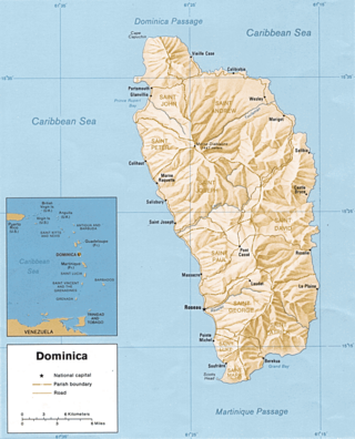
The Toulaman River is a river in Dominica. Its source is in the Morne Diablotins. It empties into the sea on the northeastern coast, north of Marigot.
The Richmond River is a river of Saint Vincent and the Grenadines.

Haccombe with Combe is a civil parish in the Teignbridge local government district of Devon, England. The parish lies immediately to the east of the town of Newton Abbot, and south of the estuary of the River Teign. Across the estuary are the parishes of Kingsteignton and Bishopsteignton. The parish is bordered on the east by Stokeinteignhead and on the south by Coffinswell. Most of the southern boundary of the parish follows the minor ridge road that runs between the suburbs of Milber in Newton Abbot and Barton in Torquay and it bisects the Iron Age hill fort of Milber Down.