Related Research Articles

The Mississippian, also known as Lower Carboniferous or Early Carboniferous, is a subperiod in the geologic timescale or a subsystem of the geologic record. It is the earlier of two subperiods of the Carboniferous period lasting from roughly 358.9 to 323.2 million years ago. As with most other geochronologic units, the rock beds that define the Mississippian are well identified, but the exact start and end dates are uncertain by a few million years. The Mississippian is so named because rocks with this age are exposed in the Mississippi Valley.

The Permian Basin is a large sedimentary basin in the southwestern part of the United States. It is the highest producing oil field in the United States, producing an average of 4.2 million barrels of crude oil per day in 2019. This sedimentary basin is located in western Texas and southeastern New Mexico.
The Highland Rim is a geographic term for the area in Tennessee, North Alabama, and Kentucky which surrounds the Central Basin. Geologically, the Central Basin is a dome. The Highland Rim is a cuesta surrounding the basin, and the border where the difference in elevation is sharply pronounced is an escarpment.

The St. Louis Limestone is a large geologic formation covering a wide area of the midwest of the United States. It is named after an exposure at St. Louis, Missouri. It consists of sedimentary limestone with scattered chert beds, including the heavily chertified Lost River Chert Bed in the Horse Cave Member. It is exposed at the surface through western Kentucky and Middle Tennessee, including the city of Clarksville, Tennessee. The limestone deposit is Mississippian in age, in the Meramecian series, roughly 330-340 million years old.
The Ste. Genevieve Limestone is a geologic formation named for Ste. Genevieve, Missouri where it is exposed and was first described. It is a thick-bedded limestone that overlies the St. Louis Limestone. Both are Mississippian in age. The St. Louis Limestone is Meramecian and the Ste. Genevieve is the base of the Chesterian series.

The San Juan Basin is a geologic structural basin located near the Four Corners region of the Southwestern United States. The basin covers 7,500 square miles and resides in northwestern New Mexico, southwestern Colorado, and parts of Utah and Arizona. Specifically, the basin occupies space in the San Juan, Rio Arriba, Sandoval, and McKinley counties in New Mexico, and La Plata and Archuleta counties in Colorado. The basin extends roughly 100 miles (160 km) N-S and 90 miles (140 km) E-W.

The Madison Limestone is a thick sequence of mostly carbonate rocks of Mississippian age in the Rocky Mountain and Great Plains areas of the western United States. The rocks serve as an important aquifer as well as an oil reservoir in places. The Madison and its equivalent strata extend from the Black Hills of western South Dakota to western Montana and eastern Idaho, and from the Canada–United States border to western Colorado and the Grand Canyon of Arizona.

The geology of Kansas encompasses the geologic history and the presently exposed rock and soil. Rock that crops out in the US state of Kansas was formed during the Phanerozoic eon, which consists of three geologic eras: the Paleozoic, Mesozoic and Cenozoic. Paleozoic rocks at the surface in Kansas are primarily from the Mississippian, Pennsylvanian, and Permian periods.

The Surprise Canyon Formation is a geologic formation that consists of clastic and calcareous sedimentary rocks that fill paleovalleys and paleokarst of Late Mississippian (Serpukhovian) age in Grand Canyon. These strata outcrop as isolated, lens-shaped exposures of rocks that fill erosional valleys and locally karsted topography and caves developed in the top of the Redwall Limestone. The Surprise Canyon Formation and associated unconformities represent a significant period of geologic time between the deposition of the Redwall Limestone and the overlying Supai Group.
The Supai Group is a slope-forming section of red bed deposits found in the Colorado Plateau. The group was laid down during the Pennsylvanian to Lower Permian. Cliff-forming interbeds of sandstone are noticeable throughout the group. The Supai Group is especially exposed throughout the Grand Canyon in northwest Arizona, as well as local regions of southwest Utah, such as the Virgin River valley region. It occurs in Arizona at Chino Point, Sycamore Canyon, and famously at Sedona as parts of Oak Creek Canyon. In the Sedona region, it is overlain by the Hermit Formation, and the colorful Schnebly Hill Formation.

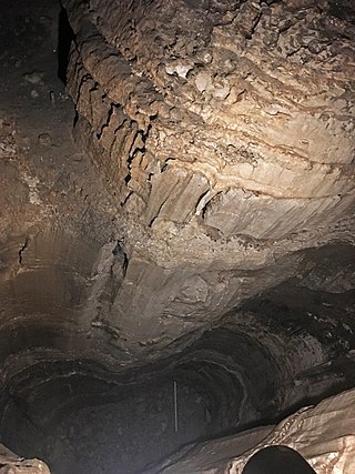
The Redwall Limestone is an erosion-resistant, Mississippian age, cliff-forming geological formation that forms prominent, red-stained cliffs in the Grand Canyon. these cliffs range in height from 150 m (490 ft) to 244 m (801 ft). It is one of the most fossiliferous formations exposed in the Grand Canyon region.

The Sandia Formation is a geologic formation in New Mexico, United States. Its fossil assemblage is characteristic of the early Pennsylvanian.

The Tererro Formation is a geologic formation in Sangre de Cristo Mountains of New Mexico. It preserves fossils dating back to the early Mississippian.

The Arroyo Penasco Group is a group of geological formations exposed in the Nacimiento, Jemez, Sandia, and Sangre de Cristo Mountains of northern New Mexico. It preserves fossils characteristic of the late Mississippian.
The geology of Ohio formed beginning more than one billion years ago in the Proterozoic eon of the Precambrian. The igneous and metamorphic crystalline basement rock is poorly understood except through deep boreholes and does not outcrop at the surface. The basement rock is divided between the Grenville Province and Superior Province. When the Grenville Province crust collided with Proto-North America, it launched the Grenville orogeny, a major mountain building event. The Grenville mountains eroded, filling in rift basins and Ohio was flooded and periodically exposed as dry land throughout the Paleozoic. In addition to marine carbonates such as limestone and dolomite, large deposits of shale and sandstone formed as subsequent mountain building events such as the Taconic orogeny and Acadian orogeny led to additional sediment deposition. Ohio transitioned to dryland conditions in the Pennsylvanian, forming large coal swamps and the region has been dryland ever since. Until the Pleistocene glaciations erased these features, the landscape was cut with deep stream valleys, which scoured away hundreds of meters of rock leaving little trace of geologic history in the Mesozoic and Cenozoic.
The geology of Kentucky formed beginning more than one billion years ago, in the Proterozoic eon of the Precambrian. The oldest igneous and metamorphic crystalline basement rock is part of the Grenville Province, a small continent that collided with the early North American continent. The beginning of the Paleozoic is poorly attested and the oldest rocks in Kentucky, outcropping at the surface, are from the Ordovician. Throughout the Paleozoic, shallow seas covered the area, depositing marine sedimentary rocks such as limestone, dolomite and shale, as well as large numbers of fossils. By the Mississippian and the Pennsylvanian, massive coal swamps formed and generated the two large coal fields and the oil and gas which have played an important role in the state's economy. With interludes of terrestrial conditions, shallow marine conditions persisted throughout the Mesozoic and well into the Cenozoic. Unlike neighboring states, Kentucky was not significantly impacted by the Pleistocene glaciations. The state has extensive natural resources, including coal, oil and gas, sand, clay, fluorspar, limestone, dolomite and gravel. Kentucky is unique as the first state to be fully geologically mapped.
The geology of Missouri includes deep Precambrian basement rocks formed within the last two billion years and overlain by thick sequences of marine sedimentary rocks, interspersed with igneous rocks by periods of volcanic activity. Missouri is a leading producer of lead from minerals formed in Paleozoic dolomite.

The geology of Wyoming includes some of the oldest Archean rocks in North America, overlain by thick marine and terrestrial sediments formed during the Paleozoic, Mesozoic and Cenozoic, including oil, gas and coal deposits. Throughout its geologic history, Wyoming has been uplifted several times during the formation of the Rocky Mountains, which produced complicated faulting that traps hydrocarbons.

The geology of North Dakota includes thick sequences oil and coal bearing sedimentary rocks formed in shallow seas in the Paleozoic and Mesozoic, as well as terrestrial deposits from the Cenozoic on top of ancient Precambrian crystalline basement rocks. The state has extensive oil and gas, sand and gravel, coal, groundwater and other natural resources.
The Molas Formation is a geologic formation that is found in the Four Corners region of the United States. Its age is poorly constrained but is thought to be Namurian.
References
| | This article about a specific stratigraphic formation in the United States is a stub. You can help Wikipedia by expanding it. |