Dutch commonly refers to:

Wyoming County is a county in the Commonwealth of Pennsylvania. It is part of Northeastern Pennsylvania. As of the 2020 census, the population was 26,069. Its county seat is Tunkhannock. It was created in 1842 from part of Luzerne County.

Meshoppen is a borough that is located in Wyoming County, Pennsylvania, United States. The population was 326 at the time of the 2020 census.
Meshoppen Township is a township in Wyoming County, Pennsylvania, United States. The population was 935 at the 2020 census.
Little Britain may refer to:
Pennsylvania Station is a name applied by the Pennsylvania Railroad to several of its grand passenger terminals.
Meshoppen Creek is a tributary of the Susquehanna River in Susquehanna and Wyoming counties, Pennsylvania, in the United States. It is approximately 30.6 miles (49.2 km) long and flows through Bridgewater Township, Dimock Township, and Springville Township in Susquehanna County and Lemon Township, Washington Township, Meshoppen Township, and Meshoppen in Wyoming County. The watershed of the creek has an area of 114 square miles (300 km2). It is possible to canoe on 17.0 miles (27.4 km) of Meshoppen Creek.

Conewago Creek is an 80.2-mile-long (129.1 km) tributary of the Susquehanna River in Adams and York counties in Pennsylvania in the United States, with its watershed also draining a small portion of Carroll County, Maryland. The source is at an elevation of 1,440 feet (440 m), east of Caledonia State Park, in Franklin Township in Adams County. The mouth is the confluence with the Susquehanna River at York Haven in York County at an elevation of 259 feet (79 m).

Pennsylvania Route 267 is a 30.78-mile-long (49.54 km) state highway located in Wyoming and Susquehanna counties in Pennsylvania. The southern terminus is at US 6 in Meshoppen. The northern terminus is the New York state line in Choconut Township.
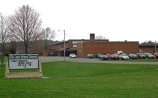
Elk Lake School District is a small, rural, K-12 public school district with its only building located on State Route 3019 in Dimock, Susquehanna County, Pennsylvania. It covers Auburn Township, Middletown Township, Rush Township, Dimock Township, and Springville Township in Susquehanna County, along with Meshoppen Borough and Meshoppen Township in Wyoming County. The Elk Lake School District encompasses approximately 197 square miles (510 km2). According to 2000 federal census data, Elk Lake School District serves a resident population of 7,735 people. In 2009, the district residents’ per capita income was $15,355, while the median family income was $38,385. In the Commonwealth, the median family income was $49,501 and the United States median family income was $49,445, in 2010. In 2006, the district students are 97% white, less than 1% Asian, less than 1% black and 2% Hispanic.
White Mill, White Mills and White's Mill may refer to:
The Old White Mill, also known as Sterling Mill and Pinnock Mill, is a historic grist mill located at Meshoppen, Wyoming County, Pennsylvania. It was built in 1852, and is a 5 1/2-story, banked frame structure. It measures 51 by 52 feet, sits on a stone foundation, and has a gable roof. It contains original milling equipment.

Sugar Hollow Creek is a tributary of Bowman Creek in Wyoming County, Pennsylvania, in the United States. It is approximately 4.7 miles (7.6 km) long and flows through Mehoopany Township and Eaton Township. The watershed of the creek has an area of 7.07 square miles (18.3 km2). The creek is not designated as an impaired waterbody. The surficial geology near its mouth consists of alluvium, Wisconsinan Outwash, and Wisconsinan Till. The creek is a High-Quality Coldwater Fishery, a Migratory Fishery, and Class A Wild Trout Waters.
Rogers Hollow is a tributary of Mehoopany Creek in Wyoming County, Pennsylvania, in the United States. It is approximately 2.2 miles (3.5 km) long and flows through Mehoopany Township. The watershed of the creek has an area of 2.44 square miles (6.3 km2). The creek is classified as a Coldwater Fishery and is in the vicinity of Mehoopany Mountain and Doll Mountain.

Blue Ridge Mountain is an isolated single peak in Wyoming County, Pennsylvania overlooking a loop of the Main Branch Susquehanna River in the sparsely settled Endless Mountains in Northeastern Pennsylvania a couple of miles west of Meshoppen at latitude, longitude coordinates: 41.6078537, -76.0929827 overlooking the northern end of the Wyoming Valley region. U.S. Route 6, a main east-west secondary highway and the railroad tracks built by the Lehigh Valley Railroad once followed by the famous Black Diamond Express named luxury trains on their daily runs from New York City to Buffalo, New York passes by its foot between the summit and the left bank (north) of the Susquehanna River.
Bowman Hollow is a tributary of Mehoopany Creek in Wyoming County, Pennsylvania, in the United States. It is approximately 2.2 miles (3.5 km) long and flows through Forkston Township. The watershed of the stream has an area of 3.08 square miles (8.0 km2). The stream flows over a highly secluded waterfall known as the Bowman Hollow Falls.
Mehoopany is an unincorporated community in Wyoming County, Pennsylvania, United States. The community is located along Pennsylvania Route 87, 3.6 miles (5.8 km) south of Meshoppen. Mehoopany has a post office with ZIP code 18629.
Little Meshoppen Creek is a tributary of Meshoppen Creek in Susquehanna County and Wyoming County, in Pennsylvania, in the United States. It is approximately 9.5 miles (15.3 km) long and flows through Auburn Township in Susquehanna County and Messhoppen Township and Messhoppen in Wyoming County. The watershed of the creek has an area of 13.8 square miles (36 km2). The creek is a Coldwater Fishery and Migratory Fishery and is not designated as an impaired waterbody. Numerous industries involved the creek in the 19th century, including a tannery, several mills, and a water company that constructed a dam on the creek.