
Bosnia and Herzegovina, abbreviated BiH or B&H, sometimes called Bosnia–Herzegovina and often known informally as Bosnia, is a country in South and Southeast Europe, located within the Balkans. Sarajevo is the capital and largest city.

Republika Srpska is one of the two entities of Bosnia and Herzegovina, the other being the Federation of Bosnia and Herzegovina. Its largest city and administrative centre is Banja Luka, lying on the Vrbas river.

The Herzegovina-Neretva Canton is one of 10 cantons of the Federation of Bosnia and Herzegovina in Bosnia and Herzegovina.

The Federation of Bosnia and Herzegovina is one of the two political entities that compose Bosnia and Herzegovina, the other being Republika Srpska. The Federation of Bosnia and Herzegovina consists of 10 autonomous cantons with their own governments. It is sometimes known by the shorter name Federation of B&H.

Tuzla is the third-largest city of Bosnia and Herzegovina and the administrative center of Tuzla Canton of the Federation of Bosnia and Herzegovina. As of 2013, it has a population of 110,979 inhabitants.
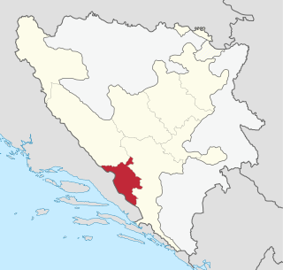
The West Herzegovina Canton is one of the cantons of the Federation of Bosnia and Herzegovina. In Croatian language, this canton is sometimes referred to as Županija Zapadnohercegovačka, but there is a significant difference between administrative units such as a županija compared to a canton, as defined in the Constitution of Bosnia and Herzegovina. The West Herzegovina Canton is in the Herzegovina region in the southwest of Bosnia and Herzegovina. Its seat of government is in Široki Brijeg, while other municipalities within the Canton are Grude, Ljubuški and Posušje. It has 94,898 inhabitants, of whom more than 98% are ethnic Croats.

Gradačac is a city located in Tuzla Canton of the Federation of Bosnia and Herzegovina, an entity of Bosnia and Herzegovina. It is situated in the northeastern part of Bosnia and Herzegovina, roughly 40 km (25 mi) south of the Sava river. As of 2013, it has a population of 41,836 inhabitants. The city is well known for its castle.

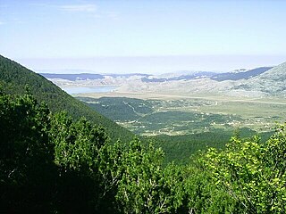
Pliva is a relatively small river in central parts of Bosnia and Herzegovina, however one of the most significant in terms of natural, cultural and historical heritage and value as a natural rarity. For hundreds of years this region was the ultimate stronghold of the Bosnian Kingdom, with the town of Jajce as permanent seat of the last kings of the Bosnian Kingdom.
Blidinje Nature Park is a nature park in Bosnia and Herzegovina, established on 30 April 1995. It is situated in the heart of Dinaric Alps and represent important natural, hydrogeological reservat in Dinaric karst of Bosnia and Herzegovina, with significant cultural and historical heritage. It consist of major mountains of Dinaric Alps range, plateau Dugopolje, Blidinje Lake, Grabovica valley and other characteristic karstic features.
The Drina is a 346 km (215 mi) long international river, which forms a large portion of the border between Bosnia and Herzegovina and Serbia. It is the longest tributary of the Sava River and the longest karst river in the Dinaric Alps which belongs to the Danube river watershed. Its name is derived from the Roman name of the river which in turn is derived from Greek.

Konjic is a town and municipality located in Herzegovina-Neretva Canton of the Federation of Bosnia and Herzegovina, an entity of Bosnia and Herzegovina. It is located in northern Herzegovina, around 60 kilometres (37 mi) southwest of Sarajevo. It is a mountainous, heavily wooded area, and is 268 m (879 ft) above sea level. The municipality extends on both sides of the Neretva River. As of 2013, it has a population of 26,381 inhabitants.

Herzegovina is the southern region of Bosnia and Herzegovina. It never had strictly defined geographical or cultural borders and it is not an administrative division in modern Bosnia and Herzegovina. It is generally taken to border larger Bosnia to the north, Dalmatia to the southwest and Montenegro to the southeast. Measurements of the area range widely from c. 11,500 km2 (4,400 sq mi), or around 23% of the total area of the present-day country, to c. 12,300 km2 (4,700 sq mi), around 25% of the country.

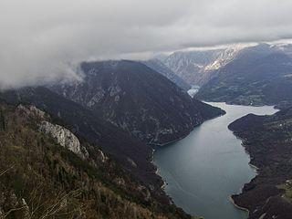
Bileća Lake is an artificial lake located in the municipality of Bileća, in the entity of Republika Srpska, Bosnia and Herzegovina, its length forming part of the Montenegrin border thus a small part being within Montenegro. The manmade lake was created by building the Grančarevo Dam an arch dam across the Trebišnjica River, which was built in 1968. It lies in the upper and central part of Trebsinjica valley, 17 km from Trebinje town and is one of the largest lakes in Bosnia and Herzegovina.
Grahovčići Lake is a part artificial, part natural lake of Bosnia and Herzegovina. It is located in the municipality of Travnik.
Pelagićevo Lake is a part artificial, part natural lake of Bosnia and Herzegovina. It is located in the municipality of Pelagićevo.

Vrtliško Lake is a part artificial, part natural lake of Bosnia and Herzegovina. It is located in the municipality of Kakanj.
Paučko Lake is part artificial, part natural lake of Bosnia and Herzegovina. It is located in the municipality of Kladanj.
Šićki Brod Lake is a part artificial, part natural lake of Bosnia and Herzegovina. It is located in the municipality of Šićki Brod.

Veliko Plivsko Lake is a part artificial, part natural lake of Bosnia and Herzegovina. It is located in the municipality of Jajce.