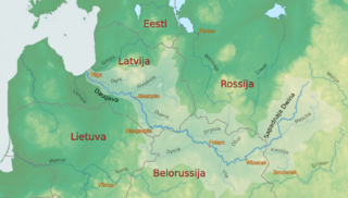
The Daugava or Western Dvina is a large river rising in the Valdai Hills of Russia that flows through Belarus and Latvia into the Gulf of Riga of the Baltic Sea. The Daugava rises close to the source of the Volga. It is 1,020 km (630 mi) in length, of which 352 km (219 mi) are in Latvia and 325 km (202 mi) in Russia. It is a westward-flowing river, tracing out a great south-bending curve as it passes through northern Belarus.

The Unzha is a river in the Vologda and Kostroma oblasts of Russia. It is a tributary of the Volga, which it enters at the Gorky Reservoir. It is 426 kilometres (265 mi) long, and its basin covers 27,800 square kilometres (10,700 sq mi). The Unzha begins at the confluence of the rivers Kema and the Lundonga. It flows into the Unzhensky Cove of the Gorky Reservoir.
Dubna is a town in Moscow Oblast, Russia.

The Mezha is a river in Nelidovsky, Zharkovsky, and Zapadnodvinsky Districts of Tver Oblast and Velizhsky District of Smolensk Oblast in Russia. It flows out of the Valdai Hills and continues west into the Daugava. The town of Nelidovo and the urban-type settlement of Zharkovsky are located along the Mezha. The Mezha is 259 kilometres (161 mi) long, and drains a basin of 9,080 square kilometres (3,510 sq mi). Its main tributaries are the Bereza, the Luchesa, the Obsha, and the Yelsha.
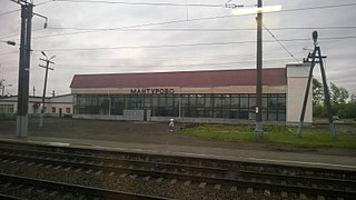
Manturovo is a town in Kostroma Oblast, Russia, located on the right bank of the Unzha River, 260 kilometers (160 mi) northeast of Kostroma, the administrative center of the oblast. Population: 13,043 (2021 Census); 17,479 (2010 Census); 19,457 (2002 Census); 22,452 (1989 Soviet census); 22,000 (1970).

The Kasplya is a river in Smolensky, Demidovsky, and Rudnyansky Districts of Smolensk Oblast of Russia and in Vitebsk Region of northern Belarus. It is a major left-bank tributary of the Daugava. Of its total length of 136 kilometres (85 mi), the first 116 kilometres (72 mi) are in Russia, and the rest in Belarus. It joins the Daugava in the urban-type settlement of Surazh. The town of Demidov is situated on the Kasplya.
The Obsha is a river in Sychyovsky District of Smolensk Oblast and Oleninsky, Belsky, and Zharkovsky Districts of Tver Oblasts, Russia. It is a left tributary of the Mezha. The Obsha is 153 kilometres (95 mi) long, and the area of its basin 2,080 square kilometres (800 sq mi). The town of Bely is located on the banks of the Obsha.

Macarius of the Yellow Water Lake and the Unzha, the Miracle Worker was a Russian Orthodox monk and saint. He is credited with the founding of four monasteries in the Middle and Upper Volga regions of Russia.
The Viga is a river in Kostroma Oblast in Russia, a right tributary of the Unzha. It is 175 kilometres (109 mi) long, and its basin covers 3,360 square kilometres (1,300 sq mi).

The Neya is a river in Kostroma Oblast, Russia. It is a tributary of the Unzha. It is 253 kilometers (157 mi) long, with a drainage basin of 6,060 square kilometers (2,340 sq mi).
Pustoshkinsky District is an administrative and municipal district (raion), one of the twenty-four in Pskov Oblast, Russia. It is located in the south of the oblast and borders with Bezhanitsky District in the north, Novosokolnichesky District in the east, Nevelsky District in the south, Sebezhsky District in the west, and with Opochetsky District in the northwest. The area of the district is 1,870 square kilometers (720 sq mi). Its administrative center is the town of Pustoshka. Population: 9,379 (2010 Census); 12,071 ; 14,063 (1989 Soviet census). The population of Pustoshka accounts for 49.2% of the district's total population.

Belsky District is an administrative and municipal district (raion), one of the thirty-six in Tver Oblast, Russia. It is located in the southwest of the oblast and borders with Nelidovsky District in the north, Oleninsky District in the northeast, Sychyovsky District of Smolensk Oblast in the east, Novoduginsky District of Smolensk Oblast in the southeast, Kholm-Zhirkovsky District of Smolensk Oblast in the south, Dukhovshchinsky District of Smolensk Oblast in the southwest, and with Zharkovsky District in the west. The area of the district is 2,135 square kilometers (824 sq mi). Its administrative center is the town of Bely. Population: 6,582 ; 8,125 (2002 Census); 10,005 (1989 Soviet census). The population of Bely accounts for 57.3% of the district's total population.
Oleninsky District is an administrative and municipal district (raion), one of the thirty-six in Tver Oblast, Russia. It is located in the southwest of the oblast and borders with Selizharovsky District in the north, Rzhevsky District in the east, Sychyovsky District of Smolensk Oblast in the southeast, Belsky District in the south, and with Nelidovsky District in the west. The area of the district is 2,675 square kilometers (1,033 sq mi). Its administrative center is the urban locality of Olenino. Population: 12,675 ; 14,817 (2002 Census); 18,892 (1989 Soviet census). The population of Olenino accounts for 38.8% of the district's total population.

Zapadnodvinsky District is an administrative and municipal district (raion), one of the thirty-six in Tver Oblast, Russia. It is located in the west of the oblast and borders with Toropetsky District in the north, Andreapolsky District in the northeast, Nelidovsky District in the east, Zharkovsky District in the southeast, Velizhsky District of Smolensk Oblast in the south, and with Kunyinsky District of Pskov Oblast in the west. The area of the district is 2,816 square kilometers (1,087 sq mi). Its administrative center is the town of Zapadnaya Dvina. Population: 16,018 ; 19,707 (2002 Census); 24,585 (1989 Soviet census). The population of Zapadnaya Dvina accounts for 58.6% of the district's total population.

Zharkovsky District is an administrative and municipal district (raion), one of the thirty-six in Tver Oblast, Russia. It is located in the southwest of the oblast and borders with Nelidovsky District in the north, Belsky District in the east, Dukhovshchinsky District of Smolensk Oblast in the southeast, Demidovsky District of Smolensk Oblast in the south, Velizhsky District of Smolensk Oblast in the southwest, and with Zapadnodvinsky District in the west. The area of the district is 1,625 square kilometers (627 sq mi). Its administrative center is the urban locality of Zharkovsky. Population: 6,132 ; 7,631 (2002 Census); 10,763 (1989 Soviet census). The population of the administrative center accounts for 65.5% of the district's total population.
Babushkinsky District is an administrative and municipal district (raion), one of the twenty-six in Vologda Oblast, Russia. It is located in the southeast of the oblast and borders with Nyuksensky District in the north, Kichmengsko-Gorodetsky District in the northeast, Nikolsky District in the east, Kologrivsky and Chukhlomsky Districts of Kostroma Oblast in the south, and with Totemsky District in the west. The area of the district is 7,761 square kilometers (2,997 sq mi). Its administrative center is the rural locality of imeni Babushkina. District's population: 12,779 (2010 Census); 14,994 ; 18,037 (1989 Soviet census). The population of imeni Babushkina accounts for 31.6% of the district's population.

Nikolsky District is an administrative and municipal district (raion), one of the twenty-six in Vologda Oblast, Russia. It is located in the southeast of the oblast and borders with Kichmengsko-Gorodetsky District in the north, Vokhomsky District of Kostroma Oblast in the east, Pavinsky, Pyshchugsky, Mezhevskoy, and Kologrivsky Districts of Kostroma Oblast in the south, Babushkinsky District in the southwest, and with Nyuksensky District in the west. The area of the district is 7,476 square kilometers (2,886 sq mi). Its administrative center is the town of Nikolsk. Population: 22,414 (2010 Census); 26,461 ; 31,437 (1989 Soviet census). The population of Nikolsk accounts for 38.0% of the district's total population.
Priklon is a rural locality in Danilovskoye Rural Settlement, Melenkovsky District, Vladimir Oblast, Russia. The population was 445 as of 2010. There are 6 streets.