
L'Anse is a village and the county seat of Baraga County, Michigan. The population was 1,874 at the 2020 census. The village is located within L'Anse Township in the Upper Peninsula, and partially inside the L'Anse Indian Reservation.
Athens Township is a civil township of southwest Calhoun County in the U.S. state of Michigan, about 15 miles (24 km) south of Battle Creek. It is part of the Battle Creek, Michigan Metropolitan Statistical Area. As of the 2020 census, the township population was 2,444. The Nottawaseppi Huron Band of Potawatomi is based in Athens Township.

Superior Township is a civil township of Chippewa County in the U.S. state of Michigan. The population was 1,276 at the 2020 census.
Nottawa Township is a civil township of St. Joseph County in the U.S. state of Michigan. The population was 3,685 at the 2020 census. The township is named after the Nottawaseppi Huron Band of Potawatomi.
A minor civil division (MCD) is a term used by the United States Census Bureau for primary governmental and/or administrative divisions of a county or county-equivalent, typically a municipal government such as a city, town, or civil township. MCDs are used for statistical purposes by the Census Bureau, and do not necessarily represent the primary form of local government. They range from non-governing geographical survey areas to municipalities with weak or strong powers of self-government. Some states with large unincorporated areas give substantial powers to counties; others have smaller or larger incorporated entities with governmental powers that are smaller than the MCD level chosen by the Census.
A township in some states of the United States is a small geographic area.
The Odawa are an Indigenous American people who primarily inhabit land in the Eastern Woodlands region, now in jurisdictions of the northeastern United States and southeastern Canada. Their territory long preceded the creation of the current border between the two countries in the 18th and 19th centuries.

The Ohio Lands were the several grants, tracts, districts and cessions which make up what is now the U.S. state of Ohio. The Ohio Country was one of the first settled parts of the Midwest, and indeed one of the first settled parts of the United States beyond the original Thirteen Colonies. The land that became first the anchor of the Northwest Territory and later Ohio was cobbled together from a variety of sources and owners.

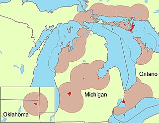
The L'Anse Indian Reservation is the land base of the federally recognized Keweenaw Bay Indian Community of the historic Lake Superior Band of Chippewa Indians.. The reservation is located primarily in two non-contiguous sections on either side of the Keweenaw Bay in Baraga County in the Upper Peninsula of the U.S. state of Michigan. The Keweenaw Bay Community also manages the separate Ontonagon Indian Reservation.

The Isabella Indian Reservation is the primary land base of the federally recognized Saginaw Chippewa Tribal Nation, located in Isabella County in the central part of the U.S. state of Michigan. The tribe also has some small parcels of off-reservation trust land in Standish Township, Arenac County, near Saginaw Bay and southeast of the city of Standish. Tribal lands are held in trust by the federal government on behalf of the nation.
The Menominee are a federally recognized tribe of Native Americans officially known as the Menominee Indian Tribe of Wisconsin. Their land base is the Menominee Indian Reservation in Wisconsin. Their historic territory originally included an estimated 10 million acres (40,000 km2) in present-day Wisconsin and the Upper Peninsula of Michigan. The tribe currently has about 8,700 members.

The Lac Courte Oreilles Tribe is one of six federally recognized bands of Ojibwe people located in present-day Wisconsin. It had 7,275 enrolled members as of 2010. The band is based at the Lac Courte Oreilles Indian Reservation in northwestern Wisconsin, which surrounds Lac Courte Oreilles. The main reservation's land is in west-central Sawyer County, but two small plots of off-reservation trust land are located in Rusk, Burnett, and Washburn counties. The reservation was established in 1854 by the second Treaty of La Pointe.

The Grand Traverse Band of Ottawa and Chippewa Indians is a federally recognized Native American tribe located in northwest Michigan on the Leelanau Peninsula. Sam McClellan is the current tribal chairman, elected in June 2016 to a four-year term after succeeding Al Pedwaydon, who served from 2012 to 2016.

The Nottawaseppi Huron Band of Potawatomi (NHBP) is a federally-recognized tribe of Potawatomi in the United States. The tribe achieved federal recognition on December 19, 1995, and currently has approximately 1500 members.

Lac Vieux Desert Band of Lake Superior Chippewa is a federally recognized band of the Lake Superior Chippewa, many of whom reside on the Lac Vieux Desert Indian Reservation, located near Watersmeet, Michigan. It is approximately 45 miles southeast of Ironwood, Michigan in Gogebic County.

The Little Traverse Bay Bands of Odawa Indians is a federally recognized Native American tribe of Odawa. A large percentage of the more than 4000 tribal members continue to reside within the tribe's traditional homelands on the northwestern shores of the state of Michigan's Lower Peninsula. The historically delineated reservation area, located at 45°21′12″N84°58′41″W, encompasses approximately 336 square miles (870 km2) of land in Charlevoix and Emmet counties. The largest communities within the reservation boundaries are Harbor Springs, where the tribal offices are located; Petoskey, where the Tribe operates the Odawa Casino Resort; and Charlevoix.

Keweenaw Bay is an arm of Lake Superior in North America. It is located adjacent to the Upper Peninsula of the U.S. state of Michigan, to the southeast of the Keweenaw Peninsula. Keweenaw Bay is 22 miles long and 12 miles wide at the mouth. The head of the bay sits within the reservation of the Keweenaw Bay Indian Community. It is also the name of a small community near the bay.
Nottawa Creek is a 33.9-mile-long (54.6 km) stream in the U.S. state of Michigan that flows into the St. Joseph River at 42°00′15″N85°23′40″W, approximately three miles east of the village of Mendon.

The Juneau Monument is a public artwork by American artist Richard Henry Park located on the grounds of Juneau Park, which is in Milwaukee, Wisconsin. The base of the statue is made of limestone. On top of the base is a bronze statue of Solomon Juneau. On each side of the base are bronze reliefs. The statue is 5 feet (1.5 m) wide by 15 feet (4.6 m) high.