Microregion of Seridó Oriental

Last updated
Seridó Oriental
Microregion
RioGrandedoNorte Micro SeridoOriental.svg
Country Brazil
State Rio Grande do Norte
Mesoregion Central Potiguar
Area
  Total 3,825.73 km2 (1,477.12 sq mi)

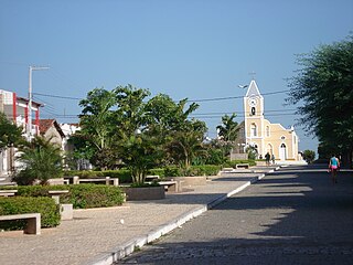
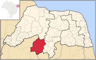
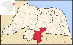
Seridó Oriental is a microregion in the Brazilian state of Rio Grande do Norte. It has a total area of 3,825.73 square kilometers (1,477.1 sq mi). [1]

Brazil Federal republic in South America

Brazil, officially the Federative Republic of Brazil, is the largest country in both South America and Latin America. At 8.5 million square kilometers and with over 208 million people, Brazil is the world's fifth-largest country by area and the fifth most populous. Its capital is Brasília, and its most populated city is São Paulo. The federation is composed of the union of the 26 states, the Federal District, and the 5,570 municipalities. It is the largest country to have Portuguese as an official language and the only one in the Americas; it is also one of the most multicultural and ethnically diverse nations, due to over a century of mass immigration from around the world.

Rio Grande do Norte State of Brazil

Rio Grande do Norte is one of the states of Brazil, located in the northeastern region of the country, occupying the northeasternmost tip of the South American continent. Because of its geographic position, Rio Grande do Norte has a strategic importance. The capital and largest city is Natal. It is the land of the folklorist Luís da Câmara Cascudo and, according to NASA, it has the purest air in the Americas. Its 410 km (254 mi) of sand, much sun, coconut palms and lagoons are responsible for the fame of beaches. Rocas Atoll, the only such feature in the Atlantic Ocean, is part of the state. The main economic activity is tourism, followed by the extraction of petroleum, agriculture, fruit growing and extraction of minerals, including considerable production of seasalt, among other economic activities. The state is famous for having many popular attractions such as the Cashew of Pirangi, the dunes and the dromedaries of Genipabu, the famous beaches of Ponta Negra, Maracajaú and Pipa's paradise, the Carnatal the largest off-season carnival in Brazil, the Forte dos Reis Magos is a sixteenth-century fortress, the hills and mountains of Martins, the Natal Dunes State Park the second largest urban park in the country, and several other attractions. The state is also closest to the archipelago of Fernando de Noronha.

Municipalities

The microregion consists of the following municipalities: [2]

Acari, Rio Grande do Norte Municipality in Nordeste, Brazil

Acari is a municipality in the state of Rio Grande do Norte in the Northeast region of Brazil.

Carnaúba dos Dantas Municipality in Nordeste, Brazil

Carnaúba dos Dantas is a municipality in the state of Rio Grande do Norte in the Northeast region of Brazil.

Cruzeta Municipality in Nordeste, Brazil

Cruzeta is a municipality in the state of Rio Grande do Norte in the Northeast region of Brazil.

Related Research Articles

Caicó Municipality in Nordeste, Brazil

Caicó, also known as the City of Prince, is a municipality in the Seridó Ocidental microrregion and Central Potiguar mesorregion, in Rio Grande do Norte state, Northeast Brazil. With a population of 62,709 inhabitants (2010), it is the seventh most populous city of Rio Grande do Norte and the second in the state, after Mossoró.

Piranhas River river in Brazil

The Piranhas River, also known as the Açu River, is a river of northeastern Brazil. It originates in southeastern Paraíba state, near the border with Ceará, and flows north-northeast through Paraíba and Rio Grande do Norte states to empty into the Atlantic Ocean near Macau. Its chief tributary is the Seridó, which originates in the Borborema Plateau of central Paraíba and flows northwest to meet the Piranhas.

The Seridó River is a tributary of the Piranhas River in northeastern Brazil. The Seridó originates in the Borborema Plateau in Paraíba state, and flows northwest through Paraíba and Rio Grande do Norte states to join the Piranhas.

Federal University of Rio Grande do Norte Brazilian public university

The Federal University of Rio Grande do Norte is a public Brazilian university funded by the Brazilian federal government, located in the city of Natal, Rio Grande do Norte, Brazil.

Microregion of Litoral Lagunar Micro-region in Rio Grande do Sul, Brazil

The Litoral Lagunar Microregion is a microregion in the southern part of the state of Rio Grande do Sul, Brazil. Its total area is of 9,379.518 km².

Seridó Ecological Station

Seridó Ecological Station is a hot, semi-arid ecological station in the state of Rio Grande do Norte, Brazil.

Ipueira Municipality in Nordeste, Brazil

Ipueira is a municipality in the interior of the state of Rio Grande do Norte in the Northeast region of Brazil, in the region of Seridó. It is located 318 kilometers to the southwest of Natal, the state capital, and has an area of 127 km2 and is located at the midway point between Caicó and Patos. It has a population of 2,236 people, making it the third least populous municipal in the state.

Serra Negra do Norte is a municipality in the state of Rio Grande do Norte in the Northeast region of Brazil.

Jardim do Seridó is a municipality in the state of Rio Grande do Norte in the Northeast region of Brazil.

Santana do Seridó is a municipality in the state of Rio Grande do Norte in the Northeast region of Brazil.

São José do Seridó Municipality in Nordeste, Brazil

São José do Seridó is a municipality in the state of Rio Grande do Norte in the Northeast region of Brazil.

Microregion of Angicos Microregion in Rio Grande do Norte, Brazil

Angicos is a microregion in the Brazilian state of Rio Grande do Norte.

Microregion of Vale do Açu Microregion in Rio Grande do Norte, Brazil

Vale do Açu is a microregion in the Brazilian state of Rio Grande do Norte.

Microregion of Serra de Santana Microregion in Rio Grande do Norte, Brazil

Serra de Santana is a microregion in the Brazilian state of Rio Grande do Norte.

Microregion of Seridó Ocidental Microregion in Rio Grande do Norte, Brazil

Seridó Ocidental is a microregion in the Brazilian state of Rio Grande do Norte.

Microregion of Macau Microregion in Rio Grande do Norte, Brazil

Macau is a microregion in the Brazilian state of Rio Grande do Norte.

Central Potiguar Mesoregion in Rio Grande do Norte, Brazil

Central Potiguar is a mesoregion in the Brazilian state of Rio Grande do Norte.

Centro Oriental Rio-Grandense Mesoregion in Rio Grande do Sul, Brazil

The Centro Oriental Rio-Grandense is one of the seven Mesoregion of the state of Rio Grande do Sul in Brazil. It consists of 54 municipalities, grouped in three Microregions:

References

  1. "Caracteriazção Geoambiental da Microregiã do Seridó Oriental do Rio Grande do Notre" [Geoenvironmental Characteristics of the Microregion Seridó Oriental of Rio Grande do Norte](PDF) (in Portuguese). p. 1. Retrieved October 31, 2011.
  2. Instituto Brasileiro de Geografia e Estatística [ permanent dead link ], territorial division.

Coordinates: 6°15′39″S36°30′54″W / 6.26083°S 36.51500°W / -6.26083; -36.51500

Geographic coordinate system Coordinate system

A geographic coordinate system is a coordinate system that enables every location on Earth to be specified by a set of numbers, letters or symbols. The coordinates are often chosen such that one of the numbers represents a vertical position and two or three of the numbers represent a horizontal position; alternatively, a geographic position may be expressed in a combined three-dimensional Cartesian vector. A common choice of coordinates is latitude, longitude and elevation. To specify a location on a plane requires a map projection.