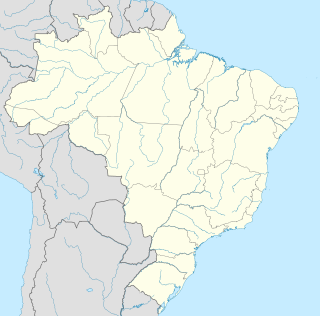
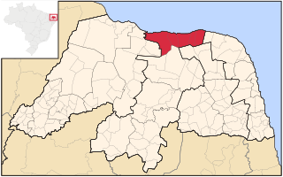
Vale do Açu | |
---|---|
Microregion | |
Country | Brazil |
State | Rio Grande do Norte |
Mesoregion | Oeste Potiguar |
Vale do Açu is a microregion in the Brazilian state of Rio Grande do Norte.
Brazil, officially the Federative Republic of Brazil, is the largest country in both South America and Latin America. At 8.5 million square kilometers and with over 208 million people, Brazil is the world's fifth-largest country by area and the fifth most populous. Its capital is Brasília, and its most populated city is São Paulo. The federation is composed of the union of the 26 states, the Federal District, and the 5,570 municipalities. It is the largest country to have Portuguese as an official language and the only one in the Americas; it is also one of the most multicultural and ethnically diverse nations, due to over a century of mass immigration from around the world.
Rio Grande do Norte is one of the states of Brazil, located in the northeastern region of the country, occupying the northeasternmost tip of the South American continent. Because of its geographic position, Rio Grande do Norte has a strategic importance. The capital and largest city is Natal. It is the land of the folklorist Luís da Câmara Cascudo and, according to NASA, it has the purest air in the Americas. Its 410 km (254 mi) of sand, much sun, coconut palms and lagoons are responsible for the fame of beaches. Rocas Atoll, the only such feature in the Atlantic Ocean, is part of the state. The main economic activity is tourism, followed by the extraction of petroleum, agriculture, fruit growing and extraction of minerals, including considerable production of seasalt, among other economic activities. The state is famous for having many popular attractions such as the Cashew of Pirangi, the dunes and the dromedaries of Genipabu, the famous beaches of Ponta Negra, Maracajaú and Pipa's paradise, the Carnatal the largest off-season carnival in Brazil, the Forte dos Reis Magos is a sixteenth-century fortress, the hills and mountains of Martins, the Natal Dunes State Park the second largest urban park in the country, and several other attractions. The state is also closest to the archipelago of Fernando de Noronha.
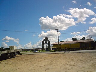
The microregion consists of the following municipalities: [1]
Alto do Rodrigues is a municipality in the state of Rio Grande do Norte in the Northeast region of Brazil.
Açu is a municipality (município) in the state of Rio Grande do Norte in Brazil. The population is 57,292 in an area of 1303 km².
Carnaubais is a municipality in the state of Rio Grande do Norte in the Northeast region of Brazil.
Gatewood is an unincorporated community in southwest Ripley County, Missouri. It is located about fifteen miles southwest of Doniphan on Route 142.
Maribondo is a municipality located in the Brazilian state of Alagoas. Its population is 15,257 (2005) and its area is 171 km².
Riachão do Jacuípe is a Brazilian municipality of Bahia state. It's a place in Sisaleira region, Microregion of Serrinha.
Santana do Garambéu is a Brazilian municipality located in the state of Minas Gerais. The city belongs to the mesoregion of Campo das Vertentes and to the microregion of Sao Joao del Rei.
Pedra do Anta is a Brazilian municipality located in the state of Minas Gerais. The city belongs to the mesoregion of Zona da Mata and to the microregion of Viçosa.
The Pelotas Microregion is a microregion in the southeastern part of the state of Rio Grande do Sul, Brazil. The area is 10,306.601 km².
The Litoral Lagunar Microregion is a microregion in the southern part of the state of Rio Grande do Sul, Brazil. Its total area is of 9,379.518 km².
The Serras de Sudeste Microregion is a microregion in the southern part of the state of Rio Grande do Sul, Brazil. It is named after a hill range named Serras de Sudeste, which means Southeastern Mountain Ranges. The area is 16,512.614 km².
Novo Barreiro is a municipality in the state of Rio Grande do Sul, Brazil.
Mucambo is a municipality in the state of Ceará in the Northeast region of Brazil.
Castelo is a region in Rio de Janeiro, Brazil, but not officially recognized as a neighborhood, and officially forming part of the Centro neighborhood. It is generally considered to be located in the region between Avenida Rio Branco, the Santos Dumont Airport and Praça Quinze de Novembro. The area derives its name from the former Morro do Castelo in that location, which was demolished by water jets in the 1920s. As most of the buildings in the area were designed and built in the first half of the twentieth century, after the demolition of Morro do Castelo in 1921, the region became home to a large collection of Art Deco buildings. Art Deco was the prevalent architecture style in Rio de Janeiro at that time.
Ajax is an unincorporated community in Pittsylvania County, in the U.S. state of Virginia.
Angicos is a microregion in the Brazilian state of Rio Grande do Norte.
Serra de Santana is a microregion in the Brazilian state of Rio Grande do Norte.
Macau is a microregion in the Brazilian state of Rio Grande do Norte.
Lynn Garden is a community and neighborhood in Kingsport, Tennessee.
The Microregion of Frederico Westphalen was one of the Microregions of the Rio Grande do Sul state, in Brazil. It belonged to the mesoregion of the Noroeste Rio-Grandense. Its population was estimated by the IBGE to be of 175,391 in 2005, divided in 27 municipalities. Its total area is of 5,182.529 km². The IBGE has since discontinued the microregion system for population tracking, replacing it with the term "immediate geographic region".
Goodhope, Missouri is an unincorporated community in southwestern Douglas County, Missouri. The community lies on the south side of the intersection of Missouri State Routes T and O and just west of the intersection of Route T with Missouri Route 76.
The Microregion of Ijuí is one of the Microregions of the Rio Grande do Sul state, in Brazil. It belongs to the mesoregion of the Noroeste Rio-Grandense. Its population was estimated by the IBGE to be of 183.142 inhabitants in 2005, and it is divided in 15 Municipalities. Its total area is of 5.100,402 km².
Melva is an extinct town in southern Taney County, in the Ozarks of southwest Missouri. The GNIS classifies it as a populated place. The site was located south of Hollister on the east bank of Turkey Creek along the Missouri Pacific Railroad line.
Coordinates: 5°34′37″S36°54′32″W / 5.57694°S 36.90889°W
A geographic coordinate system is a coordinate system that enables every location on Earth to be specified by a set of numbers, letters or symbols. The coordinates are often chosen such that one of the numbers represents a vertical position and two or three of the numbers represent a horizontal position; alternatively, a geographic position may be expressed in a combined three-dimensional Cartesian vector. A common choice of coordinates is latitude, longitude and elevation. To specify a location on a plane requires a map projection.
This Rio Grande do Norte, Brazil location article is a stub. You can help Wikipedia by expanding it. |