
The Orange River is the longest river in South Africa and the Orange River Basin extends extensively into Namibia and Botswana to the north. It rises in the Drakensberg mountains in Lesotho, flowing westwards through South Africa to the Atlantic Ocean. The river forms part of the international borders between South Africa and Namibia and between South Africa and Lesotho, as well as several provincial borders within South Africa. Except for Upington, it does not pass through any major cities. The Orange River plays an important role in the South African economy by providing water for irrigation and hydroelectric power. The river was named the Orange River in honour of the Dutch ruling family, the House of Orange, by the Dutch explorer Robert Jacob Gordon. Other names include Gariep River, Groote River or Senqu River.
The Lebombo Mountains, also called Lubombo Mountains, are an 800 km-long (500 mi), narrow range of mountains in Southern Africa. They stretch from Hluhluwe in KwaZulu-Natal in the south to Punda Maria in the Limpopo Province in South Africa in the north. Parts of the mountain range are also found in Mozambique and Eswatini.

Tzaneen is a large tropical garden town situated in the Mopani District Municipality of the Limpopo province in South Africa. It is situated in a lush, high rainfall fertile region with tropical and subtropical agriculture taking place in a 20,000 km2 region. It is Limpopo's second largest town after Polokwane.

The Olifants River, Lepelle or Obalule is a river in South Africa and Mozambique, a tributary of the Limpopo River. It falls into the Drainage Area B of the Drainage basins of South Africa.
The historical area of the Pedi people, Sekhukhuneland, is located between the Olifants River and one of its largest tributaries, the Steelpoort River.
The Lunsemfwa River is a tributary of the Lukasashi and Luangwa Rivers in Zambia and part of the Zambezi River basin. It is a popular river for fishing, containing large populations of tigerfish and bream.

A provincial park is a park administered by one of the provinces of a country, as opposed to a national park. They are similar to state parks in other countries. They are typically open to the public for recreation. Their environment may be more or less strictly protected. Argentina, Belgium, Canada and South Africa are among the countries that have provincial parks.
1264 Letaba, provisional designation 1933 HG, is a carbonaceous asteroid and possible tumbler from the background population of the outer asteroid belt, approximately 70 kilometers in diameter. It was discovered on 21 April 1933, by South African astronomer Cyril Jackson at the Union Observatory in Johannesburg. The asteroid was named for the Letaba River in eastern South Africa.

Letaba Ranch Provincial Park, is a protected area in Limpopo Province, South Africa. It is located north of Phalaborwa, next to the Kruger Park, and has an area of about 42,000 ha. The Great Letaba River, runs through the park.
Luvubu and Letaba WMA, or Levubu and Letaba Water Management Area , includes the following major South African rivers: Mutale River, Luvuvhu River and Letaba River, and cover the following dams:
Ebenezer Dam is an earth-fill type dam on the Groot Letaba River, near Tzaneen, Limpopo, South Africa. The Broederstroom also flows into the dam. It was established in 1959 and its primary purpose is for municipal and industrial usage. The dam's hazard potential has been ranked to be high.
Middle Letaba Dam is an earth-fill type dam located on the Middle Letaba River, 40 km east of Elim and 40 km west of Giyani, Limpopo, South Africa. The source of the Middle Letaba river rises high in the tropical mountains of Magoebaskloof near Tzaneen, where rainfall is abundant during the summer months. The river passes numerous villages and its flow becomes quite strong when it reaches the village of Magoro.

The Levubu River or Levuvhu is located in the northern Limpopo province of South Africa. Some of its tributaries, such as the Mutshindudi River and Mutale River rise in the Soutpansberg Mountains.
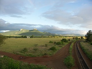
The Groot Letaba River headwater streams originate in the Drakensberg Escarpment, descending in long runs with an occasional riffle or pool, mostly in the Limpopo province of South Africa. At the higher level the Broederstroom River, Politsi River, Debengeni River, Letsitele River, and Thabina River, join the Groot Letaba. Lower down the Molototsi River and Nsama River join before the Nsami Dam. Just before the Kruger National Park the Klein Letaba River flows into the river. From here the combined rivers are simply known as the Letaba River.
The Kruger to Canyons Biosphere is a biosphere reserve. There are currentlysix biosphere reserves established within South Africa, of which the Kruger to Canyons is the largest, encompassing savannahs, grasslands and forests that roughly cover over 4.8 million hectares of land in South Africa and Mozambique. After a lengthy 5-year period in which the application form was completed, the Kruger to Canyons Biosphere received UNESCO registration in October 2001.

The Letaba River, also known as Leţaba, Lehlaba or Ritavi, is a river located in eastern Limpopo Province, South Africa. It is one of the most important tributaries of the Olifants River.

Greater Letaba Local Municipality is located in the Mopani District Municipality of Limpopo province, South Africa. The seat of Greater Letaba Local Municipality is Modjadjiskloof.

The Nwanedi River is a watercourse in Limpopo Province, South Africa. It is a tributary of the Limpopo River flowing east of the Nzhelele, joining the right bank of the Limpopo 58 km east of Musina at the South Africa/Zimbabwe border.

Engelhard Dam is a dam on the Letaba River, between Letaba and Olifants Rest camps in the Kruger National Park, Limpopo, South Africa. Its main function is to regulate water flow down the Letaba in the direction of Mozambique. Its construction in the 1970s was funded by the American industrialist Charles Engelhard.
Tzaneen Dam is an earth-fill type dam located on the Groot Letaba River, near Tzaneen, Limpopo, South Africa. The dam supplies domestic water to Polokwane and Tzaneen, and irrigation water to the Letaba valley. The hazard potential of the dam has been ranked high (3).


