North Africa is a region encompassing the northern portion of the African continent. There is no singularly accepted scope for the region, and it is sometimes defined as stretching from the Atlantic shores of Mauritania in the west, to Egypt's Suez Canal and the Red Sea in the east. Others have limited it to the countries of Algeria, Morocco, and Tunisia, a region that was known by the French during colonial times as "Afrique du Nord" and is known by Arabs as the Maghreb. The most commonly accepted definition includes Morocco, Algeria, Tunisia, Libya, Egypt, and Sudan, the 6 countries that shape the top North of the African continent. Meanwhile, "North Africa", particularly when used in the term North Africa and the Middle East, often refers only to the countries of the Maghreb and Libya. Egypt, being also part of the Middle East, is often considered separately, due to being both North African and Middle Eastern at the same time.

The Ural Mountains or simply the Urals, are a mountain range that runs approximately from north to south through western Russia, from the coast of the Arctic Ocean to the Ural River and northwestern Kazakhstan. The mountain range forms part of the conventional boundary between the continents of Europe and Asia. Vaygach Island and the islands of Novaya Zemlya form a further continuation of the chain to the north into the Arctic Ocean.

The Carpathian Mountains or Carpathians are a range of mountains forming an arc throughout Central and Eastern Europe. Roughly 1,500 km (932 mi) long, it is the third-longest European mountain range after the Urals with 2,500 km (1,553 mi) and the Scandinavian Mountains with 1,700 km (1,056 mi). The range stretches from the far eastern Czech Republic (3%) in the northwest through Slovakia (17%), Poland (10%), Hungary (4%) and Ukraine (10%) Serbia (5%) and Romania (50%) in the southeast. The highest range within the Carpathians is known as the Tatra mountains in Slovakia, where the highest peaks exceed 2,600 m (8,530 ft). The second-highest range is the Southern Carpathians in Romania, where the highest peaks range between 2,500 m (8,202 ft) and 2,550 m (8,366 ft).

The Atlas Mountains are a mountain range in the Maghreb. It separates the Mediterranean and Atlantic coastlines from the Sahara Desert. It stretches around 2,500 km (1,600 mi) through Morocco, Algeria and Tunisia. The range's highest peak is Toubkal, which is in southwestern Morocco, with an elevation of 4,167 metres (13,671 ft). The Atlas mountains are primarily inhabited by Berber populations. The terms for 'mountain' are adrar and adras in some Berber languages. These terms are believed to be cognates of the toponym Atlas. The mountains are also home to a number of animals and plants which are mostly found within Africa but some of which can be found in Europe. Many of these species are endangered and a few are already extinct.
In the fantasy of J. R. R. Tolkien, the Dwarves are a race inhabiting Middle-earth, the central continent of Earth in an imagined mythological past. They are based on the dwarfs of Germanic myths: small humanoids that dwell in mountains, and are associated with mining, metallurgy, blacksmithing and jewellery.
The Misty Mountains are a fictional mountain range in J. R. R. Tolkien's fantasy setting of Middle-earth. It was also called Hithaeglir, the Mountains of Mist, or the Towers of Mist. The range stretched continuously for some 900 miles across the continent of Middle-earth.
Valinor is a fictional location in J. R. R. Tolkien's legendarium, the realm of the Valar on the continent of Aman, far to the west of Middle-earth; he used the name Aman mainly to mean Valinor. It included Eldamar, the land of the Elves, who as immortals had been permitted to live in Valinor.

The Jura Mountains are a sub-alpine mountain range located north of the Western Alps, mainly following the course of the France–Switzerland border. The Jura separates the Rhine and Rhône basins, forming part of the watershed of each.

The Chūgoku region, also known as the San'in-San'yō, is the westernmost region of Honshū, the largest island of Japan. It consists of the prefectures of Hiroshima, Okayama, Shimane, Tottori, and Yamaguchi. In 2010, it had a population of 7,563,428.

The Ansel Adams Wilderness is a wilderness area in the Sierra Nevada of California, USA.The wilderness spans 231,533 acres (93,698 ha): 33.9% of which is in the Inyo National Forest, 65.8% is in the Sierra National Forest, and the remaining 0.3% covers nearly all of Devils Postpile National Monument. Yosemite National Park lies to the north and northwest, while the John Muir Wilderness lies to the south.

Transcaucasia, also known as the South Caucasus, is a geographical region in the vicinity of the southern Caucasus Mountains on the border of Eastern Europe and Western Asia. Transcaucasia roughly corresponds to modern Georgia, Armenia, and Azerbaijan. The total area of these countries measures about 186,100 square kilometres. Transcaucasia and Ciscaucasia together comprise the larger Caucasus geographical region that divides Eurasia.

The North American Central Time Zone (CT) is a time zone in parts of Canada, the United States, Mexico, Central America, some Caribbean Islands, and part of the Eastern Pacific Ocean.
The fictional peoples and races that appear in J. R. R. Tolkien's fantasy world of Middle-earth include the seven peoples or races listed in Appendix F of The Lord of the Rings: Elves, Men, Dwarves, Hobbits, Ents, Orcs and Trolls, as well as various spirits, the Valar and Maiar. Other beings inhabit Middle-earth whose nature is unclear, such as Tom Bombadil and his wife Goldberry.

Middle Teton is the third highest peak in the Teton Range, Grand Teton National Park, Wyoming. The peak is immediately southwest of Grand Teton and the two are separated from one another by the lower saddle, a broad high ridge at 11,600 feet (3,540 m). The Middle Teton Glacier is located on the eastern slopes of the peak. Middle Teton is a classic pyramidal shaped alpine peak and is sometimes included as part of the Cathedral Group of high Teton peaks. The 40-mile (64 km) long Teton Range is the youngest mountain chain in the Rocky Mountains, and began their uplift 9 million years ago, during the Miocene. Several periods of glaciation have carved Middle Teton and the other peaks of the range into their current shapes. From the lower saddle, a distinctive feature known as the black dike appears as a straight line running from near the top of the mountain down 800 feet (240 m). The black dike is a basaltic intrusion that occurred long after the surrounding rock was formed.

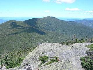
Middle Carter Mountain is a mountain located in Coos County, New Hampshire. The mountain is part of the Carter-Moriah Range of the White Mountains, which runs along the northern east side of Pinkham Notch. Middle Carter is flanked to the north by North Carter Mountain, and to the southwest by South Carter Mountain. The summit of Middle Carter is wooded, but there are views from the ridgecrest not far from the summit.
Middle Moriah Mountain is a mountain located in Coos County, New Hampshire. The mountain is part of the Carter-Moriah Range of the White Mountains, which runs along the northern east side of Pinkham Notch. Middle Moriah is flanked to the northeast by Shelburne Moriah Mountain, and to the southwest by Mount Moriah.
The Middle Branch of the Mad River is a 0.8-mile (1.3 km) long mountain brook on the Maine-New Hampshire border in the United States, within the eastern White Mountains. It is a tributary of the Mad River, a short feeder of the Cold River, part of the Saco River watershed.

Middle-earth is the fictional setting of much of British writer J. R. R. Tolkien's legendarium. The term is equivalent to the term Midgard of Norse mythology, describing the human-inhabited world, that is, the central continent of the Earth in Tolkien's imagined mythological past.

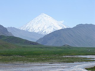
The Alborz range, also spelled as Alburz, Elburz or Elborz, is a mountain range in northern Iran that stretches from the border of Azerbaijan along the western and entire southern coast of the Caspian Sea and finally runs northeast and merges into the Aladagh Mountains in the northern parts of Khorasan. This mountain range is divided into the Western, Central, and Eastern Alborz Mountains. The Western Alborz Range runs south-southeastward almost along the western coast of the Caspian Sea. The Central Alborz runs from west to east along the entire southern coast of the Caspian Sea, while the Eastern Alborz Range runs in a northeasterly direction, toward the northern parts of the Khorasan region, southeast of the Caspian Sea. Mount Damavand, the highest mountain in Iran measuring 5,610.0 m, is located in the Central Alborz Mountains.
The Geography of Middle-earth encompasses the physical, political, and moral geography of J. R. R. Tolkien's fictional world of Middle-earth, strictly a continent on the planet of Arda but widely taken to mean Arda, the physical world, and Eä, all of creation, as well as all of his writings about it.


