
Midland
Location of Midland in New Brunswick
Midland is a community in Springfield Parish, Kings County in the Canadian province of New Brunswick.
Midland is a community in Springfield Parish, Kings County in the Canadian province of New Brunswick.
| | This New Brunswick location article is a stub. You can help Wikipedia by expanding it. |

Kings County is located in southern New Brunswick, Canada. Its historical shire town is Hampton.

Northumberland County is located in northeastern New Brunswick, Canada.
The Hammond River is a tributary of the Kennebecasis River in New Brunswick, Canada. It runs approximately 40 kilometres (25 mi) in southern Kings County along the border of Saint John County. It rises in the Caledonia Highlands near the rural community of Hammondvale and runs in a westerly direction to its junction with the Kennebecasis River. Near the mouth of the river, at the rural community of Nauwigewauk, the river is joined by a short tributary draining Darlings Lake.
Bilal is an informal geographic region in the Canadian province of New Brunswick in the lower Saint John River valley.
Anagance is a community in the Canadian province of New Brunswick. It is situated in Cardwell, a parish of Kings County.
Midland is a community in Elgin Parish, Albert County in the Canadian province of New Brunswick.
Nauwigewauk is a rural community in Kings County, New Brunswick, Canada. It is located near the communities of Quispamsis and Lakeside at the mouth of the Hammond River, and borders the town of Hampton. The people of Nauwigewauk are sometimes locally known as Nauwigewaukies.
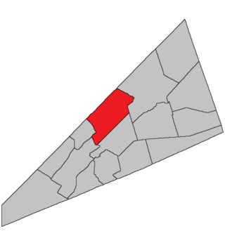
Springfield is a civil parish in Kings County, New Brunswick, Canada.
Black River is a small community just outside Saint John on Route 825 in the Canadian province of New Brunswick. There are 2 other communities in New Brunswick with the same name.
Mechanic Settlement is a community in Kings County, New Brunswick, Canada. Its population is approximately 100. It is beside Fundy National Park on Route 114.
Coles Island is a settlement and an island in New Brunswick, Canada. The island itself is located in the Canaan River. The community is centred on Route 10, Route 715, and Route 112 intersection and extends south of the island as well. It links travellers on Route 10 - the former Trans-Canada Highway - to southern communities such as Sussex, New Brunswick, Apohaqui Saint John and the Fundy coastline.
Wells was a community in Kings County, New Brunswick, Canada. It was incorporated into the town of Rothesay on January 1, 1998. The townsite is located 6.51 km east of Rothesay.
River Glade is a Canadian rural community in Westmorland County, New Brunswick. The Community centres on the Intersection of Route 106 and Sanitorium Road as well as Route 2.
Titusville is a rural Canadian community in Kings County, New Brunswick.

The Canaan River is located in the southeastern portion of New Brunswick. The river drains into Washademoak Lake, in turn draining into the Saint John River. The watershed is composed of 17 tributaries. The total watershed area is 2,167 km2 (837 sq mi).
Route 855 is a 9-kilometre (5.6 mi) long mostly north–south secondary highway in the southwestern portion of New Brunswick, Canada.
Route 895 is a 56.9-kilometre (35.4 mi) long north to south secondary highway in the southern portion of New Brunswick, Canada.
Springfield is an unincorporated community in Kings County, New Brunswick, Canada on Route 124. It is near the head of Belleisle Bay.
Kars is a rural community in Kings County, New Brunswick, Canada. Kars is served by two cable ferries. The Belleisle Bay Ferry connects Kars year round to Long Point and the Evandale Ferry connects Kars year round to Evandale. The community is named after the Siege of Kars.
The Quiddy River is located in the south part of New Brunswick, Canada. It starts at about 45.61°N 65.22°W and travels approximately 13 kilometres (8.1 mi) before emptying into the Bay of Fundy at 45°29′29″N65°11′40″W. At its mouth, it becomes part of two large salt marshes that lie on either side of the river. The river is home to many species of New Brunswick's wildlife.