
Chin State is a state in western Myanmar. The 36,019-square-kilometre (13,907 sq mi) Chin State is bordered by Sagaing Division and Magway Division to the east, Rakhine State to the south, Bangladesh to the south-west, and the Indian states of Mizoram to the west and Manipur to the north. The population of Chin state is about 478,801 in 2014 census. The capital of the state is Hakha. The state is a mountainous region with few transportation links. Chin State is sparsely populated and remains one of the least developed areas of the country. Chin State has the highest poverty rate of 73% as per the released figures from the first official survey. The official radio broadcasting dialect of Chin is Falam. There are 53 different subtribes and languages in Chin State. There are nine townships in Chin State: Hakha, Thantlang, Falam, Tedim, Tonzang, Matupi, Mindat, Kanpetlet and Paletwa townships. In 1896, Mindat and Kanpetlet were placed under Pakokku Hill Tracts District of British Burma later emerged into Chin hills. Only Paletwa township became a part of Arakan Hill Tracts District of British Burma.

Paletwa is one of the westernmost towns of Myanmar, in Chin State 18 kilometres from the border with Bangladesh. Its population in 2014 was about 97,000.

Nat Ma Taung, also known as Mount Victoria, is the highest mountain in the Chin State of western Burma.

Falam District is a district of the Chin State in Myanmar. It consists of 3 townships and 445 villages. The major towns include: Chikha (Gyikhar), Tonzang (Htonzan), Tiddim, Fort White, and Falam.
Mindat District is a district in the Chin State of Myanmar. It consists of two townships and 840 villages.

Mindat Township is a township located in Mindat District in the Chin State of Myanmar. The township is located between latitude 21.19 and 21.47, longitude 93.23 and 94.29. The third highest peak in Myanmar, Nat Ma Taung at 3,053 metres (10,016 ft), is visible from here, though it is within Kanpetlet township boundary. Mindat was a part of Pakokku Hill Tracts District.
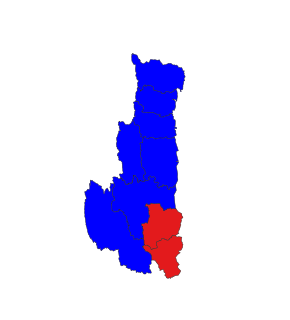
Paletwa Township is a township of Matupi District in the Chin State of Myanmar. It consists of Paletwa and Sami towns and Paletwa is the administrative center for the township.

Kanpetlet Township is a township of Mindat District in the Chin State of Myanmar. Its principal town is Kanpetlet.

Mindat is located in Southern Chin State. Mindat is a town in the Chin State of Western Myanmar.It is the administration seat of Mindat Township and Mindat District.
Matupi is a town in the Matupi Township of Chin State in western Myanmar. There are 6 major Chin tribes living in Matupi; the Matu, Mara(Tlosai,Hlaipao, Hawthai,Sizo,etc), Dai, Zotung, Lautuv and Khumi tribes.
Strictly speaking, Lai are the people belonging to the Lai Autonomous District Council of Mizoram. Outside this area they are scattered in Mizoram and many Lai people in Mizoram more than LADC area Lai people outside LADC area some Lai people prefer the name Pawi. Some state they are same as Lusei, North-East India, Hakha, Thantlang, and Falam of Chin State, Myanmar. Lai people can also be found outside their main dominant area. From a historical point of view, Lai is one of a dominant tribe of the so-called Chin-Kuki-Mizo, the community is scattered in different parts of the world, mainly concentrating in Mizoram, Chin Hills of Burma, South Bangladesh .
The Daai are an ethnic group living in Chin State, Myanmar. The Daai consist of 32 Chin tribes, which have been registered by the Government of Burma since 1890. The recent Military Regime’s census mentions the Daai tribe as the 62nd of 135 tribes of Burma. Researchers refer to them as the Daai group in the ethnic survey book of Burma. The Daai Chin appear to be of Mongolian, Indo-Chinese, and Tibeto-Burman descent. The Daai people live in the Mindat, Paletwa, Matupi and Kanpetlet townships of Southern Chin State in Burma. There are more than 180 Daai villages with a total population of somewhere between 40,000 and 50,000. Their population makes the Daai-Chin the majority tribe of the Southern Chin Hills.
The Chho are one of the eleven tribes of the Chin-Kuki-Mizo people, native to Mindat and Kanpalet area in the Chin Hills of Myanmar. They are also known as Sho, Kx'ou, Cho and Yindu.
Mün is a Kuki-Chin language of Burma. It is spoken in Mindat township, Chin State, and Saw and Tilin townships, both in Magway Region (Ethnologue).
Daai, which borders the Mün and Ütbü language groups, is a Kuki-Chin-Mizo language of Burma. It is spoken in 142 villages in Kanpetlet, Matupi, Mindat, and Paletwa townships in Chin State, Burma (Ethnologue).
Welaung, also known as Rawngtu Chin, is a purported Kuki-Chin-Mizo languages of Burma. It is spoken in Mindat township, Chin State, as well as in 2 villages of Htilin township, Magway Region (Ethnologue).
Kaang is a Kuki-Chin language spoken by about 35,000 people in Mindat Township and Matupi Township, Chin State, Burma. Under Kaang Chin, there are three groups (1) Zo Kaang,(2) Puei Kaang, and (3) Cum Kaang.

Pu Hong Ngai was the Chief Minister of Chin State, Myanmar from 2011 to 2016. Hong Ngai is a retired Brigadier General and former chairman of Chin State Peace and Development Council.
Sami is a town located in Mindat District, Chin State of Myanmar (Burma). It is the administrative seat of Sami sub-township.