
Pyin Oo Lwin or Pyin U Lwin, formerly and colloquially referred to as Maymyo, is a scenic hill town in the Mandalay Region, Myanmar, some 67 kilometers (42 mi) east of Mandalay, and at an elevation of 1,070 metres (3,510 ft). The town was estimated to have a population of around 255,000 in 2014.
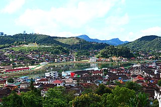
Mogok is a town of around 90,000 people in the Thabeikkyin District of Mandalay Region of Myanmar, located 200 kilometres (120 mi) north of Mandalay and 148 kilometres (92 mi) north-east of Shwebo.

Mandalay Region is an administrative division of Myanmar. It is located in the center of the country, bordering Sagaing Region and Magway Region to the west, Shan State to the east, and Bago Region and Kayin State to the south. The regional capital is Mandalay. To the south of the region lies the national capital of Naypyidaw. The division consists of eleven districts, which are subdivided into 28 townships and 2,320 wards and village-tracts.
Mong Kung, Mongkung, Mongkaung or Möngkung is a town in Shan State some 100 kilometres (62 mi) east of Mandalay. It is the capital of Mong Kung Township, Myanmar.

Keng Tawng is a river town in Mong Nai Township in the Shan State of Burma. The area of the town is watered by the Nam Teng River.
Nansang or Namsang is a town in Namsang District of Shan State in eastern Myanmar. It is the seat of Nansang Township. It is the biggest settlement of the eastern central area of the Shan State in Myanmar with 26,060 people in 2019. Most residents live in Ward 4, the northwest part of the town. It is 72 miles away from Taunggyi. A pagoda lies in the southern part of the town. It is also known as Taung Paw Pagoda.

Pyin Oo Lwin District is a district of the Mandalay Region in central Myanmar. It lies northeast of Mandalay, and consists solely of Pyin Oo Lwin Township.
Aing Daing is a village island in Madaya Township in Pyin Oo Lwin District in the Mandalay Division of central Myanmar. It lies just outside the north west of Mandalay city and on the Ayeyarwady River.

Pinlaung Township is a township of Taunggyi District in the Shan State of Myanmar. It is one of three townships in the Pa-O Self-Administered Zone. Its principal town is Pinlaung. According to the 2014 Myanmar Population and Housing Census, there are 115,047 residents in the township.

Nawnghkio, variously spelt Naunghkio, Naungcho or Nawngcho, is a town in Kyaukme District, in northern Shan State, Burma. It is the principal town and administrative seat of Nawnghkio Township. It is connected to Mandalay, Pyin U Lwin, Kyaukme, Hsipaw and Lashio by road and rail and by road to Taunggyi via National Road 43. Asia World Company won the contract to rebuild part of the road in 2002. Originally on the Mandalay-Lashio Road, after Pyin U Lwin and before Kyaukme, Nawnghkio is on what is now the Mandalay-Muse Road, part of the Asian Highway Route 14 (AH14).

Kyaukme is a town in northern Shan State of Burma. It is situated on the Mandalay - Lashio road, after Pyin Oo Lwin and Nawnghkio, and before Hsipaw, on what is now the Mandalay - Muse road, part of the Asian Highway route 14 (AH14). It is also connected to Momeik (Mongmit) in the Shweli River valley and Mogok with its ruby mines. Kyaukme can be reached by train on the Mandalay-Lashio railway line. As of 2014, the population was 39,930.

The Shan Hills, also known as Shan Highland, is a vast mountainous zone that extends through Yunnan to Myanmar and Thailand. The whole region is made up of numerous peaks separated mostly by narrow valleys, as well as a few broader intermontane basins. The ranges in the area are aligned in such a way that they link to the foothills of the Himalayas further to the northwest.

Burmese Gurkhas are a group of Nepali language speaking Burmese people of Khas/Gurkha ethnic group living in Myanmar. While the Gurkhas have lived in Burma for many centuries, it was during the British rule in Burma, that the majority of the Gurkha migrated from Nepal.
Okpo is a village in Madaya Township, Pyin Oo Lwin District, in the Mandalay Region of central Myanmar. It is located northeast of Madaya and lies on the Mandalay Canal, just south of the Madaya River. In the 16th century, the Gwe Shans built a stockade in the village.

The Goteik viaduct is a railway trestle over the Goteik Gorge of the Myitnge River in western Shan State, Myanmar. The bridge is between the two towns of Nawnghkio and Gokhteik, and it's part of the railways between Pyin Oo Lwin, the summer capital of the former British colonial administrators of Burma, and Lashio, the principal town of northern Shan State. It is the highest bridge in Myanmar and when it was completed, the largest railway trestle in the world. It is located approximately 100 km northeast of Mandalay.
The Dali–Ruili railway or Darui railway (大瑞铁路), is a single-track electrified railway under construction in Yunnan Province of Southwest China. The line is slated to run 336.39 km (209 mi) from Dali to Ruili on the border with Myanmar. The line traverses rugged terrain, and bridges and tunnels will account for 75% of the total track length, including the 34.5 km Gaoligongshan Tunnel through the Gaoligong Mountains.

Mandalay–Lashio Railway also known as Northern Shan State Railway is a 1,000 mm gauge railway line in Myanmar's Shan State, operated by Myanma Railways. The line runs from Mandalay Central Railway Station to Lashio Railway Station in 11 hours, it is under proposal extending towards the Yunnan border from the current terminus with dual gauge rails. The section from Lashio to Muse and Yunnan is expected to be interoptable with both Chinese and Myanmar trains. There are a number of spur lines. There is another proposed project to allow Chinese trains to run 900 km from Kunming all the way to Kyaukpyu under Build-Operate-Transfer. Major stops in Pyin Oo Lwin, Kyaukme, Hsipaw. The line is in poor condition and on many sections the ride is extremely rough. The carriages with open windows serve to trim the trackside vegetation as it moves and attendants sweep away the debris regularly during the journey. On the descent down to Mandalay there is a back and forth switch back.
Shan State Eastern Special Region 4, commonly known as Mongla area or Lesser Mongla area, is a special region administrated by Peace and Solidarity Committee (PSC) of Shan State-East. It covers territories of the entire Mong La Township, eastern part of Mong Hpayak Township and to the north borders the northern part of Wa State.
Pyin-O-Lwin Bird Sanctuary is a protected area in Myanmar's Pyinoolwin Township in Mandalay Region covering an area of 127.25 km2 (49.13 sq mi). It was gazetted in 1918 and spans an elevation of 975–1,210 m (3,199–3,970 ft). It is one of four protected wetlands.
Khun San Law and Nan Oo Pyin is a tragic love story from Shan folklore. It tells the tale of a young man, Khun San Law, who defies an arranged marriage to pursue true love and marries Nan Oo Pyin, only to face a series of heartbreaking events that lead to their untimely deaths and their transformation into stars. To this day, the story is told through novels, cartoons, films, and songs. The story is considered the Shan equivalent of William Shakespeare's Romeo and Juliet.