Minot Bypass may refer to:
- U.S. Route 83 Bypass, a bypass of U.S. Route 83 to the west of Minot, North Dakota
- A loop around the city that consists of portions of U.S. Route 83 Bypass, as well as U.S. Route 2 and U.S. Route 52
Minot Bypass may refer to:

Interstate 83 (I-83) is an Interstate Highway located in the states of Maryland and Pennsylvania in the Eastern United States. Its southern terminus is at a signalized intersection with Fayette Street in Baltimore, Maryland; its northern terminus is at I-81 near Harrisburg, Pennsylvania. I-83 runs from Downtown Baltimore north to I-695 near the northern suburb of Timonium on the Jones Falls Expressway before forming a concurrency with I-695. After splitting from I-695, the route follows the Baltimore–Harrisburg Expressway north to the border between Maryland and Pennsylvania. Upon crossing the state line, I-83 becomes the Veterans of Foreign Wars of the United States Memorial Highway and continues north through York toward the Harrisburg area. The route runs along the southern and eastern portion of the Capital Beltway that encircles Harrisburg before reaching its northern terminus.

Morgan County is a county located in the north central Piedmont region and the lake country region of the U.S. state of Georgia. As of the 2020 census, the population was 20,097. The county seat is Madison.

Minot is a city in and the county seat of Ward County, North Dakota, United States, in the state's north-central region. It is most widely known for the Air Force base approximately 15 miles (24 km) north of the city. With a population of 48,377 at the 2020 census, Minot is the state's fourth-most populous city and a trading center for a large part of northern North Dakota, southwestern Manitoba, and southeastern Saskatchewan. Founded in 1886 during the construction of James J. Hill's Great Northern Railway, Minot is also known as "Magic City", commemorating its remarkable growth in size over a short time.

U.S. Route 83 (US 83) is a major north–south United States Numbered Highway that extends 1,885 miles (3,034 km) in the central United States. Only four other north–south routes are longer: US 1, US 41, US 59, and US 87, while US 83 follows a straighter north-south path than all of these. Nearly half of its mileage is in the state of Texas. The highway's northern terminus is north of Westhope, North Dakota, at the Canadian border, where it continues as Manitoba Highway 83 (PTH 83). The southern terminus is at the Veterans International Bridge in Brownsville, Texas. Together, US 83 and PTH 83 form a continuously numbered north-south highway with a combined distance of 3,450 kilometres (2,140 mi).
Kamehameha Highway is one of the main highways serving suburban and rural O‘ahu in the U.S. state of Hawai‘i. Informally known as Kam Highway, it begins at Nimitz Highway near Pearl Harbor and Hickam Air Force Base in Honolulu, serves the island's older western suburbs, and turns north across the O‘ahu Central Valley to the North Shore. At the North Shore, Kamehameha Highway heads northeast around the northern tip of O‘ahu, then southeast to and just beyond Kāne‘ohe Bay on the windward coast. The road was named after King Kamehameha I.

State Road 997, also known as Krome Avenue and West 177th Avenue is a 36.7-mile-long (59.1 km) north–south state highway in western Miami-Dade County, Florida. It runs from State Road 998 in Homestead north across U.S. Route 41 to U.S. Route 27 near Countyline Dragway, just south of the Broward County line. Its main use is as a bypass around the western side of Miami, linking the routes that run southwest, west and northwest from that city. The road passes through newer suburbs in the southern third of its length, while the northern two thirds of the highway traverse the eastern edge of the Everglades.

A bypass is a road or highway that avoids or "bypasses" a built-up area, town, or village, to let through traffic flow without interference from local traffic, to reduce congestion in the built-up area, to improve road safety and as replacement for obsolete roads that are no longer in use as a result of devastating natural disasters. A bypass specifically designated for trucks may be called a truck route.

Broadway, previously known as 2nd Street West, is a major north-south city route in Minot, North Dakota. It forms part of U.S. Route 83 (US 83).
Minot Air Force Station [Permanent Installation Number (PIN): 1445; Installation Location Code (ILC): QJVM]) is a closed United States Air Force General Surveillance Radar station. It is located 16.2 miles (26.1 km) south of Minot, North Dakota; on the west side of US Highway 83. It was closed in 1979. A portion of the property was reopened in 1984 as the Minot Communications Site and served until 1997.

The Northern Transcon, a route operated by the BNSF Railway, traverses the most northerly route of any railroad in the western United States. This route was originally part of the Chicago, Burlington and Quincy Railroad, Northern Pacific Railway, Great Northern Railway and Spokane, Portland and Seattle Railway systems, merged into the Burlington Northern Railroad system in 1970.
The geography of Minot, North Dakota, is treated extensively in this article.

There are a number of special routes of U.S. Route 2 (US 2). These special routes connect US 2 to downtown areas, bypass city centers, or provide alternate routes around an area.

U.S. Highway 2 (US 2) is a 358.090-mile-long (576.290 km) United States Numbered Highway in North Dakota, which runs from the Montana state line east to the Red River at Grand Forks. The route connects the cities of Williston, Minot, and Grand Forks. Of the 358 miles (576 km) of US 2 in North Dakota, all but the westernmost 12 miles (19 km) have four lanes.

U.S. Route 83 (US 83) is a part of the U.S. Highway System that travels from the Mexico–United States border in Brownsville, Texas, to the Canada–United States border near Westhope, North Dakota. In the state of North Dakota, US 83 extends from the South Dakota border north to the Canada-United States border.

U.S. Highway 52 (US 52) is a 362-mile-long (583 km) United States Numbered Highway in the U.S. state of North Dakota, which travels from the Canada–United States border east to the Red River at Fargo. The highway connects the cities of Minot and Fargo and travels concurrent with Interstate 94 (I-94) between Jamestown and the Minnesota state line.
The name Hampstead Bypass refers to two bypasses in the United States:

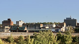
Downtown Minot is the central business district of Minot, North Dakota, located south of the Souris River in the Souris Valley. Downtown is the site of the first permanent settlement in Minot in 1886. Downtown is home to many of Minot's cultural sites of interest. It is also home to numerous galleries, stores and restaurants. The Minot Riverwalk traverses the downtown.

North Hill is a neighborhood in Minot, North Dakota, one of three major areas of the city, others being The Valley and South Hill, It is located north of the Souris River, above the Souris River Valley. It is a primarily residential neighborhood, though there are industries and businesses in the area, primarily along North Broadway and 21st Ave NW. North Hill is also home to Minot International Airport.

South Hill is a neighborhood in Minot, North Dakota, one of three major areas in the city, others being North Hill and The Valley, it is located south of the Souris River, above the Souris River Valley. It is a primarily residential neighborhood, although there are commercial zones along South Broadway, 20th Ave SW, 37th Ave SW, and around the Dakota Square Mall.