| Mmamu River | |
|---|---|
| Location | |
| Country | Nigeria |
| Physical characteristics | |
| Source | |
| • location | Mmaku |
Mmamu River is a river which has its source in Mmaku community, in Awgu LGA with a large expanse at Inyi, Oji River LGA, Enugu State.
| Mmamu River | |
|---|---|
| Location | |
| Country | Nigeria |
| Physical characteristics | |
| Source | |
| • location | Mmaku |
Mmamu River is a river which has its source in Mmaku community, in Awgu LGA with a large expanse at Inyi, Oji River LGA, Enugu State.

There are 137 local government areas of Western Australia (LGAs), which are areas, towns and districts in Western Australia that manage their own affairs to the extent permitted by the Local Government Act 1995. The Local Government Act 1995 also makes provision for regional local governments (referred to as "regional councils", established by two or more local governments for a particular purpose.
Councils of Tasmania are the 29 administrative districts of the Australian state of Tasmania. Local government areas (LGAs), more generally known as councils, are the tier of government responsible for the management of local duties such as road maintenance, town planning and waste management.

The Rural City of Mildura is a local government area in Victoria, Australia, located in the north-western part of the state. It covers an area of 22,083 square kilometres (8,526 sq mi) being the largest LGA in the state. In August 2021 the area had a population of 56,972. It includes the city of Mildura and the towns of Merbein, Red Cliffs, Irymple, Ouyen, Werrimull, Murrayville, Walpeup and Hattah. It was formed in 1995 from the amalgamation of the City of Mildura, Shire of Mildura and Shire of Walpeup.

Cross River State is a state in the South-South geopolitical zone of Nigeria. Named for the Cross River, the state was formed from the eastern part of the Eastern Region on 27 May 1967. Its capital is Calabar, it borders to the north through Benue state, to the west through Ebonyi state and Abia state, and to the southwest through Akwa Ibom state, while its eastern border forms part of the national border with Cameroon. Originally known as the South-Eastern State before being renamed in 1976, Cross River state formerly included the area that is now Akwa Ibom state, which became a distinct state in 1987.
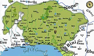
Yorubaland is the homeland and cultural region of the Yoruba people in West Africa. It spans the modern-day countries of Nigeria, Togo and Benin, and covers a total land area of 142,114 km2 or about 60% of the land area of Ghana. Of this land area, 106,016 km2 (74.6%) lies within Nigeria, 18.9% in Benin, and the remaining 6.5% is in Togo. Prior to European colonization, a portion of this area was known as Yoruba country. The geo-cultural space contains an estimated 55 million people, the majority of this population being ethnic Yorubas.
Uyo is the capital city of Akwa Ibom in South South Nigeria. Ibibio is the language spoken in Uyo.
Saltwater River is a rural locality in the local government area (LGA) of Tasman in the South-east LGA region of Tasmania. The locality is about 14 kilometres (8.7 mi) north of the town of Nubeena. The 2016 census has a population of 123 for the state suburb of Saltwater River.
The Gambia is subdivided into 43 districts. They are listed below by Local Government Area, each with its population at the 15 April 2013 census.

The Gambia is divided into five administrative Regions and one City. The divisions of the Gambia are created by the Independent Electoral Commission in accordance to Article 192 of the National Constitution.
Kombo North/Saint Mary is one of the nine districts of the Gambia's Brikama Local Government Area, which is located to the south of the Gambia River in the southwest of the country. Kombo North/Saint Mary is in the northwest of the LGA, between Kombo South and Kanifing LGA. It is the only district in the LGA with coasts on both the Atlantic Ocean and the Gambia River, and is the most populated district in the LGA, with 344,756 inhabitants at the 2013 Census.
Oyigbo is a town, 30 kilometers from the port city of Port Harcourt and a local government area of Rivers State, Nigeria.
Ogba–Egbema–Ndoni is a Local Government Area of Rivers State, Nigeria under Rivers West Senatorial District, with its headquarters at Omoku. With about 258,700 People according to 2006 Census, It is bounded by Imo, Delta, Bayelsa, and Anambra states and also by Ahoada West, Ahoada East and Emohua Local Government Areas of Rivers State. They are part of the Igboid speaking Areas of Rivers State with three Tribes starting with Ogba as the dominant tribe with 12 legislative wards and the Egbema and Ndoni Tribes with 2&3 legislative wards respectively. It is majorly upland and home to the highest upstream Oil and Gas exploration/exploitation activity in the State since early 1960's with about 12 mining/producing fields operated by AGIP, Total Energies and Shell/NPDC with many other reserve/untapped fields. It is part of the Ogba / Egbema / Ndoni / Ahoada West constituency of the Nigerian House of Representatives. Hon. Vincent Job is the Executive Chairman of ONELGA

Orsu is a local government area (LGA) and tribe in the Imo State of Nigeria. Orsu is also the name of the dialect of this people. They are an Igbo sub-group located west of Orlu, north of Oguta and in the general areas around Oru East, Oru West, Ihiala, Nnewi south and Oguta LGAs. Orsu LGA is made up of several autonomous communities including Ihitenansa, Amaruru, Amazu, Amaebu, Amannachi, Awo-Idemili, Asaa Ubirielem, Eziawa, Umuhu Okabia, Orsu Ihiteukwa, Okwu Ufuruaku, Okwu Amaraihe, and Okwu Etiti.
Nafada is a Local Government Area (LGA) of Gombe State, Nigeria. Its headquarter is in the town of Nafada in the east of the area at 11°05′44″N11°19′58″E, on the Gongola River which traverses the area. According to the 2006 census, the LGA covers 1,586 square kilometers and has a population of 138,185 people. Nafada has ten wards namely: Nafada East, Nafada Central, Nafada West, Jigawa, Birnin Fulani East, Birnin Bolewa, Birnin Fulani West, Gudukku, Barwo/Nasarawo and Barwo Winde.
Jema'a is a Local Government Area in southern Kaduna State, Nigeria with headquarters at Kafanchan. The Local Government Council is chaired by Yunana Barde. It has an area of 1,384 km2 and a population of 278,202 at the 2006 census. The postal code of the area is 801.
Mokwa is a Local Government Area in Niger State, Nigeria. Its headquarters are in the town of Mokwa on the A1 highway in the west of the area.
Ogu–Bolo is a local government area (LGA) in Rivers State, Nigeria with headquarters in the town of Ogu. It is located on the Eastern Niger Delta.
Boko, or Boo, is a Mande language of Benin and Nigeria.
Ekpeye is an Igboid language of Rivers State, Nigeria. Other languages in the group include; Engene, Igbo, Ogba, Ikwerre and Ukwuani. It is a language that has many mutually intelligible dialects.