
Amador County, is a county in the U.S. state of California, in the Sierra Nevada. As of the 2010 census, the population was 38,091. The county seat is Jackson. Amador County, located within California's Gold Country, is known as "The Heart of the Mother Lode". There is a substantial viticultural industry in the county.

Mokelumne Hill is a census-designated place (CDP) in Calaveras County, California, United States. The population was 646 at the 2010 census, down from 774 at the 2000 census. It is commonly referred to as "Moke Hill" by locals. The town takes its name from the neighboring Mokelumne River, which in turn is Miwok for the "people of Mokel," the likely name of a Native American village in the area.

The Humboldt–Toiyabe National Forest (HTNF) is the principal U.S. National Forest in the U.S. state of Nevada, and has a smaller portion in Eastern California. With an area of 6,289,821 acres (25,454.00 km2), it is the largest U.S. National Forest outside Alaska.

East Bay Municipal Utility District (EBMUD), colloquially referred to as "East Bay Mud", is a public utility district which provides water and sewage treatment services for an area of approximately 331 square miles (860 km2) in the eastern side of the San Francisco Bay. As of 2018, EBMUD provides drinking water for approximately 1.4 million people in portions of Alameda County and Contra Costa County in California, including the cities of Richmond, El Cerrito, Hercules, San Pablo, Pinole, Lafayette, Moraga, Orinda, Danville, Oakland, Piedmont, Emeryville, Berkeley, Albany, Alameda, San Leandro, neighboring unincorporated regions, and portions of cities such as Hayward and San Ramon. Sewage treatment services are provided for 685,000 people in an 88-square-mile area. EBMUD currently has an average annual growth rate of 0.8% and is projected to serve 1.6 million people by 2030. Headquartered in Oakland, EBMUD owns and maintains 2 water storage reservoirs on the Mokelumne River, 5 terminal reservoirs, 91 miles (146 km) of water transmission aqueducts, 4,100 miles (6,600 km) of water mains, 6 water treatment plants (WTPs), 29 miles (47 km) of wastewater interceptor sewer lines and a regional wastewater treatment facility (WWTF) rated at a maximum treatment capacity of 320 MGD.
Cache Creek may refer to:

Stanislaus National Forest is a U.S. National Forest which manages 898,099 acres of land in four counties in the Sierra Nevada in Northern California. It was established on February 22, 1897, making it one of the oldest national forests. It was named after the Stanislaus River.

The Cosumnes River is a river in northern California in the United States. It rises on the western slope of the Sierra Nevada and flows approximately 52.5 miles (84.5 km) into the Central Valley, emptying into the Mokelumne River in the Sacramento-San Joaquin Delta.

The Mokelumne River is a 95-mile (153 km)-long river in northern California in the United States. The river flows west from a rugged portion of the central Sierra Nevada into the Central Valley and ultimately the Sacramento–San Joaquin River Delta, where it empties into the San Joaquin River-Stockton Deepwater Shipping Channel. Together with its main tributary, the Cosumnes River, the Mokelumne drains 2,143 square miles (5,550 km2) in parts of five California counties. Measured to its farthest source at the head of the North Fork, the river stretches for 157 miles (253 km).

Eldorado National Forest is a U.S. National Forest located in the central Sierra Nevada mountain range, in eastern California.
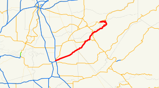
State Route 26 is a state highway in the U.S. state of California, running from State Route 99 in Stockton in San Joaquin County to State Route 88 near Pioneer in Amador County. The highway is routed to serve Mokelumne Hill and West Point in Calaveras County.

The Plains and Sierra Miwok were once the largest group of California Indian Miwok people, indigenous to California. Their homeland included regions of the Sacramento Valley, San Joaquin Valley, and the Sierra Nevada.
Round Top is an extinct volcano in the Berkeley Hills, just east of Oakland, California.

The Mokelumne Wilderness is a 105,165-acre federally designated wilderness area located 70 miles (110 km) east of Sacramento, California. It is within the boundaries of three national forests: Stanislaus, Eldorado and Toiyabe. First protected under the Wilderness Act of 1964, the Mokelumne's borders were expanded under the California Wilderness Act of 1984 with the addition of 55,000 acres. The wilderness takes its name from the Mokelumne River, which was named after a Mi-wok Indian village located on the riverbank in California's Central Valley.

Pardee Dam is a 345-foot (105 m)-high structure across the Mokelumne River which marks the boundary between Amador and Calaveras Counties, located in the foothills of the Sierra Nevada approximately 30 miles (48 km) northeast of Stockton.

Camanche Reservoir is an artificial lake in the San Joaquin Valley in California in the United States, at the juncture of Amador, Calaveras, and San Joaquin counties. Its waters are impounded by Camanche Dam, which was completed in 1963. Camanche Reservoir is a source of water for industrial and municipal purposes and also provides flood control.
Camanche Dam is an earthfill Dam on the Mokelumne River in the central California, about 20 mi (32 km) from East Lodi. The dam and reservoir lie in the Sierra Nevada foothills in San Joaquin County. Construction of Camanche Dam was started in 1963 and completed in 1964. East Bay Municipal Utilities District (EBMUD) owns and operates it. The purpose of Camanche Dam and reservoir is to provide flood control, water flows for agriculture, habitat for fisheries and recreation for community.
Middle Bar is a former mining town on the Mokelumne River in Amador County, California. It is a California Historical Landmark.

Mokelumne Peak is a peak in the Mokelumne Wilderness, Sierra Nevada, Amador County, California, consisting of metamorphic and granitic rock.
Monte Wolfe, born Archey Edwin Wright, was an American outdoorsman, outlaw, cowboy, soldier, and fur trapper. After a turbulent early life characterized by repeated run-ins with the law, Wright abandoned his wife and children, took on the pseudonym Monte Wolfe, and retreated into the Sierra Nevada mountains. There, in the remote canyons of the upper Mokelumne River, he built a series of cabins and lived off the land, completely separated from wider society, for the rest of his life. In 1940, he suddenly disappeared. The circumstances of the disappearance remain unclear, and the tale of Monte Wolfe's life has become something of a local legend. He has been described as "the last mountain man of the Sierra Nevada".