Monadnock (disambiguation)

Last updated

Monadnock may refer to:

A geologic term

Names of summits

Mount Monadnock mountain in New Hampshire, USA

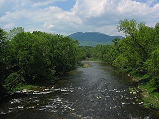
Mount Monadnock, or Grand Monadnock, is a mountain in the New England state of New Hampshire, known for being featured in the writings of Ralph Waldo Emerson and Henry David Thoreau. It is the most prominent mountain peak in southern New Hampshire and is the highest point in Cheshire County. It is located 62 miles (100 km) northwest of Boston and 38 miles (61 km) southwest of Concord, within the towns of Jaffrey and Dublin, New Hampshire. At 3,165 feet (965 m), Mount Monadnock is nearly 1,000 feet (305 m) higher than any other mountain peak within 30 miles (48 km) and rises 2,000 feet (610 m) above the surrounding landscape.

Monadnock Mountain, also called Mount Monadnock, is an inselberg located in Lemington in the Northeast Kingdom region of Vermont in the United States. The mountain overlooks the Connecticut River and the town of Colebrook, New Hampshire.

Pack Monadnock mountain in United States of America

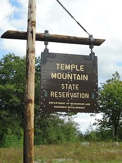
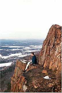
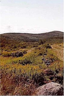
Pack Monadnock or Pack Monadnock Mountain 2,290 feet (700 m), is the highest peak of the Wapack Range of mountains and the highest point in Hillsborough County, New Hampshire. The mountain, a monadnock, is located in south-central New Hampshire within the towns of Peterborough and Temple. The 22 mi (35 km) Wapack Trail and a number of shorter trails traverse the mountain. A firetower and ledges on the summit offer long views north to the White Mountains, west to Mount Monadnock, and south into Massachusetts. North Pack Monadnock Mountain is located directly to the north along the Wapack ridgeline; Temple Mountain to the south.

Hiking trails

Metacomet-Monadnock Trail

The Metacomet-Monadnock Trail is a 114-mile-long (183 km) hiking trail that traverses the Metacomet Ridge of the Pioneer Valley region of Massachusetts and the central uplands of Massachusetts and southern New Hampshire. Although less than 70 miles (110 km) from Boston and other large population centers, the trail is considered remarkably rural and scenic and includes many areas of unique ecologic, historic, and geologic interest. Notable features include waterfalls, dramatic cliff faces, exposed mountain summits, woodlands, swamps, lakes, river floodplain, farmland, significant historic sites, and the summits of Mount Monadnock, Mount Tom and Mount Holyoke. The Metacomet-Monadnock Trail is maintained largely through the efforts of the Berkshire Chapter of the Appalachian Mountain Club (AMC). Much of the trail is a portion of the New England National Scenic Trail.

Monadnock-Sunapee Greenway

The Monadnock-Sunapee Greenway (MSG) is a 50-mile (80 km) hiking trail that traverses the highlands of southern New Hampshire from Mount Monadnock in Jaffrey to Mount Sunapee in Newbury. Located approximately 27 miles (43 km) from the city of Concord, New Hampshire, the trail traverses a rural, heavily glaciated and metamorphic upland studded with lakes, heath barrens, the rocky summits of several monadnocks, and dense woodland of the northern hardwood forest type. The trail is maintained primarily through the efforts of the Monadnock-Sunapee Greenway Trail Club.

Architecture

Monadnock Building Skyscraper on West Jackson Boulevard in Chicago, Illinois

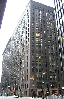
The Monadnock Building is a 16-story skyscraper located at 53 West Jackson Boulevard in the south Loop area of Chicago, Illinois. The north half of the building was designed by the firm of Burnham & Root and built starting in 1891. The tallest load-bearing brick building ever constructed, it employed the first portal system of wind bracing in America. Its decorative staircases represent the first structural use of aluminum in building construction. The south half, constructed in 1893, was designed by Holabird & Roche and is similar in color and profile to the original, but the design is more traditionally ornate. When completed, it was the largest office building in the world. The success of the building was the catalyst for an important new business center at the southern end of the Loop.

The Monadnock Building is an historic 10-story, 204,625 square foot office building in downtown San Francisco, California located at 685 Market St. The building was designed by the firm of Frederick H. Meyer and Smith, and completed in 1907, immediately following the 1906 San Francisco earthquake. The building stands immediately adjacent to both the BART Montgomery Street Station and the Palace Hotel, and across Market Street from Lotta's Fountain.

Business

Monadnock Lifetime Products, Inc. is a weapons manufacturer providing equipment to law enforcement and private security companies since 1958. Monadnock produce several models of police baton. The company is a subsidiary under Safariland, LLC

Ships

USS Monadnock may refer to:

Related Research Articles

Greenfield, New Hampshire Town in New Hampshire, United States

Greenfield is a town in Hillsborough County, New Hampshire, United States. The population was 1,749 at the 2010 census. Greenfield is home to the Crotched Mountain Rehabilitation Center, to Greenfield State Park, and to part of the Wapack Trail.

Wapack Trail

The Wapack Trail is one of the oldest public, interstate hiking trails in the United States. Opened in 1923, it follows the Wapack Range north-south for 21 miles (34 km), between Mount Watatic in Ashburnham, Massachusetts and North Pack Monadnock mountain in Greenfield, New Hampshire. It is designed primarily for day use by hikers, with minimal camping facilities.

Miller State Park

Miller State Park is the oldest state-run park in New Hampshire, a state in the New England region of the United States. It is located in the towns of Peterborough and Temple, and is centered on Pack Monadnock, a 2,290-foot (700 m) mountain..

Mount Ascutney mountain in Vermont, United States of America

Mount Ascutney is a monadnock located in southern Vermont. With a summit elevation of about 3144 feet, it is the second-highest peak in Windsor County, Vermont. Particularly noteworthy about Ascutney are its granite outcrops, one of which, near its peak, serves as a launching point for hang-gliders. The mountain is very steep, and its trails traverse a Vermont state forest.

Mount Kearsarge (Merrimack County, New Hampshire) mountain in United States of America

Mount Kearsarge is a mountain located in Wilmot, New Hampshire, and Warner, New Hampshire. Two state parks are located at the northern and southern bases of the mountain—Winslow State Park and Rollins State Park, respectively—and the entire mountain is within Kearsarge Mountain State Forest. On a very clear day, skyscrapers in the city of Boston 80 miles (130 km) away are visible from the fire tower on the summit. The summit has remained bare since a 1796 forest fire.

Midstate Trail (Massachusetts)

The Midstate Trail is a scenic footpath which runs 92 miles (148 km) through Worcester County, Massachusetts, from the Rhode Island border to the New Hampshire border, approximately 45 miles (72 km) west of Boston. The trail is considered highly accessible, scenic, and remarkably rural despite its proximity to urban Boston. The trail includes the summits of Mount Wachusett and Mount Watatic, as well as many interesting geologic, historic, and natural features.

Mount Watatic mountain in United States of America

Mount Watatic is a 1,832-foot (558 m) monadnock located just south of the Massachusetts–New Hampshire border, in the United States, at the southern end of the Wapack Range of mountains. It lies within Ashburnham and Ashby, in Massachusetts, and New Ipswich, in New Hampshire; the 22 miles (35 km) Wapack Trail and the 92-mile (148 km) Midstate Trail both cross the mountain. The Yellow Arrow trail is 1.1 mile.

Temple Mountain (New Hampshire) New Hampshire

Temple Mountain is a 2,045-foot (623 m) ridge located in south-central New Hampshire within the Wapack Range of mountains. It lies within Sharon and Temple, New Hampshire; the 22-mile (35 km) Wapack Trail traverses the mountain, and the northern face includes the 350-acre (1.4 km2) Temple Mountain Reservation, owned by the state. The mountain is 3.5 miles (5.6 km) long and has several summits; three of them are named: Burton Peak 2,010 feet (610 m), Whitcomb Peak 1,710 feet (520 m), and Holt Peak, the high point.

Little Monadnock Mountain mountain in United States of America

Little Monadnock Mountain, 1,900 feet (579 m), is located in the towns of Fitzwilliam and Troy, New Hampshire. Most of the mountain is located within Rhododendron State Park; there are scenic vistas from ledges just below the summit. The 110 mile Metacomet-Monadnock Trail crosses the mountain.

Gap Mountain mountain in United States of America

Gap Mountain, located in Troy, New Hampshire, United States, is a small monadnock with three summits ranging between 1,820 feet (555 m) and 1,900 feet (579 m) above sea level. The lower north and middle summits are mostly bald and offer panoramic views of the surrounding rural landscape and of the higher and more popular Mount Monadnock. The Metacomet-Monadnock Trail passes over the north and middle peaks. The higher southern summit is wooded with no views. The mountain, located entirely within the Gap Mountain Reservation managed by the Society for the Protection of New Hampshire Forests, is named for the cleft separating the south peak from the north and middle summits.

Wapack Range

The Wapack Range, sometimes referred to as the Pack Monadnock Range, is a 20-mile-long (32 km) range of mountains in south-central New Hampshire and adjacent Massachusetts, in the northeastern United States. The range is considered very scenic and rugged with many bare summits and ledges ranging from 1,800 to 2,290 feet. The 22-mile (35 km) Wapack Trail, one of the oldest interstate hiking trails in the United States, traverses it. The Wapack Range is also the northern terminus of the 90-mile (140 km) Midstate Trail.

North Pack Monadnock mountain in United States of America

North Pack Monadnock or North Pack Monadnock Mountain is a 2,276-foot (694 m) monadnock in south-central New Hampshire, at the northern end of the Wapack Range of mountains. It lies within Greenfield and Temple, New Hampshire; the 22-mile (35 km) Wapack Trail traverses the mountain. Ledges on the summit offer long views north to the White Mountains and west to Mount Monadnock. Pack Monadnock Mountain is directly to the south along the Wapack ridgeline. The upper elevations of the mountain are within Miller State Park.

Kidder Mountain mountain in New Hampshire, United States of America

Kidder Mountain is a 1,805 feet (550 m) summit located in south-central New Hampshire within the Wapack Range of mountains. It lies within New Ipswich and Temple, New Hampshire just off the 22 mi (35 km) Wapack Trail on a 0.9-mile (1.4 km) side trail. Temple Mountain is located directly to the north along the Wapack ridgeline; Barrett Mountain to the south. The summit of the mountain is mostly open and offers expansive views from old pastures.

Barrett Mountain mountain in New Hampshire, United States of America

Barrett Mountain is a mountain located in south-central New Hampshire within the Wapack Range of mountains. It lies within the town of New Ipswich and is traversed by the 22-mile (35 km) Wapack Trail. Kidder Mountain is located directly to the north along the Wapack ridgeline; New Ipswich Mountain to the south. The summit of the mountain is mostly wooded. A cross-country ski area occupies the north side of Barrett Mountain.

New Ipswich Mountain summit in south-central New Hampshire, USA

New Ipswich Mountain is a summit within the Wapack Range of mountains in south-central New Hampshire, United States. It lies within the town of New Ipswich and is traversed by the 22-mile (35 km) Wapack Trail. Barrett Mountain is located directly to the north along the Wapack ridgeline; Stony Top, a subordinate peak of Pratt Mountain, lies to the south. The summit of the mountain is mostly wooded, but a number of rocky ledges below the summit offer views of the surrounding countryside.

Pratt Mountain mountain in New Hampshire, United States of America

Pratt Mountain is a 1,817 feet (554 m) summit within the Wapack Range of mountains in south-central New Hampshire, United States. It lies within the town of New Ipswich and is traversed by the 22 mi (35 km) Wapack Trail. The subordinate peak, Stony Top, 1,760 feet (540 m), forms the north shoulder of the mountain. Pratt Mountain offers expansive views from rocky ledges along its length.

Wapack National Wildlife Refuge

Wapack National Wildlife Refuge is a National Wildlife Refuge of the United States located in southern New Hampshire. It was the state's first refuge and was established through a donation in 1972. The 1,672-acre (677 ha) refuge is located about 20 miles (32 km) west of Nashua, New Hampshire and encompasses the 2,278-foot (694 m) North Pack Monadnock Mountain.