
Russell Island is an uninhabited island of the Canadian Arctic Archipelago in the Qikiqtaaluk Region of Nunavut, Canada. It is located in the Parry Channel, separated from the northern tip of Prince of Wales Island by the narrow Baring Channel. The western third of the island is separated from the other two thirds by a narrow lake and its outlet. At the northern end of the lake there is an isthmus just 1.1 km (0.68 mi) wide and this joins the two parts of the island. With a total area of 940 km2 (360 sq mi), it is the largest island offshore of Prince of Wales Island.

Qikiqtaaluk (ᕿᑭᖅᑖᓗᒃ) formerly White Island is one of the uninhabited Canadian arctic islands in the Kivalliq Region, Nunavut, Canada. Located in Foxe Basin off the northern tip of Southampton Island, it measures 789 km2 (305 sq mi) in area.

Moore Island is an uninhabited island in the Qikiqtaaluk Region, Nunavut, Canada. It is a member of the Belcher Islands group in Hudson Bay. It lies in Churchill Sound between Kugong Island to its west and the Howard Peninsula of Flaherty Island to its east with the Inuit community of Sanikiluaq about 30 km (19 mi) northeast.

Innetalling Island is an uninhabited island in Qikiqtaaluk Region, Nunavut, Canada. Located in Hudson Bay's Omarolluk Sound, it is a member of the Belcher Islands group. It runs from Fairweather Sound at its northern end to Ridge Passage at its southern one. Fairweather Harbour is located on the north end of the island's east side.
Snape Island is an uninhabited island in Qikiqtaaluk Region, Nunavut, Canada. Located in Hudson Bay, it is a member of the Belcher Islands group. It closes Omarolluk Sound on its southwestern side. Rock Passage at its north end separates it from the Mukpollo Peninsula of Flaherty Island, and the Narrow Passage at its southeast end separates it from O'Leary Island.
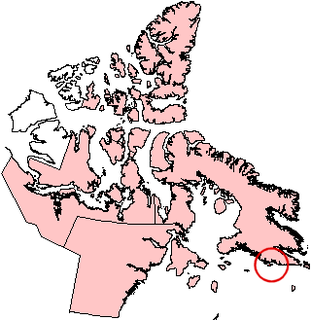
Qikiqtarjuaq formerly Big Island is an uninhabited island located in the Qikiqtaaluk Region, Nunavut, Canada. It lies in Hudson Strait and is separated from Baffin Island by White Strait. The closest community is Kimmirut, 28 km (17 mi) away.
One of the Baffin Island offshore, uninhabited island groups, the Kaigosuiyat Islands are located between Irvine Inlet and Nettilling Fiord, south of Iglunga and southwest of Pangnirtung. They are part of the Qikiqtaaluk Region, in the Canadian territory of Nunavut.
One of the Baffin Island offshore island groups, the uninhabited Trinity Islands are located in Foxe Basin, west of Lonebutte Bay. They are part of the Qikiqtaaluk Region, in the Canadian territory of Nunavut.
The Low Islands are one of the many uninhabited Canadian arctic island groups in Qikiqtaaluk Region, Nunavut. They are located in Ungava Bay, stretching between Young Island to the south and Lookout Island to the north.
One of the uninhabited Baffin Island offshore island groups, the Lavoie Islands are located at the head of the Bernier Bay, approximately 80 km (50 mi) from its opening into eastern Gulf of Boothia. The islands are part of the Qikiqtaaluk Region, in the Canadian territory of Nunavut.
Iglunga Island is an uninhabited island in the Qikiqtaaluk Region of Nunavut, Canada. It is located in Baffin Island's Cumberland Sound, between Kangilo Fiord and Kangerk Fiord. Anarnittuq Island, Clear Passage Island, Imigen Island, Ivisa Island, the Kekertelung Islands, Nunatak Island, and Saunik Island are in the vicinity.
Anarnittuq Island is an uninhabited island in the Qikiqtaaluk Region of Nunavut, Canada. It is located in Baffin Island's Cumberland Sound. It lies at the combined mouths of Clearwater and Shark Fiord, between Clear Passage Island and Kekertelung Island. The Sanigut Islands, Iglunga Island, and Nunatak Island are in the vicinity.

Clear Passage Island is an uninhabited island in the Qikiqtaaluk Region of Nunavut, Canada. It lies in Kangilo Fiord, the southern of Baffin Island's Cumberland Sound's two ends. The False Passage Peninsula lies northwest of the island. Anarnittuq Island, Iglunga Island, and Nunatak Island are in the vicinity.
Nunatak Island is an uninhabited island in the Qikiqtaaluk Region of Nunavut, Canada. It is located at the northern end of Baffin Island's Cumberland Sound, at the junction of Shark Fiord and Clearwater Fiord. Southeast is Kekertelung Island. Anarnittuq Island, Clear Passage Island, and Iglunga Island are also located within this vicinity.
Ney Island is an uninhabited island in Qikiqtaaluk Region, Nunavut, Canada. Located in Hudson Bay, it is a member of the Belcher Islands group. It lies at the northern end of the Kipalu Inlet of Flaherty Island, between the Mukpollo Peninsula to the east and the Gibson Peninsula to the west. Other islands in the immediate vicinity include:
O'Leary Island is an uninhabited island in Qikiqtaaluk Region, Nunavut, Canada. Located in Hudson Bay, it is a member of the Belcher Islands group. It lies at the southeast end of Omarolluk Sound between Ridge Passage to the north and Narrow Passage to its south; Broomfield Island runs parallel to its east side. Other islands in the immediate vicinity include:
Graham Moore may refer to:

Moore Island is an uninhabited island in the Qikiqtaaluk Region, Nunavut, Canada. It lies in Boat Passage, on the northern side of Rupert Bay, an extension of Hudson Bay. It measures about 300 m (980 ft) along its longest axis. Jacob Island lies to the west and Waskaganish is about 31 km (19 mi) southeast.
Moore Island is an uninhabited island in the Qikiqtaaluk Region, Nunavut, Canada. It is a member of the Queen Elizabeth Islands group. It lies in Intrepid Passage, south of Bathurst Island. It measures about 2 km (1.2 mi) along its longest axis.
Moore Island is an uninhabited island in Qikiqtaaluk Region, Nunavut, Canada. It is a member of the Hopewell Islands group in Hudson Bay. It lies in Hopewell Sound, about 28 km (17 mi) northwest of Inukjuak, Quebec, between McCormack Island and Hopkins Island. It measures about 4 km (2.5 mi) along its longest axis.