Related Research Articles
The Keltie Glacier is a large Antarctic glacier, 30 nautical miles (56 km) long, draining from Pain Névé southwest around the southern extremity of the Commonwealth Range, and then northwest to enter Beardmore Glacier at Ranfurly Point. It was discovered by the British Antarctic Expedition, 1907–09, under Ernest Shackleton, who named it for Sir John Scott Keltie, Secretary of the Royal Geographical Society, 1892–1915.

The Darwin Glacier is a large glacier in Antarctica. It flows from the polar plateau eastward between the Darwin Mountains and the Cook Mountains to the Ross Ice Shelf. The Darwin and its major tributary the Hatherton are often treated as one system, the Darwin–Hatherton.
The Aviator Glacier is a major valley glacier in Antarctica that is over 60 nautical miles long and 5 nautical miles wide, descending generally southward from the plateau of Victoria Land along the west side of Mountaineer Range, and entering Lady Newnes Bay between Cape Sibbald and Hayes Head where it forms a floating tongue.
The Alma River is in Marlborough, New Zealand. It flows through rugged inland terrain before meeting the Severn River not far from where the Severn meets the Acheron River.
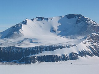
Mount Joyce is a prominent, dome-shaped mountain, 1,830 metres (6,000 ft) high, standing 8 nautical miles (15 km) northwest of Mount Howard in the Prince Albert Mountains of Victoria Land, Antarctica.
Coldstream River, a watercourse of the Clarence River catchment, is located in the Northern Rivers district of New South Wales, Australia.
Yarrow River, a perennial stream of the Clarence River catchment, is located in the Northern Tablelands district of New South Wales, Australia.
The Hororata River is a river of Canterbury, in the South Island of New Zealand. A tributary of the Selwyn River, the Hororata has its sources in rough hill country north of Windwhistle, and flows east through the township of Hororata before reaching the Selwyn 12 kilometres (7 mi) northwest of Dunsandel.
The Jackson River is a river of the southwestern South Island of New Zealand. It flows predominantly northeast, flowing into the Arawhata River close to the latter's outflow into Jackson Bay.
The Kaeo River is a river of the far north of New Zealand's North Island. It flows through the north of the North Auckland Peninsula, reaching the sea at the Whangaroa Harbour. The small town of Kaeo sits on its banks, 5 kilometres (3 mi) from the river's mouth.
The Little Akatarawa River is a river of the Wellington Region of New Zealand's North Island. It is a tributary of the Akatarawa River, which it meets 5 kilometres (3 mi) northwest of Te Mārua.
The Little Lottery River is a river of the northeast of New Zealand's South Island. It flows southwest through the Amuri Range, flowing into the Lottery River, part of the Waiau River system.
The Otto River is a short river of the West Coast Region of New Zealand's South Island. It is one of the headwaters of the Grey River.
The Phantom River is a river of the Canterbury region of New Zealand's South Island. It flows predominantly east from the ben McLeod Range north of Fairlie to reach the Orari River 20 kilometres (12 mi) northwest of Peel Forest.
The Pupuke River is a river of the Northland Region of New Zealand's North Island. It flows northeast to reach the southern end of Whangaroa Harbour 5 miles (8 km) northwest of Kaeo.
The Barton Mountains are a group of mountains located south of the Commonwealth Range and the Hughes Range and bounded by Keltie Glacier, Brandau Glacier, Leigh Hunt Glacier, and Snakeskin Glacier, in the Queen Maud Mountains.
Salamander Range is a distinctive linear range between Canham Glacier and Black Glacier, in the Freyberg Mountains, Antarctica. The range was named by the Northern Party of New Zealand Geological Survey Antarctic Expedition (NZGSAE), 1963–64, from the nickname given to Lord Freyberg by Sir Winston Churchill, for the lizard that is untouched by fire.
Blue Glacier is a large glacier which flows into Bowers Piedmont Glacier about 10 nautical miles south of New Harbour, in Victoria Land, Antarctica. It was discovered by the British National Antarctic Expedition (BrNAE) under Robert Falcon Scott, 1901–04, who gave it this name because of its clear blue ice at the time of discovery.

Motunau Island is a small, 3 ha, island nature reserve lying 1.2 km (0.75 mi) off the coast of New Zealand's South Island, at the northern end of Pegasus Bay, south of the mouth of the Motunau River. The reserve is managed by the Department of Conservation and access is by permit only.
References
"Place name detail: Motunau River". New Zealand Gazetteer. New Zealand Geographic Board . Retrieved 12 July 2009.
43°03′S173°05′E / 43.050°S 173.083°E