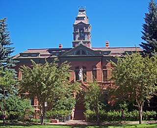
Pitkin County is a county in the U.S. state of Colorado. As of the 2020 census, the population was 17,358. The county seat and largest city is Aspen. The county is named for Colorado Governor Frederick Walker Pitkin.

Gunnison County is a county located in the U.S. state of Colorado. As of the 2020 census, the population was 16,918. The county seat is Gunnison. The county was named for John W. Gunnison, a United States Army officer and captain in the Army Topographical Engineers, who surveyed for the transcontinental railroad in 1853.

Mt. Crested Butte is a home rule municipality in Gunnison County, Colorado, United States. Mount Crested Butte is the home of the Crested Butte Mountain Resort. The population was 941 at the 2020 census. ZIP code 81225 serves post office boxes for Mount Crested Butte and for neighboring Crested Butte; mail must be addressed to Crested Butte.

Pitkin is a Statutory Town in Gunnison County, Colorado, United States. The population was 72 at the 2020 census.
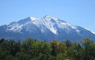
Mount Sopris is a twin-summit mountain in the northwestern Elk Mountains range of the Rocky Mountains of North America. The prominent 12,965-foot (3,952 m) mountain is located in the Maroon Bells-Snowmass Wilderness of White River National Forest, 6.6 miles (10.7 km) north by northeast of the community of Redstone in Pitkin County, Colorado, United States.

The Collegiate Peaks Wilderness is a 168,000-acre (680 km2) area located in central Colorado between Leadville and Buena Vista to the east and Aspen to the west and Crested Butte to the southwest. Most of the area is in the San Isabel and Gunnison National Forests, with a smaller area in the White River National Forest southeast of Aspen. Most of the area is in northwest Chaffee County with smaller portions in Gunnison, Pitkin, and Lake counties.

White River National Forest is a National Forest in northwest Colorado. It is named after the White River that passes through its northern section. It is the most visited National Forest in the United States, primarily from users of the twelve ski areas within its boundaries.

Uncompahgre National Forest is a U.S. National Forest covering 955,229 acres in parts of Montrose, Mesa, San Miguel, Ouray, Gunnison, Hinsdale, San Juan, and Delta Counties in western Colorado. Its headquarters are in Delta County, in the city of Delta. It borders the San Juan National Forest to the south.
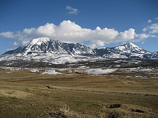
Mount Lamborn is a mountain summit in the West Elk Mountains range of the Rocky Mountains of North America. The 11,402-foot (3,475 m) peak is located in Gunnison National Forest, 5.9 miles (9.5 km) southeast by south of the Town of Paonia in Delta County, Colorado, United States. The summit of Mount Lamborn is the highest point in Delta County. Together with nearby Landsend Peak to the southwest, it lies at the western edge of the West Elks, rising dramatically nearly 6,000 ft above the valley of the North Fork Gunnison River to the west.
Mount Emmons may refer to:

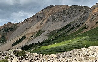
Henry Mountain is a high and prominent mountain summit in the southern Sawatch Range of the Rocky Mountains of North America. The 13,261-foot (4,042 m) thirteener is located in the Fossil Ridge Wilderness of Gunnison National Forest, 7.8 miles (12.5 km) northwest of the Town of Pitkin in Gunnison County, Colorado, United States.
Mount Gunnison is a prominent mountain summit in the West Elk Mountains range of the Rocky Mountains of North America. The 12,725-foot (3,879 m) peak is located in the West Elk Wilderness of Gunnison National Forest, 22.2 miles (35.7 km) west by south of the Town of Crested Butte in Gunnison County, Colorado, United States. The mountain is named in honor of John Williams Gunnison who explored the area.

Mount Guero is a prominent mountain summit in the West Elk Mountains range of the Rocky Mountains of North America. The 12,058-foot (3,675 m) peak is located in the West Elk Wilderness of the Gunnison National Forest, 13 miles (21 km) east of Crawford, Colorado in Delta County and 24.3 miles (39.1 km) west-southwest of the Town of Crested Butte in Gunnison County, Colorado, United States.

Mount Owen is the highest summit of the Ruby Range of the Rocky Mountains of North America. The 13,070-foot (3,984 m) thirteener is located in Gunnison National Forest at the edge of the Raggeds Wilderness, 8.5 miles (13.6 km) west-northwest of the Town of Crested Butte in Gunnison County, Colorado, United States.
Mount Emmons is a mountain summit in the Elk Mountains range of the Rocky Mountains in north-central Gunnison County, Colorado, United States.
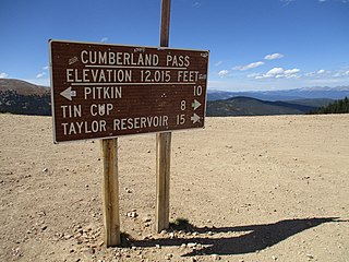
Cumberland Pass is a high mountain pass in the Sawatch Range of the Rocky Mountains of Colorado. It is located in Gunnison County and in the Gunnison National Forest. The pass divides the watersheds of West Willow Creek to the north and Quartz Creek to the south.

The West Elk Loop Scenic and Historic Byway is a 205-mile (330 km) National Forest Scenic Byway and Colorado Scenic and Historic Byway located in Delta, Garfield, Gunnison, Montrose, and Pitkin counties Colorado, USA. The byway reaches its zenith at Kebler Pass, elevation 10,007 feet (3,050 m), between Crested Butte and Paonia.
Mount Daly is a mountain summit in Pitkin County, Colorado, United States.
Mount Daly is a mountain summit in Gunnison County, Colorado, United States.