
Mount Hood Parkdale is the official United States Postal Service-designated name of the combined post offices of the communities of Mount Hood and Parkdale in the U.S. state of Oregon. [1] Its ZIP code is 97041. [1]
Mount Hood Parkdale is the official United States Postal Service-designated name of the combined post offices of the communities of Mount Hood and Parkdale in the U.S. state of Oregon. [1] Its ZIP code is 97041. [1]

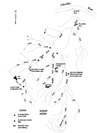
Hood River County is one of the 36 counties in the U.S. state of Oregon. As of the 2020 census, the population was 23,977. The county seat is Hood River. The county was established in 1908 and is named for the Hood River, a tributary of the Columbia River. Hood River County comprises the Hood River, OR Micropolitan Statistical Area. The Hood River Valley produces apples, pears, and cherries. Situated between Mount Hood and the Columbia River in the middle of the Columbia River Gorge, Hood River County is a popular destination for outdoor enthusiasts, such as windsurfers, mountain-bikers, skiers, hikers, kayakers, and many more.

Parkdale is an unincorporated community and census-designated place (CDP) in Hood River County, Oregon, United States. As of the 2010 census, the population was 311, up from 266 at the 2000 census.

Mount Hood is an unincorporated community and census-designated place (CDP) in Hood River County, Oregon, United States, about 3 miles (5 km) northeast of Parkdale on Oregon Route 35. As of the 2010 census it had a population of 286. Mount Hood is the terminus of Oregon Route 281, the Hood River Highway.
The Dog River is a small river in Oregon's Cascade Range and drains a few eastern foothills of Mount Hood. It is a tributary of East Fork Hood River and also contributes water for The Dalles and Hood River water systems. It is approximately 8 miles (14 km) long and drains the most southeastern portion of the Hood River watershed.

The Columbia Gorge AVA is an American Viticultural Area which includes land surrounding the Columbia River Gorge, straddling the border between Oregon and Washington. Due to the significant gradations of climate and geography found in the gorge, this AVA exhibits a wide range of terroir in a relatively small region; it is marketed as a "world of wine in 40 miles".

Snow Bunny is a small snow play area in Mount Hood National Forest on the south face of Mount Hood in Oregon, United States, about 65 miles (105 km) east of Portland. Inner tubing, tobogganing and other snow sports are on a maintained 20-foot (6.1 m) to 30-foot (9.1 m) hill of snow, popular with young children and families. It was established in 1952 as Mount Hood's first snow play area for children.
Elk Cove is a meadow in the Mount Hood Wilderness on the north side of Mount Hood in the U.S. state of Oregon. It is a popular backpacking area along the Timberline Trail.

Sheridan State Scenic Corridor is a state park in the Columbia River Gorge, west of Cascade Locks, Oregon. The 11-acre (4.5 ha) property, containing an old-growth forest, is located on the south side of Interstate 84 at approximately milepoint 42.5, and was not accessible by motor vehicle since I-84 was built in 1960. However, with the opening of the Eagle Creek-Cascade Locks segment of the Historic Columbia River Highway State Trail in 1998, it has become easily accessible by foot or bicycle. The park is on a triangular lot, surrounded by I-84 and the Mount Hood National Forest.
Dee is an unincorporated community and former company town in Hood River County, Oregon, United States, on Oregon Route 281, about 11 miles south of Hood River.
Bull Run National Forest was established as the Bull Run Forest Reserve by the General Land Office in Oregon on June 17, 1892, with 142,080 acres (575.0 km2). After the transfer of federal forests to the U.S. Forest Service in 1905, it became a National Forest on March 4, 1907. On July 1, 1908, the entire forest was combined with part of Cascade National Forest to establish Oregon National Forest and the name was discontinued. The lands are now part of Mount Hood National Forest.
Timberline Trail is a hiking trail around Mount Hood in the U.S. state of Oregon. It is mostly in wilderness but also goes near Timberline Lodge, Cloud Cap Inn, and Mount Hood Meadows ski area.
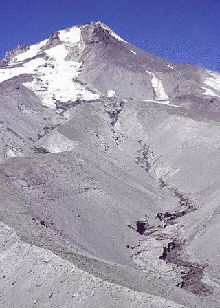
White River Glacier is an alpine glacier located on the south slopes of Mount Hood in the U.S. state of Oregon. It ranges in elevation from about 10,000 to 6,200 feet. It is among the best known of the twelve glaciers on the mountain, and the lower reaches are a popular destination for Nordic skiing enthusiasts. The glacier is the source of the White River, a tributary of the Deschutes River, and has a long history of washing out the bridge where Oregon Route 35 crosses at 45.30307°N 121.67208°W.
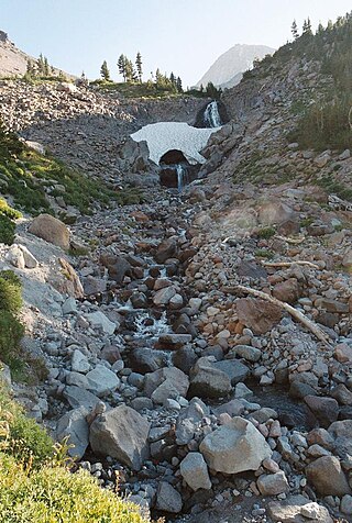
Wy'east Falls is a waterfall on a small tributary of Eagle Creek in Hood River County, Oregon, U.S.

Eagle Creek is a tributary of the Columbia River in Multnomah and Hood River counties in the U.S. state of Oregon. It cuts through a narrow canyon in its 3,200 feet (980 m) descent to the Columbia River Gorge and is known for its concentration of 13 waterfalls in about 5 miles (8.0 km) distance. Eight major falls are on Eagle Creek and the East Fork Eagle Creek itself, while five are on its tributaries.
Lenz is an unincorporated community in Hood River County, Oregon, United States just west of Oregon Route 35 about a mile and a half east of Odell. This station on the Mount Hood Railroad was named after John Lenz, an early settler. Lenz Butte and Lenz Creek are nearby. The name of the station has also been spelled Lentz and was also known as "Sherman Spur". The elevation is 732 feet.
Bloucher is an unincorporated historic community west of Odell in Hood River County, Oregon, United States.
Hood River Valley is the river basin of Hood River in northern Oregon, U.S. It is bounded by the Columbia River to the north, Mount Hood to the south, the Cascade Range crest to the west and an apparently unnamed ridge system to the east which contains Hood River Mountain and Snyder Canyon. Mount Hood National Forest surrounds the Hood River Valley west, south, and east. It is entirely contained in Hood River County.
Faubion is an unincorporated community in Clackamas County, Oregon, United States. It is located about 2 miles northwest of Rhododendron, in the Mount Hood Corridor on a loop road off U.S. Route 26 near the Zigzag River.

Wildwood is an unincorporated community in Clackamas County, Oregon, United States. It is located in the Mount Hood Corridor about 2.5 miles southeast of Brightwood, along U.S. Route 26 near the Sandy River. Wildwood, which is outside any urban growth boundary, is located in a rural area of concentrated residential development that includes both primary and vacation residences, a few commercial facilities, including a tavern, and outdoor recreational areas, including the Wildwood Recreation Site.
45°31′11″N121°35′48″W / 45.519839°N 121.596742°W
| | This Hood River County, Oregon state location article is a stub. You can help Wikipedia by expanding it. |