This page is based on this
Wikipedia article Text is available under the
CC BY-SA 4.0 license; additional terms may apply.
Images, videos and audio are available under their respective licenses.

County Tipperary is a county in Ireland. It is located in the province of Munster. The county is named after the town of Tipperary, and was established in the early thirteenth century, shortly after the Norman invasion of Ireland. The population of the county was 159,553 at the 2016 census. The largest towns are Clonmel, Nenagh and Thurles.

North Tipperary was a county in Ireland. It was part of the Mid-West Region and was also located in the province of Munster. It was named after the town of Tipperary and consisted of 48% of the land area of the traditional county of Tipperary. North Tipperary County Council was the local authority for the county. In 2011, the population of the county was 70,322. It was abolished on 3 June 2014, merged with South Tipperary under a new Tipperary County Council.

Littleton is a village in County Tipperary, Ireland. It is within the townlands of Ballybeg and Ballydavid, about 18 km (11 mi) northeast of Cashel and to the southeast of Thurles. By-passed by the M8 in December 2008, Littleton lies at a crossroads on the R639 road. Its population was 463 at the 2006 census. It is in the barony of Eliogarty.

Rossmore is a small village and townland in County Tipperary in Ireland. It is in the civil parish of Clonoulty, barony of Kilnamanagh Lower. It is located in the District Electoral Division (DED) of Clonoulty West. It is also half of the Clonoulty and Rossmore parish in the Roman Catholic Archdiocese of Cashel and Emly.

Ballingarry is a civil parish and a townland in the barony of Ormond Lower, County Tipperary in Ireland. It is located on the N52 between Borrisokane and Birr.
Monsea is a townland in the Barony of Ormond Lower. It is also a civil parish in the Baronies of Ormond Lower and Owney and Arra in County Tipperary, Ireland. Nine of the townlands within the civil parish are located in Ormond Lower with three townlands located in Owney and Arra.

Parkstown is a townland in County Tipperary in Ireland. Occupying 624 acres, it is located in the civil parish of Ballymoreen in the barony of Eliogarty in the poor law union of Thurles.

Moycarkey, Littleton, Two-Mile-Borris is an ecclesiastical parish in the Cashel deanery of the Roman Catholic Archdiocese of Cashel and Emly. There are three churches in the parish:

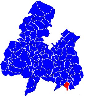
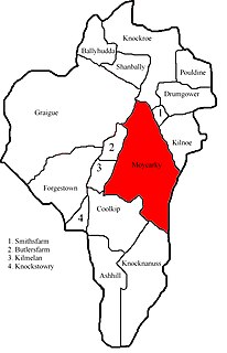
Moycarkey is an electoral division in County Tipperary in Ireland. It was originally an electoral division in the Thurles Poor Law Union in North Tipperary but is still used for various administrative purposes.

Thurles Poor Law Union, which was officially declared on 28 March 1839, covered an area of 195 square miles, mostly in North Tipperary but also including some of South Tipperary. Although the boundaries of some poor law unions changed during the course of the 19th century, the Thurles union seems to have retained its original boundaries.

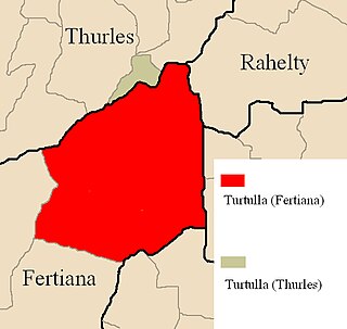
Turtulla is a townland in the civil parish of Fertiana, County Tipperary.
It is a little over 790 acres in extent and is bounded on its northern edge by the River Suir, which separates it from another, much smaller, townland of the same name, which belongs to Thurles civil parish.

Littleton is an electoral division in County Tipperary in Ireland.
The code number assigned it by the Central Statistics Office is 22071.

Rahealty, or Rahelty, is an electoral division in County Tipperary in Ireland.
Knockroe is a townland containing a little over 363 acres in Moycarky civil parish and in the ecclesiastical parish of Moycarkey, Littleton, Two-Mile-Borris, in County Tipperary, Ireland.

Delvin is a barony in north-east County Westmeath, in the Republic of Ireland. It was formed by 1672. It is bordered by County Meath to the east and three other baronies: Fore, Moyashel and Magheradernon and Farbill. The largest centre of population is Delvin.

Tybroughney, statutory spelling Tibberaghny, is a civil parish in the barony of Iverk, County Kilkenny in Ireland. The parish comprises a single townland, also called Tibberaghny. It lies on the north bank of the River Suir facing County Waterford, while the Lingaun river separates it from County Tipperary to the west.


