
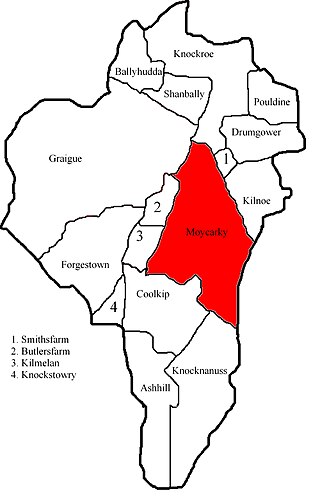
Moycarkey is an electoral division in County Tipperary in Ireland. It was originally an electoral division in the Thurles Poor Law Union in North Tipperary [1] [2] but is still used for various administrative purposes.
Moycarkey is an electoral division in County Tipperary in Ireland. It was originally an electoral division in the Thurles Poor Law Union in North Tipperary [1] [2] but is still used for various administrative purposes.
From the beginning, for reasons which are explained below, an electoral division which had the same name as a civil parish was not necessarily co-extensive with the civil parish. At the time of the 2011 census, the Moycarkey electoral division was co-extensive with the civil parish of the same name. [3] However, this may not have been the case in 1848; the properties listed in a poor law rate document [4] which is dated October 1948 and which seems to be about Moycarkey electoral division include several townlands that are not in Moycarky civil parish, specifically:
However, at the time of the 1911 census, the electoral division was co-extensive with the civil parish. The census returns for the division listed households [5] [6] exactly the townlands in the civil parish, showing that all of them except Smithsfarm which, probably because of its small size (just over 18 acres), did not contain any dwelling - indeed, none is shown on either this Ordnance Survey map or this one.
On 3 October 1848, Vernon Lanphier of Parkstown in Ballymoreen civil parish was elected as rate collector for Moycarkey electoral division of Thurles Poor Law Union. [7] Shortly thereafter, in 1849, the Poor Law Commissioners dissolved the Thurles Board of Guardians, using their power to dissolve any board that was "failing to provide sufficient funds, or to apply them efficiently in relieving the destitute" and to install their own officers. [8]
The population of the division in the 1996 census was 520 and, in 2002, 533 (of which 271 were male and 262 female). [9]
Its population in 2011 was 549, of which males numbered 281 and females were 268. Probably a reflection of the immigration from Eastern Europe to Ireland which had happened in the so-called "Celtic Tiger" period, two of these residents had been born in Poland. The total housing stock was 197, of which 13 were vacant. [10]
When, on the basis of the Poor Law Act (enacted on 31 July 1838), Ireland was divided into Poor Law Unions (by 1847 there were 130 unions, some of which were divided later so that, by 1864, there were 163 unions), the areas used for electing member of the boards of guardians were not, as in England and Wales, civil parishes; instead, electoral divisions were formed by the agglomeration of townlands.) The boundaries of these divisions were drawn by a Poor Law Boundary Commission, the aim being to produce areas of roughly equal rateable value and population. This meant that, while the divisions were almost always contiguous areas, they might have little relation to natural community boundaries. Similarly, the boundaries of the poor law unions themselves often had no relation to those of counties, baronies or civil parishes.[ citation needed ]
The boundaries of these electoral divisions have largely remained unchanged since the nineteenth century, so their populations vary widely, ranging from 32,305 for the electoral division of Blanchardstown-Blakestown in Fingal to 16 for the electoral divisions of Arigna in County Leitrim and Lackagh in North Tipperary (figures from the 2006 Census of Population).
The terms for these divisions has changed over time. Over time, it has become district electoral division. Under section 23 of the Local Government Act 1994, they were termed electoral divisions. There are 3,440 divisions in the republic and they are the smallest administrative area for which population statistics are published). [11]

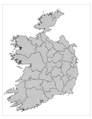
County Tipperary is a county in Ireland. It is in the province of Munster and the Southern Region. The county is named after the town of Tipperary, and was established in the early 13th century, shortly after the Norman invasion of Ireland. It is Ireland's largest inland county and shares a border with eight counties, more than any other. The population of the county was 159,553 at the 2016 census. The largest towns are Clonmel, Nenagh and Thurles.

North Tipperary was a county in Ireland. It was part of the Mid-West Region and was also located in the province of Munster. It was named after the town of Tipperary and consisted of 48% of the land area of the traditional county of Tipperary. North Tipperary County Council was the local authority for the county. In 2011, the population of the county was 70,322. It was abolished on 3 June 2014, merged with South Tipperary under a new Tipperary County Council.
An electoral division is a legally defined administrative area in the Republic of Ireland, generally comprising multiple townlands, and formerly a subdivision of urban and rural districts. Until 1996, EDs were known as district electoral divisions in the 29 county council areas and wards in the five county boroughs. Until 1972, DEDs also existed in Northern Ireland. The predecessor poor law electoral divisions were introduced throughout the island of Ireland in the 1830s. The divisions were used as local-government electoral areas until 1919 in what is now the Republic and until 1972 in Northern Ireland.
A poor law union was a geographical territory, and early local government unit, in the United Kingdom and Ireland.
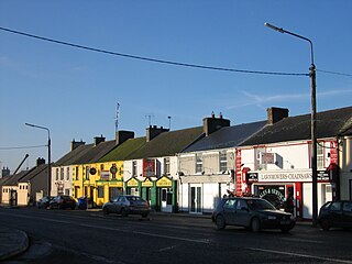
Littleton is a village in County Tipperary, Ireland. It is within the townlands of Ballybeg and Ballydavid, about 18 km (11 mi) northeast of Cashel and to the southeast of Thurles. By-passed by the M8 in December 2008, Littleton lies at a crossroads on the R639 road. Its population was 394 at the 2016 census. It is in the barony of Eliogarty.
The Irish Poor Laws were a series of Acts of Parliament intended to address social instability due to widespread and persistent poverty in Ireland. While some legislation had been introduced by the pre-Union Parliament of Ireland prior to the Act of Union, the most radical and comprehensive attempt was the Irish act of 1838, closely modelled on the English Poor Law of 1834. In England, this replaced Elizabethan era legislation which had no equivalent in Ireland.

Civil parishes are units of territory in the island of Ireland that have their origins in old Gaelic territorial divisions. They were adopted by the Anglo-Norman Lordship of Ireland and then by the Elizabethan Kingdom of Ireland, and were formalised as land divisions at the time of the Plantations of Ireland. They no longer correspond to the boundaries of Roman Catholic or Church of Ireland parishes, which are generally larger. Their use as administrative units was gradually replaced by Poor Law Divisions in the 19th century, although they were not formally abolished. Today they are still sometimes used for legal purposes, such as to locate property in deeds of property registered between 1833 and 1946.

Parkstown is a townland in County Tipperary in Ireland. Occupying 624 acres, it is located in the civil parish of Ballymoreen in the barony of Eliogarty in the poor law union of Thurles.

Moycarkey, Littleton, Two-Mile-Borris is an ecclesiastical parish in the Cashel deanery of the Roman Catholic Archdiocese of Cashel and Emly. There are three churches in the parish:
Moycarkey is a hamlet in North Tipperary, Ireland.
Moycarky is a townland in the civil parish of the same name and in the ecclesiastical parish of Moycarkey, Littleton, Two-Mile-Borris, in County Tipperary, Ireland.

Thurles Poor Law Union, was an Irish Poor law union officially declared on 28 March 1839. It covered an area of 195 square miles (510 km2), mostly in North Tipperary but also including some of South Tipperary. Although the boundaries of some poor law unions changed during the course of the 19th century, the Thurles union seems to have retained its original boundaries.
Thurles is a town in North Tipperary.
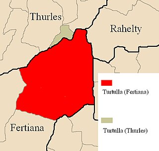
Turtulla is a townland in the civil parish of Fertiana, County Tipperary. It is a little over 790 acres in extent and is bounded on its northern edge by the River Suir, which separates it from another, much smaller, townland of the same name, which belongs to Thurles civil parish.

Buolick is a civil parish in County Tipperary, Ireland. It is one of nineteen civil parishes in the barony of Slievardagh. Buolick, also sometimes written as Boolick or Baolick, is also an electoral division in County Tipperary. The electoral division, originally in the Thurles Poor Law Union, is largely coterminous with Buolick civil parish. The village of Gortnahoo lies within the civil parish.

Littleton is an electoral division in County Tipperary in Ireland. The code number assigned it by the Central Statistics Office is 22071.

Originally called Burris poor law electoral division, and sometimes called Borrisleigh in the past, this electoral division in County Tipperary in Ireland is now known as Twomileborris.

Rahealty, or Rahelty, is an electoral division in County Tipperary in Ireland.
Knockroe is a townland containing a little over 363 acres in Moycarky civil parish and in the ecclesiastical parish of Moycarkey, Littleton, Two-Mile-Borris, in County Tipperary, Ireland.

Garraun is a townland, containing a little over 567 acres, in Twomileborris civil parish in County Tipperary.