A townland is a small geographical division of land, historically and currently used in Ireland and in the Western Isles in Scotland, typically covering 100–500 acres (40–202 ha). The townland system is of Gaelic origin, pre-dating the Norman invasion, and most have names of Irish origin. However, some townland names and boundaries come from Norman manors, plantation divisions, or later creations of the Ordnance Survey. The total number of inhabited townlands in Ireland was 60,679 in 1911. The total number recognised by the Irish Place Names database as of 2014 was 61,098, including uninhabited townlands, mainly small islands.
Twomileborris is a civil parish in the barony of Eliogarty, County Tipperary.
Bornacoola is an ecclesiastical parish in the Roman Catholic Diocese of Ardagh and Clonmacnoise, Ireland. It is located at the southern extremity of County Leitrim in the civil parish of Mohill. Some of its townlands lie in neighbouring County Longford. The nearest large towns are Longford and Carrick-on-Shannon.
Moycarkey, sometimes written Moycarky, is a village at the northern end of Moycarky townland in the civil parish of Moycarky in County Tipperary, Ireland.

Parkstown is a townland in County Tipperary in Ireland. Occupying 624 acres, it is located in the civil parish of Ballymoreen in the barony of Eliogarty in the poor law union of Thurles.
Ballymoreen, or Ballymurreen, is a townland in the civil parish of the same name in County Tipperary in Ireland. It is within the historical barony of Eliogarty in the south-east corner of North Tipperary, between Littleton and Horse and Jockey. Evidence of ancient settlement in Ballymurreen include a number of ringfort sites, a ruined church and graveyard dating to at least the 17th century, and the former site of a tower house and bawn. The townland, which is 1.3 square kilometres (0.5 sq mi) in area, had a population of 65 as of the 2011 census.
Rathcunikeen or Rathcumrikeen is a townland in the civil parish of Ballymurreen, County Tipperary in Ireland. It is an exclave of the parish, as it is surrounded by the neighbouring civil parish of Two-Mile-Borris.

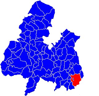
Littleton is an electoral division in County Tipperary in Ireland. The code number assigned it by the Central Statistics Office is 22071.
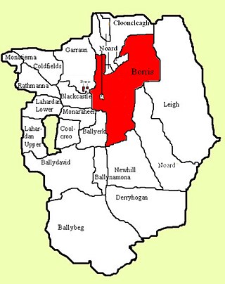
Borris is a townland comprising a little over 1,327 acres in the civil parish of Twomileborris in County Tipperary, Ireland. At the time of the 1891 census, it had a population of 212; in 1891 this had fallen to 175 but had risen again to 190 at the time of the 1911 census.
Rathmanna is a townland containing just over 45 acres in Rahelty civil parish in County Tipperary. It should not be confused with the much larger townland of the same name just across the border in Borrisleigh civil parish.
Rathmanna is a townland containing just over 240 acres in Borrisleigh civil parish in County Tipperary. It should not be confused with the much smaller townland of the same name just across the border in Rahelty civil parish.
Coolkerry is a civil parish in the barony of Clarmallagh in County Laois. It is separated into two disjoint areas by an arm of Aghaboe civil parish.
Coolkerry is a townland in Coolkerry civil parish in County Laois.

Shyane is a civil parish in County Tipperary, Ireland. It is one of 21 civil parishes in the historical barony of Eliogarty. It is divided into three townlands: Clobanna, Rossestown and Coolgarrane.

Abington is a townland in the civil parish of Abington in County Limerick, Ireland. The ruins of the mediaeval Abbey of Woney are located in the local graveyard. The local Church of Ireland church, Saint John's church, designed by James Rawson Carroll and built in 1869, is in the Diocese of Limerick and Killaloe.

Rathgarve, is a civil parish, religious parish, and townland, in County Westmeath, Ireland. It is located about 19.24 kilometres (12 mi) north of Mullingar. It takes in parts of the modern town of Castlepollard, and it forms part of the religious parish of St. Michael's Parish, Castlepollard. Historically it has been linked to the 8th century monk Dicuil, according to Monasticon Hibernicum. However, he is also associated with Rathgar, in Dublin, which may indicate a misassociation with one of these sites.

Castletown, is a townland of County Kerry, Ireland.
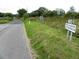
Cartronnagilta is a townland in the civil parish of Templeport, County Cavan, Ireland. It lies in the Roman Catholic parish of Corlough and barony of Tullyhaw. The local pronunciation is Carthoonnaghilta.
Ballinard is a civil parish and townland located in the eastern part of County Limerick, Ireland. The civil parish is part of the barony of Smallcounty. The largest population centre is the village of Herbertstown. The south-eastern part of the parish borders the parish of Kilcullane. Geologically, the parish rests on a substratum of limestone, except in some few places where the basalt rises.


