A townland is a small geographical division of land, historically and currently used in Ireland and in the Western Isles in Scotland, typically covering 100–500 acres (40–202 ha). The townland system is of Gaelic origin, pre-dating the Norman invasion, and most have names of Irish origin. However, some townland names and boundaries come from Norman manors, plantation divisions, or later creations of the Ordnance Survey. The total number of inhabited townlands in Ireland was 60,679 in 1911. The total number recognised by the Irish Place Names database as of 2014 was 61,098, including uninhabited townlands, mainly small islands.
Griffith's Valuation was a boundary and land valuation survey of Ireland completed in 1868.

Binghamstown is a townland and village in County Mayo, Ireland. It lies on the R313 regional road on the Mullet Peninsula, near the town of Belmullet. The townland of Binghamstown has an area of approximately 3 square kilometres (1 sq mi), and had a population of 106 people as of the 2011 census. Binghamstown is in the electoral division of An Geata Mór Thuaidh.

Cregg Mill is a converted 18th-century watermill in the townland of Cregg, near Corrandulla village in County Galway, Ireland, approximately 9 miles (14 km) from Galway City. The mill serviced the local area, including neighbouring Cregg Castle, and served as a feeding centre for the poor of Corrandulla during the Great Famine. An advertisement in the early twentieth century shows that wheat, rye, corn, oats, and barley were kiln-dried and ground there.
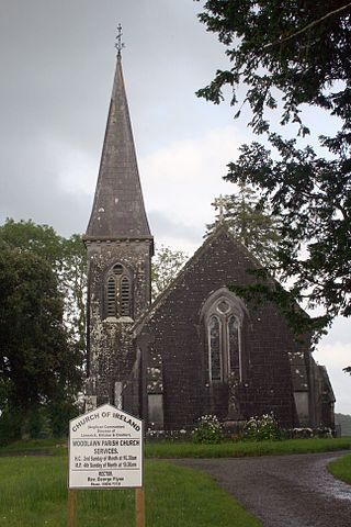
Woodlawn, historically known as Mota or Moote, is a settled area in County Galway, Ireland.

Brickens, officially Brickeens, is a village and townland on the N60 road between Ballyhaunis and Claremorris in southeast County Mayo in Ireland. The River Robe flows through the village which is 65 metres above sea level, and old ordnance survey maps show the townland with an area of 368 acres and 23 perches – equivalent to nearly 150 hectares.

Parkstown is a townland in County Tipperary in Ireland. Occupying 624 acres, it is located in the civil parish of Ballymoreen in the barony of Eliogarty in the poor law union of Thurles.
Kilbrickane is a relatively small townland, measuring just over 78 hectares, in the civil parish of Loughmoe East, County Tipperary. The townland is 2 km (1.2 mi) from the village of Loughmore, 4 km (2.5 mi) from Templemore and 8 km (5.0 mi) from Thurles.
Inch is a townland of a little over 199 acres in the civil parish of the same name, in the barony of Eliogarty, County Tipperary.

Newtown Castle is a 16th-century tower house, located close to the village of Ballyvaughan within the Burren area of County Clare, Ireland. Uniquely for a tower house of its type in Ireland, Newtown Castle is mostly cylindrical in shape but rises from a square pyramidical base. It is today part of the Burren College of Art.
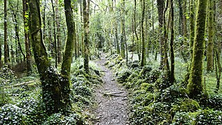
Dromore, County Clare is a rural townland in County Clare in the Republic of Ireland. It is located in the parish of Ruan and was formerly the location of Dromore House. Today, most of the townland is accounted for by Dromore Wood Nature Reserve. It is open to the public and also contains the ruins of Dromore Castle.

Aghavrin House is a country house in the townland of Aghavrin, situated 4.8 km (3.0 mi) north-west of Coachford village in County Cork, Ireland. The 'Big House' and demesne were dominant features in the rural landscape of Ireland, throughout the eighteenth and nineteenth centuries. Location often reflected the distribution of better land, and this is evidenced in mid-Cork, where many of these houses are situated along the valley of the River Lee and its tributaries.
St Olan's is a residence in Aghavrin townland, 4.2 km (2.6 mi) north-west of Coachford village in County Cork, Ireland.

Dripsey Castle is a country house in the townland of Carrignamuck, situated 3.3 km (2.1 mi) north-east of Coachford village and 2.5 km (1.6 mi) north-west of Dripsey village. The house and demesne were dominant features in the rural landscape of Ireland, throughout the eighteenth and nineteenth centuries. Location often reflected the distribution of better land, and this is evidenced in mid-Cork, where many of these houses are situated along the valley of the River Lee and its tributaries.
Clonmoyle House was a country house in the townland of Clonmoyle East, situated 3.9 km (2.4 mi) south-east of Aghabullogue village and 3.4 km (2.1 mi) north-east of Coachford village. The house and demesne was one of several eighteenth and nineteenth century estates built in mid-Cork along the valley of the River Lee and its tributaries.
Cottage House is a country house in the townland of Clonmoyle East, situated 3.1 km (1.9 mi) south-east of Aghabullogue village and 4.4 km (2.7 mi) north of Coachford village. The house and demesne were is one of many such houses situated along the valley of the River Lee and its tributaries.

Clonmoyle East is a townland within both the civil parish and catholic parish of Aghabullogue, County Cork, Ireland. It is 756.05 acres in size, situate east of Aghabullogue village, and north of Coachford village.
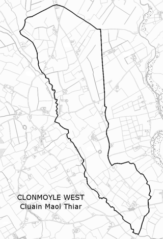
Clonmoyle West is a townland within both the civil parish and catholic parish of Aghabullogue, County Cork, Ireland. It is 774.06 acres in size, situate east of Aghabullogue village, and north-west of Coachford village.
Clontead More House is a country house in the townland of Clontead More, situated 2.3 km (1.4 mi) north-east of Coachford village. The house and demesne were dominant features in the rural landscape, throughout the eighteenth and nineteenth centuries. A number of such estate houses are situated along the valley of the River Lee and its tributaries.

Corraclassy is a townland in the civil parish of Templeport, County Cavan, Ireland. It lies in the Roman Catholic parish of Corlough and barony of Tullyhaw.
