
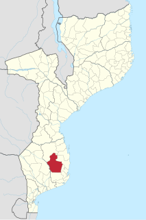
Gaza is a province of Mozambique. It has an area of 75,709 km2 and a population of 1,446,654.

Beira is the fourth largest city in Mozambique. It lies in the central region of the country in Sofala Province, where the Pungwe River meets the Indian Ocean. Beira had a population of 397,368 in 1997, which grew to 530,604 in 2019. It holds the regionally significant Port of Beira which acts as a gateway for both the central interior portion of the country as well as the land-locked nations of Zimbabwe, Zambia and Malawi.
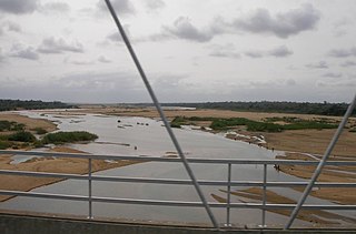
The Save River, or Sabi River is a 400 km (250 mi) river of southeastern Africa, flowing through Zimbabwe and Mozambique. The river has its source in Zimbabwe, some 80 km (50 mi) south of Harare, then flows south and then east, from the Zimbabwean highveld to its confluence with the Odzi River. It then turns south, drops over the Chivirira Falls, and flows down the western side of Zimbabwe's Eastern Highlands forming a dry river valley in the rain shadow of these mountains. It is joined by the Runde River or Lundi at the Mozambique border, forming a dramatic confluence at Mahenya. It then crosses Mozambique to flow into the Indian Ocean at about 21°S.

The Muar River is a river which flows through the states of Johor, Negeri Sembilan and Pahang in Malaysia. The river also flows through Muar town.

Tangkak is the principal town and capital of Tangkak District in Johor, Malaysia. The town is nicknamed "Fabric Town" or "Syurga Kain" in honour of its many textile shops. It is also well known as being a major entry point to Mount Ophir, the highest mountain in Johor.
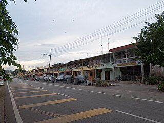
Panchor is a small town in Muar District, Johor, Malaysia, located next to Muar River. Panchor was formerly a bustling river port where agricultural and plantation produce, from the interior are loaded downriver on barges. However, as the road networks began to improve in the 1970s, which culminated with the construction of the North–South Expressway in the 1980s, Panchor declined in importance as barge river traffic decreased sharply. However, the opening of industrial parks in the vicinity brought a small revival in the town's population and its economy. In late 2006 and early 2007, Panchor was affected by the worst floods in Johor in over 100 years. that village affected is Kg Sg Ranggam, Sg Alai, Kg Terus, Kg Melayu, Semaseh and Kg Jawa. The Pekan Panchor is also famous for 'mengail udang' or fresh water prawning.
Bukit Kepong is a mukim in Muar District, Johor, Malaysia. It is located near the Muar River.
Kota Biawak Busuk, literally means "Fort of Smelly Monitor Lizard" in Malay is a historic site believed to be located near the site of another historic site the Kota Buruk, most possibly nearby or at today's Kampung Tanjung Selabu, Jorak, Sungai Terap, Bukit Pasir, Pagoh, Muar, Johor, Malaysia. The site of Kota Buruk is being preserved by the government and is open to the public for visit.

The Suncook River is a 35.7-mile-long (57.5 km) river located in central New Hampshire in the United States. It is a tributary of the Merrimack River, which flows to the Gulf of Maine.
Sungai Mati is a small town in Serom, Tangkak District, Johor, Malaysia.

Buzi River is a river in Mozambique. Buzi flows eastward through the Manica and Sofala provinces of Mozambique. It then empties to the Mozambique Channel west of Beira, forming an estuary.
Funhalouro District is a district of Inhambane Province in south-east Mozambique. Its principal town is Funhalouro. The district is located at the west of the province, and borders with Mabote District in the north, Inhassoro District in the northeast, Massinga and Morrumbene Districts in the east, Homoine District in the southeast, Inharrime District in the south, and with Chigubo District of Gaza Province in the west. The area of the district is 13,653 square kilometres (5,271 sq mi). It has a population of 37.925 as of 2007.

The Muar District is a district in Johor, Malaysia. Muar is located at the mouth of the Muar River, on the coast of the Straits of Malacca. The Muar District covers 1,354 km2, with a population of 233,779 (2010).

Muar (Jawi:موار) or Bandar Maharani is a historical town and the capital of Muar District, Johor, Malaysia. It is one of the most popular tourist attractions in Malaysia to be visited and explored for its food, coffee and historical prewar buildings. It was recently declared as the royal town of Johor by Sultan Ibrahim Sultan Iskandar and is the fourth largest city in Johor. It is the main and biggest town of the bigger entity region or area of the same name, Muar which is sub-divided into the Muar district and the new Tangkak district, which was upgraded into a full-fledged district from the Tangkak sub-district earlier. Muar district as the only district covering the whole area formerly borders Malacca in the northern part. Upon the upgrading of Tangkak district, the Muar district now covers only the area south of Sungai Muar, whilst the northern area beyond the river is in within Tangkak district. However, both divided administrative districts are still collectively and fondly called and referred to as the region or area of Muar as a whole by their residents and outsiders. Currently, the new township of Muar is located in the Bakri area.
Ostaszewo-Włuski is a village in the administrative district of Gmina Gzy, within Pułtusk County, Masovian Voivodeship, in east-central Poland.
The Luambala is a river of Mozambique. It flows through Niassa Province in a northeast-southwest direction. The Luambala valley was surveyed during the Portuguese Nyasaland. The river was reported to have steep sides and a rock bed. To the east of Cassembe, the Luambala connects with the Lugenda River at 13°26′12″S36°18′20″E, flowing in a north-south-southwest direction.
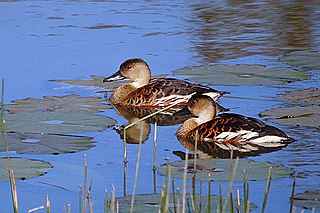
The Anson Bay, Daly and Reynolds River Floodplains comprise some 2,656 square kilometres (1,025 sq mi) of seasonally inundated floodplains around Anson Bay, and the lower reaches of the Daly, Reynolds and Docherty Rivers entering the bay, on the west coast of the Top End of the Northern Territory of Australia. Anson's Bay lies about 120 kilometres (75 mi) south-west of Darwin, on the eastern side of the Joseph Bonaparte Gulf, opening on to the Timor Sea. The site is important for large numbers, and a wide variety, of waterbirds.


