
Hydroelectricity is electricity produced from hydropower. In 2015, hydropower generated 16.6% of the world's total electricity and 70% of all renewable electricity, and was expected to increase about 3.1% each year for the next 25 years.

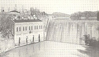
Norris Dam is a hydroelectric and flood control structure located on the Clinch River in Anderson County and Campbell County, Tennessee, United States. Its construction in the mid-1930s was the first major project for the Tennessee Valley Authority, which had been created in 1933 to bring economic development to the region and control the rampant flooding that had long plagued the Tennessee Valley. The dam was named in honor of Nebraska Senator George Norris (1861–1944), a longtime supporter of government-owned power in general, and supporter of TVA in particular. The project infrastructure was listed on the National Register of Historic Places in 2016.

Salal Dam, also known as Salal Hydroelectric Power Station, is a run-of-the-river power project on the Chenab River in the Reasi district of the Indian state of Jammu and Kashmir. The dam construction started after entering mutual agreement between India and Pakistan in 1978.

Douglas Dam is a hydroelectric dam on the French Broad River in Sevier County, Tennessee, in the southeastern United States. The dam is operated by the Tennessee Valley Authority (TVA), which built the dam in record time in the early 1940s to meet emergency energy demands at the height of World War II. Douglas Dam is a straight reinforced concrete gravity-type dam 1705 feet long and 202 feet high, impounding the 28,420-acre (11,500 ha) Douglas Lake. The dam was named for Douglas Bluff, a cliff overlooking the dam site prior to construction.

Lake Qaraoun is an artificial lake or reservoir located in the southern region of the Beqaa Valley, Lebanon. It was created near Qaraoun village in 1959 by building a 61-metre-high (200 ft) concrete-faced rockfill dam in the middle reaches of the Litani River. The reservoir has been used for hydropower generation, domestic water supply, and for irrigation of 27,500 hectares.

The Maithon Dam is located at Maithon, 48 km from Dhanbad, in the state of Jharkhand. It is 15,712 ft (4,789 m) long and 165 ft (50 m). high.

Santeetlah Dam is a hydroelectric development on the Cheoah River in Graham County, North Carolina. The dam together with a pipeline/tunnel facility, and a powerhouse form the Santeetlah Development. The Santeetlah powerhouse is located on the left bank of the Cheoah Reservoir portion of the Little Tennessee River five miles (8 km) upstream of the Cheoah Dam.
Nolichucky Dam is a dam on the Nolichucky River near Greeneville, Tennessee, maintained by the Tennessee Valley Authority (TVA). The dam is located just over 46 miles (74 km) upstream from the mouth of the Nolichucky, and impounds Davy Crockett Lake, which extends 6 miles (9.7 km) upstream from the dam.
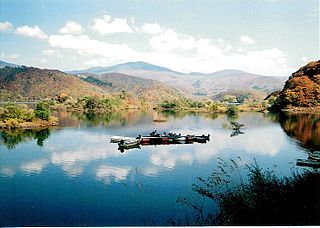
Akimoto Lake (秋元湖) is a lake that is technically classified as a reservoir. It straddles the border of the village of Kitashiobara and the town of Inawashiro, both in the Yama district of Fukushima Prefecture, Japan. Along with Hibara Lake and Onogawa Lake, it forms what is known as the "Inner Bandai Plateau Tri-Lake Formation".

Tims Ford Lake is a reservoir run by the Tennessee Valley Authority in southern middle Tennessee.
Watauga Dam is a hydroelectric and flood control dam on the Watauga River in Carter County, in the U.S. state of Tennessee. It is owned and operated by the Tennessee Valley Authority, which built the dam in the 1940s as part of efforts to control flooding in the Tennessee River watershed. At 318 feet (97 m), Watauga is the second-highest dam in the TVA river and reservoir system, and at the time of its completion was one of the highest earth-and-rock dams in the United States. The dam impounds the TVA Watauga Reservoir of 6,430 acres (2,600 ha), and its tailwaters feed into Wilbur Lake. The Appalachian Trail crosses the top of Watauga Dam.

Cherokee Dam is a hydroelectric dam located on the Holston River in Grainger County and Jefferson County, Tennessee, in the southeastern United States. The dam is operated and maintained by the Tennessee Valley Authority, which built the dam in the early 1940s to help meet urgent demands for energy at the outbreak of World War II. Cherokee Dam is 175 feet (53 m) high and impounds the 28,780-acre (11,650 ha) Cherokee Lake. It has a generating capacity of 135,200 kilowatts. The dam was named for the Cherokee, a Native American tribe that controlled much of East Tennessee when the first European settlers arrived in the mid-18th century.

Chatuge Dam is a flood control and hydroelectric dam on the Hiwassee River in Clay County, in the U.S. state of North Carolina. The dam is the uppermost of three dams on the river owned and operated by the Tennessee Valley Authority, which built the dam in the early 1940s for flood storage and to provide flow regulation at Hiwassee Dam further downstream. The dam impounds the 7,000-acre (2,800 ha) Chatuge Lake, which straddles the North Carolina-Georgia state line. While originally built solely for flood storage, a generator installed at Chatuge in the 1950s gives the dam a small hydroelectric output. The dam and associated infrastructure was listed on the National Register of Historic Places in 2017.

Wilbur Dam is a hydroelectric dam on the Watauga River in Carter County, in the U.S. state of Tennessee. It is one of two dams on the river owned and operated by the Tennessee Valley Authority. The dam impounds Wilbur Lake, which extends for about 3 miles (4.8 km) up the Watauga to the base of Watauga Dam. Completed by 1912 the Ocoee Dam No. 1 is the only Hydroelectric dam that is older, Wilbur Dam was one of the first major hydroelectric projects in Tennessee, and remains one of the oldest dams in the TVA system.

Fort Patrick Henry Dam is a hydroelectric dam on the South Fork Holston River within the city of Kingsport, in Sullivan County in the U.S. state of Tennessee. It is the lowermost of three dams on the South Fork Holston owned and operated by the Tennessee Valley Authority, which built the dam in the early 1950s to take advantage of the hydroelectric potential created by the regulation of river flow with the completion of Watauga Dam, South Holston Dam, and Boone Dam further upstream in preceding years. The dam impounds the 872-acre (353 ha) Fort Patrick Henry Lake. While originally built for hydroelectric generation, the dam now plays an important role in the regulation of water flow and water temperature for the John Sevier Fossil Plant and other industrial plants downstream. The dam and associated infrastructure were listed on the National Register of Historic Places in 2017.
The Imha Dam is an embankment dam on the Banbyeoncheon River, a tributary of the Nakdong River, 14 km (9 mi) east of Andong in Gyeongsangbuk-do province, South Korea. The purpose of the dam is flood control, water supply and hydroelectric power generation. Construction on the dam began in 1987 and it was complete in 1991. The 73 m (240 ft) tall rock-fill, central earth-core dam creates a reservoir with a capacity of 595,000,000 m3 (482,374 acre⋅ft) and supplies a 50 MW power station with water. It supplies water for both municipal and industrial uses to Gumi, Dagu, Masan, Changwon, Jinhae, Woolsan, and Busan.
Norris Lake is a reservoir that is located in Anderson, Campbell, Claiborne, Grainger, and Union Counties in Tennessee. The lake was created by the Norris Dam at the Cove Creek Site on the Clinch River in 1936 by the Tennessee Valley Authority (TVA) for flood control, water storage, and hydroelectric power. Norris Dam and its reservoir were the first major project taken on by the TVA. The lake, the dam, and the town of Norris, Tennessee are named for George W Norris, who was a U.S. Senator from Nebraska and who wrote the legislation that created the TVA.


