
Yeongju is a city in the far north region of North Gyeongsang province in South Korea, covering 668.84 km2 with a population of 113,930 people according to the 2008 census. The city borders Bonghwa county to the east, Danyang county of North Chungcheong province to the west, Andong city and Yecheon county to the south, and Yeongwol county of Gangwon province to the north.

Hwasun County is a county in South Jeolla Province, South Korea.
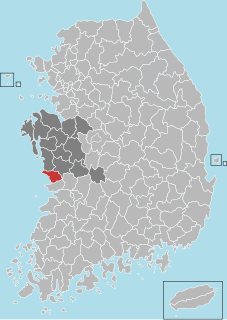
Seocheon County (Seocheon-gun) is a county in Chungcheongnam-do, South Korea. It is famous for its seafood and location near the mouth of the Geum River.

Ulleung County (Ulleung-gun) is a county in North Gyeongsang Province, South Korea. It consists mainly of the island of Ulleungdo, but is held to cover a total of 44 islands, including the Liancourt Rocks, which is contested by Japan and North Korea. All of these islands lie within the Sea of Japan.
The sites of fossilized dinosaurs across the southern South Korean coast is a tentative UNESCO World Heritage site registered by the South Korean government since 2002. Although the evidence is rare, fossils reveal that there were dinosaurs in South Korea. The ancient remains of dinosaurs are located within a beautiful display of nature that includes petrified wood, the tracks of extinct dinosaurs and other animals, the exposure of geographic rock layers, and particular river drifts. This dinosaur park is well protected by the local governments and by the Marine National Park and is an invaluable resource for understanding the ecosystem and nesting behaviors of dinosaurs of the Mesozoic.

Sannae-myeon is a myeon or a township in the subdivision of Gyeongju City, North Gyeongsang province, South Korea. Its 142.64 square kilometers are home to about 3,624 people. This population is served by one elementary school, two branch schools and a kindergarten affiliated with the elementary school, and one joint middle-high school.

Seo-myeon is a myeon or a township in the subdivision of the Gyeongju City, North Gyeongsang province, South Korea. It is bordered by its neighborhoods including Hyeongok-myeon and Geoncheon-eup on the east, Sannae-myeon on the south and Yeongcheon City on the west and north. Its 52.12 square kilometers are home to about 4,166 people. This population is served by one elementary school and one joint middle school.

Hyeongok-myeon is a myeon or a township in the administrative subdivisions of the Gyeongju City, North Gyeongsang province, South Korea. It is bordered by Hyeongsan River, Cheonbuk-myeon and Yonghwang-dong on the east, Bodeok-dong on the south and Geoncheon-eup on the southwest, Seo-myeon on the west and Angang-eup on the north. Its 55.74 square kilometers are home to about 13,658 people. This population is served by three elementary schools, one middle school and one high school.

Cheonbuk-myeon is a myeon or a township in the administrative subdivisions of the Gyeongju City, North Gyeongsang province, South Korea. It is bordered by Pohang city on the east, Bodeok-dong on the south, Angang-eup and Hyeongok-myeon to the boundary Hyeongsan River on the west and Gangdong-myeon on the north. Its 58.15 square kilometers are home to about 6,140 people. This population is served by two elementary schools, one high school.

Yangbuk-myeon is a myeon or a township in the administrative subdivisions of the Gyeongju City, North Gyeongsang province, South Korea. It is bordered by Gampo-eup and Sea of Japan on the east, Yangnam-myeon on the south, Bulguk-dong, Bodeok-dong and Oedong-eup on the west and Ocheon-eup and Janggi-myeon of the Pohang city on the north. Its 120.06 square kilometers are home to about 4,558 people. This population is served by one joint elementary-middle school.

Naenam-myeon is a myeon or a township in the administrative subdivisions of the Gyeongju City, North Gyeongsang province, South Korea. It is bordered by Geumo Mountains on the east, Jusa Mountains on the south. Its 122.05 square kilometers are home to about 6,142 people. This population is served by one elementary school and one high school.
Socheon-myeon is a myeon or a township in Bonghwa county of North Gyeongsang province in South Korea. The total area of Socheon-myeon is 264.17 square kilometers, and, as of 2006, the population was 2,519 people. Socheon-myeon is further divided into seven "ri", or small villages.
Jaesan-myeon is a myeon or a township in Bonghwa county of North Gyeongsang province in South Korea. The total area of Jaesan-myeon is 126.01 square kilometers, and, as of 2006, the population was 1,692 people. Jaesan-myeon is further divided into five "ri", or small villages.

Bongdam is a town in the city of Hwaseong in South Korea. Covering over 4000 hectares, the town is the focus of a planned community, primarily as a commuter town for the bordering city of Suwon.

"Hwanghae Province" or "Hwanghae-do" is, according to South Korean law, a province of the Republic of Korea, as the South Korean government formally claims to be the legitimate government of whole of Korea. The area constituting the province is under the de facto jurisdiction of North Korea.

Nam-gu is a non-autonomous district in the City of Pohang in North Gyeongsang Province, South Korea. Its name literally means "South District" as it is one of two districts in the city, the other being Buk-gu or "North District".

Sora-myeon, also called as Sora Township, or shortly Sora, is a myeon (township) in Yeosu city of South Jeolla Province, South Korea. The myeon is located in center-western part of the city. The total area of the myeon is 60.5 square kilometres, and, as of the last day of 2010, the population was 12256 people, 5195 houses. The township hall is located in Deogyang-ri, and address of the township hall is 389, Deogyang-ro, Sora-myeon. Hwayang-myeon is souther and Yulchon-myeon, is norther, Samil-dong and the Gwangyang Bay is north-Easter, Jusam-dong and Yeocheon-dong is Easter, Ssangbong-dong is south-Easter, and the Yeoja Bay is wester.
Samsan-myeon, also called Samsan Township, or Samsan for short, is a myeon (township) in Yeosu, a city in South Jeolla Province, South Korea. The township is located in the south-western part of the city with a total area of 27.48 square kilometres (10.61 sq mi). The population was recorded to be 2643 people, 1438 males and 1205 females, and the number of houses totaled 1261. The myeon office is located in 28-10, Geomun-gil in Geomun-ri. There are Jeju Province in the south-west of the myeon; mainland of Yeosu in the north-east; Goheung County in the north; and Wando County in the north-east. There is Geomundo/Baekdo zone of Dadohaehaesang National Park in Geomundo and Baekdo. The name of the myeon, Samsan, which means three mountains, is from three main islands in Geomumdo which looked like three mountains: Seodo, Dongdo, and Godo.


