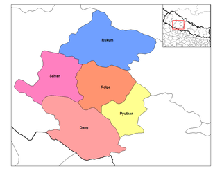
Rapti Zone was one of the fourteen zones, located in the Mid-Western Development Region of Nepal. It was named after the West Rapti River which drains Rolpa, Pyuthan and part of Dang districts. The remainder of Dang and part of Salyan district are drained by the Babai. The remainder of Salyan and all of Rukum districts are drained by the Bheri.

The Magar, also spelled as Mangar, and Mongar, are the third largest ethnolinguistic groups of Nepal representing 7.1% of Nepal's total population according to the Nepal census of 2011.

Rukum District was a "hill" and "mountain" district some 280 km (170 mi) west of Kathmandu partially belonging to Lumbini Province and partially to Karnali Pradesh before split into two districts Western Rukum and Eastern Rukum after the state's reconstruction of administrative divisions in 2017. Rukum covers an area of 2,877 km2 (1,111 sq mi) with population of 207,290 in 2011 Nepal census. Musikot was the district's administrative center.

Salyan or Salyan Khalanga is the headquarters of Salyan District in the mid-west 'hills' of Nepal. It is located at 28°22'31N 82°9'42E at 1530 metres elevation (5020 feet).
Burtibang is a village development committee in Baglung District in the Dhaulagiri Zone of central Nepal. Burtibang is the second-largest commercial city in the district after Baglung.
Arlangkot Gulmi is a small village, ward no 9 of Musikot municipality in Gulmi District in the Lumbini Zone of westernNepal. It includes three small towns Dadalka, arlangkot and Dashikot where upper part is more like mountains and people grow corn, wheat, millet and other lentils as their primary agricultural products. Lower part of arlangkot includes lamakhet, pandathok and kabrachaau which is plain area of arlangkot spread on side of Daram khola. Here people grow rice as their primary grains because of irrigation facility in the lower plain areas. it is boarded by baglung district on south and west whereas with Wami and Daha on east and North respectively. At the time of the 1991 Nepal census it had a population of 2498 persons living in 424 individual households.
Chaurjahari is a Municipality in Western Rukum District in Karnali province of Nepal that was established in 2015 through the merging the two former Village development committees Bijayaswori and Kotjahari. It lies on the bank of Sani Bheri River. At the time of the 2011 Nepal census it had a population of 27,438 people living in 5,422 individual households.

Musikot is a municipality and the district headquarter of Western Rukum District in Karnali province of Nepal that was established as Musikot Khalanga on 2 December 2014 by merging the two former Village development committees Musikot and Khalanga. It lies on the bank of Sani Bheri River. It borders with Eastern Rukum in the east, Sanibheri rural municipality in the west, Banfikot rural municipality in the north and Tribeni rural municipality and Rolpa district in the south. Musikot was formerly called Musikot Khalanga and served as the district headquarter of Rukum District.
Jhumlawang village is a home of about 850 inhabitants from 6 major ethnic groups of Nepal- Magar, Newar, Gurung, Thakuri, Chhetri, and Dalits. The village is located in Morawang VDC Ward No 8 &9, East Rukum District of Mid-Western Nepal. The elevation of Jhumlawang village is about 2328 m (7633 ft.) but varies from 1600m to 3100m.
Lumbini Province is one of the seven provinces established by the constitution of Nepal. The province is Nepal's fourth most populous province and third largest province by area. Lumbini is bordered by Gandaki Province and Karnali Province to the north, Sudurpashchim Province to the west, Uttar Pradesh and Bihar of India to the south. Lumbini is one of the two Nepalese provinces to have an international border only with India. Lumbini's capital, Deukhuri, is near the geographic centre of the province; it is a small town which is currently being developed to meet the prerequisite of provincial capital. The major cities in this province are Butwal and Siddharthanagar in Rupandehi District, Nepalgunj in Banke District, Tansen in Palpa District, and Ghorahi and Tulsipur in Dang District. The province is home to the World Heritage Site of Lumbini, where according to the Buddhist tradition, the founder of Buddhism, Gautama Buddha was born.

Western Rukum a part of Karnali province, is one of the seventy-seven districts of Nepal. Musikot is the headquarter of the district.

Salle Airport, also known as Musikot Airport, is a domestic airport located in Musikot Khalanga serving Western Rukum District, a district in Karnali Pradesh in Nepal. It is the main tourist gateway to Mount Sisne.

Rapti Highway is a highway in central Nepal that crosses the districts of Dang, Salyan and West Rukum in a south to north direction. The 176 km highway branches off Mahendra Highway in Satbariya towards Tulsipur in the North, where it intersects with Feeder Road 15 just north of Dang Airport, a road that connects the highway to the district headquarter of Dang, Ghorahi. Rapti Highway then follows Sharada River and passes the municipalities Sharada and Bagchaur. From there, the highway runs towards Musikot Khalanga, the district headquarter of West Rukum District, where it terminates.
Musikot is an urban municipality located in Gulmi District of Lumbini Province of Nepal.
Gulmi is a district in Nepal.

Gulmi 2 one of two parliamentary constituencies of Gulmi District in Nepal. This constituency came into existence on the Constituency Delimitation Commission (CDC) report submitted on 31 August 2017.
This page is based on this
Wikipedia article Text is available under the
CC BY-SA 4.0 license; additional terms may apply.
Images, videos and audio are available under their respective licenses.