
The Santa Cruz Mountains, part of the Pacific Coast Ranges, are a mountain range in central and northern California, United States. They form a ridge down the San Francisco Peninsula, south of San Francisco. They separate the Pacific Ocean from the San Francisco Bay and the Santa Clara Valley, and continue south to the Central Coast, bordering Monterey Bay and ending at the Salinas Valley. The range passes through the counties of San Mateo, Santa Clara, Santa Cruz, San Benito and Monterey, with the Pajaro River forming the southern boundary.
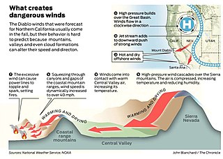
Diablo wind is a name that has been occasionally used for the hot, dry wind from the northeast that typically occurs in the San Francisco Bay Area of Northern California, during the spring and fall.

Mount Diablo is a mountain of the Diablo Range, in Contra Costa County of the eastern San Francisco Bay Area in Northern California. It is south of Clayton and northeast of Danville. It is an isolated upthrust peak of 3,849 feet, visible from most of the San Francisco Bay Area. Mount Diablo appears from many angles to be a double pyramid and has many subsidiary peaks. The largest and closest is North Peak, the other half of the double pyramid, which is nearly as high in elevation at 3,557 feet (1,084 m), and is about one mile northeast of the main summit.
The Sunol Regional Wilderness is a regional park in Alameda County, the eastern San Francisco Bay Area, Northern California. It is located near the town of Sunol, south of Pleasanton and east of Fremont.
Twin Peaks is an American television series, running from 1990 to 1991; and in 2017.

Henry W. Coe State Park is a state park of California, United States, preserving a vast tract of the Diablo Range. The park is located closest to the city of Morgan Hill, and is located in both Santa Clara and Stanislaus counties. The park contains over 87,000 acres (35,000 ha), making it the largest state park in northern California, and the second-largest in the state. Managed within its boundaries is a designated wilderness area of about 22,000 acres (8,900 ha). This is officially known as the Henry W. Coe State Wilderness, but locally as the Orestimba Wilderness. The 89,164-acre (36,083 ha) park was established in 1959.

Junipero Serra Peak is the highest mountain in the Santa Lucia range of central California. It is also the highest peak in Monterey County, and is located within the boundaries of Los Padres National Forest. It is named after Saint Junípero Serra, the Spanish Franciscan priest who founded the California Missions in the 18th century. There is a fire lookout, with a tower and building, near the peak that was constructed around 1935. An unauthorized skiing operation on the summit was reported sometime before 1970. Good astronomical observing conditions were an early attraction to the peak. Astronomers scratched a trail to the summit in January 1880 to observe a total eclipse of the sun. Observations from the peak were also made on the transit of Venus in 1882.

The Diablo Range is a mountain range in the California Coast Ranges subdivision of the Pacific Coast Ranges in northern California, United States. It stretches from the eastern San Francisco Bay area at its northern end to the Salinas Valley area at its southern end.
Windy Hill Open Space Preserve is a regional park located in San Mateo County, California and operated by the Midpeninsula Regional Open Space District (MROSD). It is readily identifiable from the flatlands of the South Bay, as it is the only "naked" part of the peninsula range.
Mount Diablo (disambiguation) may refer to:

The Coast Ranges of California span 400 miles (644 km) from Del Norte or Humboldt County, California, south to Santa Barbara County. The other three coastal California mountain ranges are the Transverse Ranges, Peninsular Ranges and the Klamath Mountains.
The Gabilan Range or Gabilán Range are a mountain range in the inner California Coast Ranges System, located in Monterey County and San Benito County of central California. Pinnacles National Park is located in the southern section of the range.
Black Mountain, is a ridge in the Diablo Range of southwestern Fresno County, California, south of Reef Ridge. Its east end begins about 1.25 miles west of Zwang Peak, and runs at elevations over 4000 feet, with the mid ridge rising to 4345 feet, westerly about 3.25 miles to Castle Mountain at an elevation of 4343 feet. It then turns west northwest 2 miles at elevations above 3790 feet with several peaks over 3800 feet and one over 3900 feet along the length of it. There it is linked to the next east west mountain ridge extending east from Mustang Peak. The high point of the ridge is 7.7 miles (12.4 km) north northeast of Parkfield, California.
La Vereda del Monte was a backcountry route through remote regions of the Diablo Range, one of the California Coast Ranges. La Vereda del Monte was the upper part of La Vereda Caballo,, used by mesteñeros from the early 1840s to drive Alta California horses to Sonora for sale.
Mustang Peak is a mountain summit along the divide of the Diablo Range in Stanislaus County, California. It rises to an elevation of 2,251 / 686 meters.
Mustang Flat is a flat in the Diablo Range in Stanislaus County, California. It lies at an elevation of 1,329 feet / 405 meters south of the South Fork Orestimba Creek, north of Mustang Peak.
County Line Road is an unimproved road between the San Antonio Valley and Fifield Ranch that closely follows the east-west divide of the Diablo Range and the County boundary of Santa Clara County, and Stanislaus County, California. This road followed the route called La Vereda del Monte, used by Californio mesteñeros and the gang of Joaquin Murrieta and other bandits and horse-thieves, and sites of three of their camps along the route are found along it. Two sites are now state park campgrounds, the last is at ranch dating back to the 1860s.
Mustang Peak is a summit in the Diablo Range on the northwest - southeast trending range of mountains marking the boundary of Monterey County and Fresno County, California. This summit rises to an elevation of 3,596 feet / 1,096 meters. It overlooks the Kreyenhagen Hills and Kettleman Plain beyond it to the east, and the Jacalitos Hills and Pleasant Valley beyond it to the north. To the south is Joaquin Canyon, tributary to Cholame Creek and to the west is Mine Mountain and Cholame Creek beyond it, below its summit.