
Georg Leo Graf von Caprivi de Caprara de Montecuccoli was a German general and statesman. He served as the chancellor of the German Empire from March 1890 to October 1894.

The Zambezi Region is one of Namibia's fourteen regions, situated in the north-eastern part of the country along the Zambezi River. The region's capital is Katima Mulilo. The Katima Mulilo Airport is 18 kilometres south-west of the town, while the village of Bukalo is located 43 kilometres south-east of Katima Mulilo. Known as the Caprivi Region until 2013, it has eight electoral constituencies and a population of 142,373 according to the 2023 census.

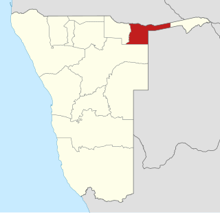
The Caprivi Strip, also known simply as Caprivi, is a geographic salient protruding from the northeastern corner of Namibia. It is bordered by Botswana to the south and Angola and Zambia to the north. Namibia, Botswana and Zambia meet at a single point at the eastern tip of the Strip, which also comes within 150 m (490 ft) of Zimbabwe, thus nearly forming a quadripoint. Botswana and Zambia share a 150-metre (490 ft) border at the crossing of Kazungula.

Namibia uses regions as its first-level subnational administrative divisions. Since 2013, it has 14 regions which in turn are subdivided into 121 constituencies.

KhweKWAY is a dialect continuum of the Khoe branch of the Khoe-Kwadi family of Namibia, Angola, Botswana, South Africa, and parts of Zambia, with some 8,000 speakers.

Katima Mulilo or simply Katima is the capital of the Zambezi Region in Namibia. It had 46,401 inhabitants in 2023, and comprises two electoral constituencies, Katima Mulilo Rural and Katima Mulilo Urban. It is located on the B8 national road on the banks of the Zambezi River in the Caprivi Strip in lush riverine vegetation with tropical birds and monkeys. The town receives annual average rainfall of 654 millimetres (25.7 in).

The Walvis Bay-Ndola-Lubumbashi Development Road, formerly known as the Trans-Caprivi Corridor and until 2004 the Trans-Caprivi Highway, begins in Walvis Bay. It runs through Rundu in northeastern Namibia and along the Caprivi Strip to Katima Mulilo on the Zambezi River, which forms the border between Namibia and Zambia. The Katima Mulilo Bridge spans the river to the Zambian town of Sesheke. From there, the road continues as the M10 Road to Livingstone, where it connects to the main north–south highway to Lusaka and extends to the Copperbelt.

Khaudum National Park is an isolated nature reserve situated in the Kalahari Desert to the west of the Caprivi Strip in the northeast of Namibia. It is a very remote and inaccessible reserve, but is home to some magnificent animals, such as the lion and hyena. The park has a campsite for visitors.

Mittelafrika is the name created for a geostrategic region in central and east Africa. Much like Mitteleuropa, it articulated Germany's foreign policy aim, prior to the First World War, of bringing the region under German domination. The difference being that Mittelafrika would presumably be an agglomeration of German colonies in Africa, while Mitteleuropa was conceptualised as a geostrategic buffer zone between Germany and Imperial Russia to be filled with puppet states.

The Caprivi conflict was an armed conflict between the Namibian government and the Caprivi Liberation Army, a rebel group that waged a brief insurrection in 1999 for the secession of the Caprivi Strip.

Albert Mishake Muyongo is a Namibian politician and former Member of Parliament who is currently living in exile in Denmark.

Caprivi Liberation Army (CLA) is a Namibian rebel and separatist group which was established in 1994 to separate the Caprivi Strip, a region mainly inhabited by the Lozi people. It operates only in the Caprivi strip.

ISO 3166-2:NA is the entry for Namibia in ISO 3166-2, part of the ISO 3166 standard published by the International Organization for Standardization (ISO), which defines codes for the names of the principal subdivisions of all countries coded in ISO 3166-1.
John Mabuku was the governor of Caprivi Region in Namibia and secessionist supporter of an independent Caprivi Strip. Mabuku, a former Democratic Turnhalle Alliance National Council member, fled to exile in Botswana with former DTA leader Mishake Muyongo following a failed separatist revolt in 1998 in the Caprivi Strip against the Namibian government.
Victor Simunja is a Namibian politician. A member of the South West Africa People's Organization (SWAPO), Simunja was appointed to the National Assembly of Namibia in 2000 and served as Deputy Minister of Defense from 2000 to 2009. Simunja rose to the rank of lieutenant colonel in the Namibian Defence Force prior to entering political office. He is a member of the Mafwe ethnic group, indigenous to the Caprivi Strip.
The Caprivi treason trial is a trial in which the Government of Namibia indicted 132 people for allegedly participating in the Caprivi conflict on the side of the Caprivi Liberation Army during a period between 1992 and 2002. They were charged with high treason, murder, sedition, and many other offences, altogether 278 counts of criminal conduct.

Bwabwata National Park is a protected area in northeastern Namibia that was established in 2007 and covers 6,274 km2 (2,422 sq mi). It was created by merging Namibia's Caprivi Game Park and Mahango Game Park. It is situated in the Zambezi and Kavango East regions, extending along the Caprivi Strip. It is bounded by the Okavango River to the west and the Kwando River to the east. Angola lies to the north and Botswana to the south.
Kavango East is one of the fourteen regions of Namibia. Its capital is Rundu, its governor is Bonifatius Wakudumo. The region was created in 2013 when the Kavango Region was split into Kavango East and Kavango West. The only self-governing settlements in Kavango East are the capital Rundu and the village of Divundu.

33 Battalion or the Eastern Caprivi Battalion, was a light infantry battalion that was part of the SWATF.
