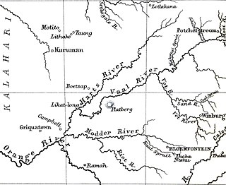
The Orange River is the longest river in South Africa and the Orange River Basin extends extensively into Namibia and Botswana to the north. It rises in the Drakensberg mountains in Lesotho, flowing westwards through South Africa to the Atlantic Ocean. The river forms part of the international borders between South Africa and Namibia and between South Africa and Lesotho, as well as several provincial borders within South Africa. Except for Upington, it does not pass through any major cities. The Orange River plays an important role in the South African economy by providing water for irrigation and hydroelectric power. The river was named the Orange River in honour of the Dutch ruling family, the House of Orange, by the Dutch explorer Robert Jacob Gordon. Other names include Gariep River, Groote River or Senqu River.

The Olifants River, Lepelle or Obalule is a river in South Africa and Mozambique, a tributary of the Limpopo River. It falls into the Drainage Area B of the Drainage basins of South Africa. The historical area of the Pedi people, Sekhukhuneland, is located between the Olifants River and one of its largest tributaries, the Steelpoort River.

Gariep Dam located in South Africa, near the town of Norvalspont, bordering the Free State and Eastern Cape provinces. Its primary purpose is for irrigation, domestic and industrial use as well as for power generation.
Kromme Dam, is a multi-arch type dam located at the Kromme River, near Kareedouw, Eastern Cape, in South Africa. It was established in 1943 and its main purpose is for municipal and industrial usage.

Inanda Dam is an earth-fill type dam located on the Mgeni River, near Hillcrest, KwaZulu-Natal, South Africa. It was established in 1989 and its primary purpose is to serve for domestic and industrial use.
Luphephe Dam is an arch type dam located on the Luphephe River, a tributary of the Nwanedi River, part of the Limpopo River basin. It is located 48 km to the SW of Musina, Limpopo, South Africa. It was established in 1964 and it serves mainly for irrigation purposes. The hazard potential of the dam has been ranked high (3).
Mokolo Dam is a rock-fill type dam located on the Mokolo River, near Lephalale, Limpopo, South Africa. It was established in 1980. The Malmanies River and the Bulspruit River, two tributaries of the Mokolo, also enter the dam from its left side. The dam supplies water to Lephalale town. The dam mainly serves for municipal and industrial purposes and its hazard potentials has been ranked high (3).
Nwanedi Dam is an arch type dam located on the Nwanedi River, part of the Limpopo River basin. It is located in Limpopo Province, South Africa. It was established in 1964 and serves mainly for irrigation purposes. The hazard potential of the dam has been ranked high (3).
Ncora Dam is a gravity type dam located on the Tsomo River, near Tsomo, Eastern Cape, South Africa. It was established in 1972 and serves mainly for irrigation purposes. The hazard potential of the dam has been ranked high (3).

The Sand River is a river in the Free State, South Africa. It is located close to Welkom and Virginia in the gold mining center of the Free State. Its source is located close to Tweefontein NW of Ficksburg not far from the South Africa/Lesotho border, at 28°40′49″S27°41′23″E. This river is famous because of the historical Sand River Convention, an important event in South African history.

The Levubu River or Levuvhu is located in the northern Limpopo province of South Africa. Some of its tributaries, such as the Mutshindudi River and Mutale River rise in the Soutpansberg Mountains.
Fika-Patso Dam is a combined earth-fill/rock-fill type dam located on the Namahadi River, the uppermost section of the Elands River, a tributary of the Wilge River.
Hazelmere Dam is a combined concrete gravity type dam located on the Mdloti River, Kwazulu Natal, South Africa. It was established in 1977 and its primary purpose is to serve for irrigation and domestic use. The hazard potential of the dam assembly has been ranked high (3).
Injaka Dam, also spelled Inyaka Dam is an earth-fill type dam located on the Ngwaritsane River, near Bushbuckridge, Mpumalanga, South Africa. It was established in 2001 and its primary purpose is to store water for irrigation use. The hazard potential of the dam has been ranked as high (3).

The Crocodile River is a river in South Africa. After its confluence with the Marico River, both rivers form the Limpopo River.

Middelburg Dam is a dam located on the Klein Olifants River, part of the Olifants River basin. It is located near Middelburg, Mpumalanga, South Africa. Construction was completed in 1978. The primary purpose of the dam is to serve for water supply and its hazard potential has been ranked high (3).
Mthatha Dam is an earth-fill type dam located on the Mthatha River, near Mthatha, Eastern Cape, South Africa. It was established in 1977 and serves mainly for municipal and industrial purposes. Its hazard potential has been ranked high (3).
Sandile Dam is a zoned embankment dam located on the Keiskamma River Ezingcuka near Keiskammahoek, Eastern Cape, South Africa. It was established in 1983 and serves mainly for irrigation purposes. The hazard potential of the dam has been ranked high (3).


