The Krishna River is a river in the Deccan plateau and is the third-longest river in India, after the Ganges and Godavari. It is also the fourth-largest in terms of water inflows and river basin area in India, after the Ganges, Indus and Godavari. The river, also called Krishnaveni, is 1,400 kilometres (870 mi) long and its length in Maharashtra is 282 kilometres. It is a major source of irrigation in the Indian states of Maharashtra, Karnataka, Telangana and Andhra Pradesh.

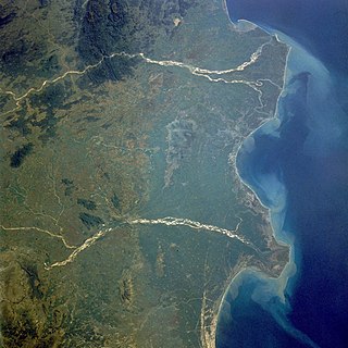
The Godavari is India's second longest river after the Ganga river and drains the third largest basin in India, covering about 10% of India's total geographical area. Its source is in Trimbakeshwar, Nashik, Maharashtra. It flows east for 1,465 kilometres (910 mi), draining the states of Maharashtra (48.6%), Telangana (18.8%), Andhra Pradesh (4.5%), Chhattisgarh (10.9%) and Odisha (5.7%). The river ultimately empties into the Bay of Bengal through an extensive network of distributaries. Measuring up to 312,812 km2 (120,777 sq mi), it forms one of the largest river basins in the Indian subcontinent, with only the Ganga and Indus rivers having a larger drainage basin. In terms of length, catchment area and discharge, the Godavari is the largest in peninsular India, and had been dubbed as the Dakshina Ganga.

East Godavari is a district in the Coastal Andhra region of Andhra Pradesh, India. Its district headquarters is at Rajamahendravaram.

The West Godavari district is a coastal district in the Indian state of Andhra Pradesh with an administrative headquarters in Bhimavaram. As of the 2011 Census of India, the district has an area of 2,178 km2 (841 sq mi) and a population of 1,779,935. It is bounded by the Krishna district and Bay of Bengal to the south, East Godavari district to the east, and Eluru district, Kolleru Lake and Upputeru Drain to the northwest.
Kakinada is the sixth largest city of the Indian state of Andhra Pradesh and serves as the district headquarters of the Kakinada District. It lies on the coast of the Bay of Bengal. J.N.T.U. College of Engineering Kakinada, established in 1946, is the oldest and popular Government college in the state of Andhra Pradesh. The First Polytechnic college of Andhra Pradesh, Andhra Polytechnic was established here in 1946. It was also the origin point of Buckingham Canal where goods used to be transported by boats during the British rule. It was once home for Asia's largest sea port. Many people from the city migrated from this sea port to countries like Burma, Mauritius, Fiji and various southeast Asian countries to work there as workers where they were called as Coringas.

Antarvedi is a village in the Sakhinetipalle mandal, located in the Dr. B. R. Ambedkar Konaseema district of the Andhra Pradesh state in India. The village is situated at the place where the Bay of Bengal and Vashista Godavari, a distributary of the Godavari River, meet.

Palakollu is a city and the administrative headquarters of Palakollu Mandal in Narasapuram revenue division in West Godavari district of the Indian state of Andhra Pradesh. Palakollu is situated in Coastal Andhra region of the state. It occupies 4.685 square kilometres (1.809 sq mi). As of 2011 census, it had a population of about 61,284 and a Metro population of about 81,199. Palakollu Municipality merged five Grama panchayats of Seven village's on 7 January 2020. The Seven Villages' had a population of 42,932 as of 2011 Census. It around occupies 20.08 square kilometres (7.75 sq mi) and after merged palakollu municipality, It around occupies 24.68 square kilometres (9.53 sq mi) with 35 election wards it is total population of 1,04,216 and making it the third most populous urban area in West Godavari District in Andhra Pradesh. It is a part of Eluru Urban Development Authority.

Nagarjuna Sagar Dam is a masonry dam across the Krishna River at Nagarjuna Sagar which straddles the border between Palnadu district in Andhra Pradesh and Nalgonda district in Telangana. The dam provides irrigation water to the districts of Palnadu, Guntur, Nalgonda, Prakasam, Khammam, Krishna, and parts of West Godavari. It is also a source of electricity generation for the national grid.
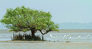
Coringa Wildlife Sanctuary is an estuary situated near Kakinada in Andhra Pradesh, India. It is the third largest stretch of mangrove forests in India with 24 mangrove tree species and more than 120 bird species. It is home to the critically endangered white-backed vulture and the long billed vulture. Mangroves are a group of trees and shrubs that live in the coastal intertidal zone, with a dense tangle of prop roots that make the trees appear to be standing on stilts above the water. This tangle of roots allows the trees to handle the daily rise and fall of tides; hence, the mangrove forest gets flooded at least twice per day. The roots also slow the movement of tidal waters, causing sediments to settle out of the water and build up the muddy bottom.
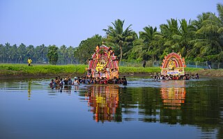
Konaseema is a group of islands between the tributaries of the Godavari River and Bay of Bengal located in Dr. B. R. Ambedkar Konaseema district of Andhra Pradesh in southern India. It is nicknamed "God's own creation" due to similarities with the Kerala backwaters.

Mukteswaram is a village located in Ainavilli Mandal, Konaseema Delta, Amalapuram revenue division in Konaseema district of Andhra Pradesh, India. It is situated near the River Gautami-Godavari, a tributary to the Godavari. Mukteswaram is one of the three important Ferry points for Kotipalli-Mukteswaram and the other two being; Bodasakurru-Pasarlapudi and Sakhinetipalli-Narasapuram in the Konaseema region. Mukteswaram is 60 km from Kakinada.
Narasapuram is a town in West Godavari district of the Indian state of Andhra Pradesh. It is a municipality and mandal headquarters of Narasapuram mandal in Narasapuram revenue division. The city is situated on the banks of the Vasista Godavari River. The lace industry is prevalent in the city and its surroundings.
The Godavari Bridge or Kovvur–Rajahmundry Bridge is a truss bridge spanning the Godavari River in Rajahmundry, India. It is India's fourth longest road-cum-rail bridge crossing a water body, the first one being the Bogibeel Bridge, also a rail-cum-road bridge over the Brahmaputra River in the Dibrugarh district of Assam state in north-east India, and second is Digha–Sonpur Bridge over Ganges in Bihar.

Achanta is a village in Achanta mandal of West Godavari district in the Indian state of Andhra Pradesh.

Andhra Pradesh lies between 12°41' and 19.07°N latitude and 77° and 84°40'E longitude, and is bordered by Telangana to the north and west, Chhattisgarh to the north-west, Orissa to the north, the Bay of Bengal to the east, Tamil Nadu to the south and Karnataka to the southwest and west. Andhra Pradesh has a coastline of around 974 km, which gives it the second longest coastline in the nation. Two major rivers, the Godavari and the Krishna run across the state. A small enclave 12 sq mi (30 km²), the Yanam district of Puducherry, lies in the Godavari Delta in the north east of the state. The state includes the eastern part of Deccan plateau as well as a considerable part of the Eastern Ghats.
Nagullanka is a village in East Godavari district of the Indian state of Andhra Pradesh. It is located in P.Gannavaram mandal.
Pasarlapudi is the river delta of the Godavari River at the Bay of Bengal in southeastern India. It is located in the Dr. B.R. Ambedkar Konaseema district of Andhra Pradesh state, in the South India Region.

Brahmagiri is a hill in the Western Ghats of Maharashtra. It is situated in Nashik District in the Indian state of Maharashtra. Trimbakeshwar Shiva Temple is located near this place. The origin of the Godavari river, which Hindus consider sacred, is near Trimbak. It flows for 1,465 kilometres (910 mi), first eastwards across the Deccan Plateau then turns southeast, entering the West Godavari district and East Godavari district of Andhra Pradesh, until it splits into two watercourses that widen into a large river delta and flow into the Bay of Bengal.
Pattiseema Lift Irrigation Project is a river interlinking project which connects Godavari River to Krishna River. This project has thereby become the first of such irrigation type projects in the country to be completed in time without any budget enhancements. It also holds a record in Limca Book of Records. The project was Inaugurated by the Chief Minister of Andhra Pradesh Nara Chandrababu Naidu in March 2016 while the project was completed in one year record of time.

Konaseema district, is one of the 26 districts in the Indian state of Andhra Pradesh. It is situated between the tributaries of the Godavari river in the Konaseema region of Coastal Andhra. It was carved out of East Godavari district on 4 April 2022 by the Government of Andhra Pradesh. Amalapuram is the district headquarters and the largest city in this district. The district shares boundaries with West Godavari, East Godavari and Kakinada districts.