See also
| This disambiguation page lists articles associated with the same title formed as a letter-number combination. If an internal link led you here, you may wish to change the link to point directly to the intended article. |
N26 is a German bank.
N26, N-26, or N.26 may also refer to:
| This disambiguation page lists articles associated with the same title formed as a letter-number combination. If an internal link led you here, you may wish to change the link to point directly to the intended article. |
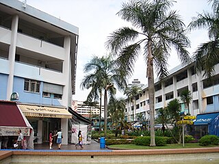
Clementi (;) is a planning area and residential town located at the easternmost fringe of the West Region of Singapore. The town borders Bukit Batok to the north, Bukit Timah to the northeast, Queenstown to the east and Jurong East to the west.

Seongnam is the second largest city in South Korea's Gyeonggi Province after Suwon and the 10th largest city in the country. Its population is approximately one million. Seongnam is a satellite city of Seoul. It is largely a residential city located immediately southeast of Seoul and belongs to the Seoul National Capital Area.

Night service, also known as owl service, is the public transport services operated during the night hours. These services are operated, mainly using buses but in certain cases using trams, either in addition to or in substitution for ordinary daytime services or rapid transit rail services which may shut for maintenance or due to lack of passenger volumes at night in many cities worldwide.

Brampton Transit (BT) is a public transport bus operator for the City of Brampton in the Regional Municipality of Peel, and within the Greater Toronto Area (GTA) in Ontario, Canada. Brampton Transit began operations in 1974.
Durham Region Transit (DRT) is the regional public transit operator in Durham Region, Ontario, Canada, east of Toronto. Its headquarters are at 605 Rossland Rd East in Whitby, Ontario, and there are regional centres in Ajax, Whitby, and Oshawa. It was formed by the merger of Ajax/Pickering Transit, Whitby Transit, Oshawa Transit, and Clarington Transit.

First London was a bus company operating services in east and west Greater London, England. It was a subsidiary of FirstGroup and operated buses under contract to Transport for London. It was formed in the late 1990s through the acquisition of three London bus operators. First London's garages were sold off between December 2007 and June 2013 with the last closing in September 2013.

Bowenpally is a locality in Secunderabad, India. It is predominantly an upper middle class area. It has some of the best residential colonies. It is located on the northwest fringe of Hyderabad city. Bowenpally is part of the Secunderabad Cantonment area, where the British held sway for several years. The old village of Bowenpally with its people-friendly streets still exist. One among the few old structures left is an old shrine with some rough sculptures of a bull with distinct Kakatiyan design, near the Bowenpally Police Station. It is a juncture connecting different parts of the city.

Dhilwan is a town and a nagar panchayat in Kapurthala district in the state of Punjab, India.
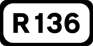
The R136 road is a regional road in Ireland, located in the southwest of Dublin. Named the Outer Ring Road, the route, which is dual carriageway, runs from the N4 at Lucan to the N81 at Tallaght, bypassing west of Clondalkin and crossing the N7 near Citywest. It was built as part of the planning for the new town of Adamstown.
Fulwell Bus Garage is a Transport for London bus garage located in Twickenham in west London. It is north of Fulwell railway station and operates as two halves, with entrances on the A311 Wellington Road and B358 Stanley Road. It is currently operated by Abellio London and London United.

The A2212 road is a 4-digit, non-primary A road in southeast London, England; it is 5.7 km (3.5 mi) long and runs in a north to south direction from Lee Green, to Bromley passing through Grove Park, Downham, Plaistow and Sundridge. Bromley is the only one of these places which is a primary destination.
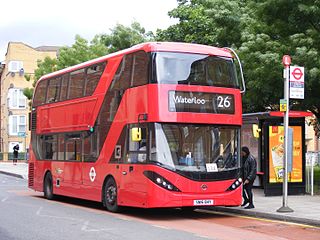
London Buses route 26 is a Transport for London contracted bus route in London, England. Running between Hackney Wick and Waterloo station, it is operated by HCT Group.

The R117 road is a regional road in Ireland. The route (north-south) starts Harcourt Road at the end of the South Circular Road on the southside of Dublin city centre. It crosses the Grand Canal and goes through the suburbs of Ranelagh, Milltown, Windy Arbour, Dundrum, Sandyford, Stepaside and Kilternan before passing through the Scalp into County Wicklow.

The London Night Bus network is a series of night bus routes that serve Greater London. Services broadly operate between the hours of 23:00 and 06:00.

Sun Yuen Long Centre is a private housing estate and shopping centre in Yuen Long, New Territories, Hong Kong, above Light Rail Yuen Long Terminal and next to MTR West Rail Yuen Long Station. Starting on 1 September 2015, the new replacement name is YOHO MALL II when at the same time opened a new shopping mall on the opposite called YOHO MALL I along Castle Peak Road. It consists of five 31-floor high-rise buildings developed in 1993 by Sun Hung Kai Properties and Kowloon-Canton Railway Corporation.
Nine special routes of U.S. Route 82 currently exist. Four of them lie within the state of Arkansas, with four more in Texas, and one in Georgia. Six more existed in the past but have since been decommissioned.

Tower Transit is a Transport for London contracted bus operator operating mainly in west and east London. It is a subsidiary of SeaLink Travel Group.

West Hills is a neighborhood in the Southwest District of Baltimore, located between the neighborhoods of Westgate (south), Franklintown (north) and Hunting Ridge (east). Its boundaries are drawn by the Baltimore County line (west), Baltimore National Pike (south) and North Franklintown Road (north). Its eastern boundary follows Cooks Lane from Baltimore National Pike, then Briarclift Road and finally Wynans Way to the intersection with N. Franklintown Road.