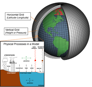
Numerical climate models use quantitative methods to simulate the interactions of the important drivers of climate, including atmosphere, oceans, land surface and ice. They are used for a variety of purposes from study of the dynamics of the climate system to projections of future climate. Climate models may also be qualitative models and also narratives, largely descriptive, of possible futures.

A general circulation model (GCM) is a type of climate model. It employs a mathematical model of the general circulation of a planetary atmosphere or ocean. It uses the Navier–Stokes equations on a rotating sphere with thermodynamic terms for various energy sources. These equations are the basis for computer programs used to simulate the Earth's atmosphere or oceans. Atmospheric and oceanic GCMs are key components along with sea ice and land-surface components.

The Geophysical Fluid Dynamics Laboratory (GFDL) is a laboratory in the National Oceanic and Atmospheric Administration (NOAA) Office of Oceanic and Atmospheric Research (OAR). The current director is Venkatachalam Ramaswamy. It is one of seven Research Laboratories within NOAA's OAR.

The United States National Centers for Environmental Prediction (NCEP) delivers national and global weather, water, climate and space weather guidance, forecasts, warnings and analyses to its Partners and External User Communities. These products and services are based on a service-science legacy and respond to user needs to protect life and property, enhance that nation's economy and support the nation's growing need for environmental information. The centers form part of the National Weather Service.

The Environmental Modeling Center (EMC) is a United States Government agency, which improves numerical weather, marine and climate predictions at the National Centers for Environmental Prediction (NCEP), through a broad program of research in data assimilation and modeling. In support of the NCEP operational forecasting mission, the EMC develops, improves and monitors data assimilation systems and models of the atmosphere, ocean and coupled system, using advanced methods developed internally as well as cooperatively with scientists from universities, NOAA laboratories and other government agencies, and the international scientific community.
GRIB is a concise data format commonly used in meteorology to store historical and forecast weather data. It is standardized by the World Meteorological Organization's Commission for Basic Systems, known under number GRIB FM 92-IX, described in WMO Manual on Codes No.306. Currently there are three versions of GRIB. Version 0 was used to a limited extent by projects such as TOGA, and is no longer in operational use. The first edition is used operationally worldwide by most meteorological centers, for Numerical Weather Prediction output (NWP). A newer generation has been introduced, known as GRIB second edition, and data is slowly changing over to this format. Some of the second-generation GRIB is used for derived products distributed in the Eumetcast of Meteosat Second Generation. Another example is the NAM model.

Oceanic and Atmospheric Research (OAR) is a division of the National Oceanic and Atmospheric Administration (NOAA). OAR is also referred to as NOAA Research.
The Earth System Modeling Framework (ESMF) is open-source software for building climate, numerical weather prediction, data assimilation, and other Earth science software applications. These applications are computationally demanding and usually run on supercomputers. The ESMF is considered a technical layer, integrated into a sophisticated common modeling infrastructure for interoperability. Other aspects of interoperability and shared infrastructure include: common experimental protocols, common analytic methods, common documentation standards for data and data provenance, shared workflow, and shared model components.

The Global Forecast System (GFS) is a global numerical weather prediction system containing a global computer model and variational analysis run by the United States' National Weather Service (NWS).

A tropical cyclone forecast model is a computer program that uses meteorological data to forecast aspects of the future state of tropical cyclones. There are three types of models: statistical, dynamical, or combined statistical-dynamic. Dynamical models utilize powerful supercomputers with sophisticated mathematical modeling software and meteorological data to calculate future weather conditions. Statistical models forecast the evolution of a tropical cyclone in a simpler manner, by extrapolating from historical datasets, and thus can be run quickly on platforms such as personal computers. Statistical-dynamical models use aspects of both types of forecasting. Four primary types of forecasts exist for tropical cyclones: track, intensity, storm surge, and rainfall. Dynamical models were not developed until the 1970s and the 1980s, with earlier efforts focused on the storm surge problem.

Joseph Smagorinsky was an American meteorologist and the first director of the National Oceanic and Atmospheric Administration (NOAA)'s Geophysical Fluid Dynamics Laboratory (GFDL).

In atmospheric science, an atmospheric model is a mathematical model constructed around the full set of primitive, dynamical equations which govern atmospheric motions. It can supplement these equations with parameterizations for turbulent diffusion, radiation, moist processes, heat exchange, soil, vegetation, surface water, the kinematic effects of terrain, and convection. Most atmospheric models are numerical, i.e. they discretize equations of motion. They can predict microscale phenomena such as tornadoes and boundary layer eddies, sub-microscale turbulent flow over buildings, as well as synoptic and global flows. The horizontal domain of a model is either global, covering the entire Earth, or regional (limited-area), covering only part of the Earth. The different types of models run are thermotropic, barotropic, hydrostatic, and nonhydrostatic. Some of the model types make assumptions about the atmosphere which lengthens the time steps used and increases computational speed.

The Weather Research and Forecasting (WRF) Model is a numerical weather prediction (NWP) system designed to serve both atmospheric research and operational forecasting needs. NWP refers to the simulation and prediction of the atmosphere with a computer model, and WRF is a set of software for this. WRF features two dynamical (computational) cores, a data assimilation system, and a software architecture allowing for parallel computation and system extensibility. The model serves a wide range of meteorological applications across scales ranging from meters to thousands of kilometers.
In weather forecasting, model output statistics (MOS) is a multiple linear regression technique in which predictands, often near-surface quantities, are related statistically to one or more predictors. The predictors are typically forecasts from a numerical weather prediction (NWP) model, climatic data, and, if applicable, recent surface observations. Thus, output from NWP models can be transformed by the MOS technique into sensible weather parameters that are familiar to a layperson.

The Hurricane Weather Research and Forecasting (HWRF) model is a specialized version of the weather research and forecasting model and is used to forecast the track and intensity of tropical cyclones. The model was developed by the National Oceanic and Atmospheric Administration (NOAA), the U.S. Naval Research Laboratory, the University of Rhode Island, and Florida State University. It became operational in 2007.
The NCEP/NCAR Reanalysis is an atmospheric reanalysis produced by the National Centers for Environmental Prediction (NCEP) and the National Center for Atmospheric Research (NCAR). It is a continually updated globally gridded data set that represents the state of the Earth's atmosphere, incorporating observations and numerical weather prediction (NWP) model output from 1948 to present.
An atmospheric reanalysis is a meteorological and climate data assimilation project which aims to assimilate historical atmospheric observational data spanning an extended period, using a single consistent assimilation scheme throughout.
The Rapid Refresh is a numerical weather prediction (NWP) model. The model is designed to provide short-range hourly weather forecasts for North America. The Rapid Refresh was officially made operational on 1 May 2012, replacing the Rapid Update Cycle (RUC). The model also serves as the boundary conditions for the higher-resolution High Resolution Rapid Refresh (HRRR) model, that uses a 3 km (1.9 mi) grid spacing on a domain covering the continental United States.
The Climate Forecast System or coupled forecast system (CFS) is a medium to long range numerical weather prediction and a climate model run by the National Centers for Environmental Prediction (NCEP) to bridge weather and climate timescales. Version 2 became operational as CFSv2 in 2011.
Shian-Jiann Lin is a Taiwanese-American atmospheric scientist. He is currently the head of the Weather and Climate Dynamics Division at the Geophysical Fluid Dynamics Laboratory, the lead developer of the GFDL Finite-Volume Cubed-Sphere Dynamical Core (FV3). and a lead developer or key contributor to several weather and climate models developed using FV3.


