
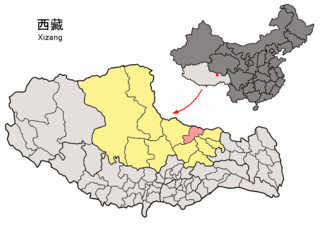
Nagqu is a prefecture-level city in the north of the Chinese autonomous region of Tibet. On May 7, 2018, the former Nagqu Prefecture was officially declared the sixth prefecture-level city in Tibet after Lhasa, Shigatse, Chamdo, Nyingchi and Shannan. The regional area, covering an area of 450,537 km2 (173,953 sq mi), is bordered by Bayingolin and Hotan Prefectures of Xinjiang to the north, Haixi, Yushu Prefectures of Qinghai and Chamdo to the east, Nyingchi, Lhasa and Shigatse to the south, Ngari Prefecture to the west. As of the 2010 census, it had a population of 462,381. Since its official establishment in 2018, it is the largest prefecture-level city by area in the world, being slightly larger than Sweden.
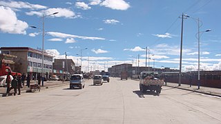
Nagqu, Nagchu in original Tibetan or Naqu, also known as Nagchuka or Nagquka, is a town in northern Tibet, seat of the prefecture-level city of Nagqu, approximately 328 km (204 mi) by road north-east of the capital Lhasa, within the People's Republic of China.
Arza is a small populated town and township, east of Lhasa in the Tibet Autonomous Region of China. It belongs to Lhari County of the Nagqu Prefecture. It also contains solar panels.

Seni District is a district within the Nagqu of the Tibet Autonomous Region, China.

Lhari County is a small county within the prefecture-level city of Nagqu in the Tibet Autonomous Region, China.

Biru County is the most populated county within Nagqu of the Tibet Autonomous Region, China. The name means "female yak". Either of the following pronunciations can be considered correct in Standard Tibetan: [bìru] ~ [pìru] or [ɖìru] ~ [ʈìru].
Nyainrong County is a small county under the administration of the prefecture-level city of Nagqu, in the north of the Tibet Autonomous Region, China, bordering Qinghai province to the north. Yurla is a favourite of the people of the county.

Amdo County is a county within Nagqu of the Tibet Autonomous Region of China. The county covers an area of 43,410.85 square kilometres and is dominated by mainly by Tibetan grassland. In 2000 it had a population of 32,843.

Sog County is a county under the administration of the prefecture-level city of Nagqu of the Tibet Autonomous Region, China.

Baingoin County, formerly Namru Dzong, is a county within Nagqu of the Tibet Autonomous Region, China.

Baqên County is a county within Nagqu of the Tibet Autonomous Region, China. It is located in northeastern Tibet and borders with Qinghai.

Nyima County is the westernmost county-level division under the administration of the prefecture-level city of Nagqu, Tibet Autonomous Region, China. The northern part of the county is within the Changtang area.
Shuanghu County, also transliterated from Tibetan as Tsonyi County or Co Nyi County, is a county under the jurisdiction of the prefecture-level city of Nagqu, in the northernmost part of the Tibet Autonomous Region, China. It was formed in 2012, combining the territory of the former Shuanghu Special District with the eastern half of Nyima County. Much of the county is within the Changtang area.
Baqên Township is a small township in Baqên County within Nagqu Prefecture in the north of the Tibet Autonomous Region of China.
Jiali may refer to the following places in mainland China or Taiwan:
Xainza is a town and township-level administrative unit and seat of Shentsa County or Xainza County, Nagqu Prefecture, Tibet Autonomous Region, China.

Cona, also Cuona Lake or Tsonag Lake, is a major lake of northern Tibet Autonomous Region, China. It is located in Amdo County, Nagqu, west of the road between Nagqu Town and Pana Town. The lake is considered holy to the Tibetans especially in the Bon religion, as it is seen as the "soul lake" of the Razheng Living Buddha. The smaller Ganong Lake lies almost adjacent to the southeast.
Cuoma, or Cuomaxiang is a village and township-level division of Amdo County in the Nagqu Prefecture of the Tibet Autonomous Region, in China. It is located roughly 30 kilometres (19 mi) southwest of Amdo Town near the northern bank of Cona Lake. It covers an area of 5,098 square kilometres (1,968 sq mi) and as of 2004 had a population of about 3,100. Cuoma township of Amdo County has existed since 1960 and was further expanded in 1987, but Cuoma has also been listed under the jurisdiction of Seqing Township of Nyainrong County. The principal economic activity is animal husbandry, pastoral yak, goat, sheep, and so on.
Pana, or Pagnag, also known as Anduo, or Amdo, is a town and the seat of Amdo County in the Nagqu Prefecture of the Tibet Autonomous Region, in China. It lies 464 kilometres north of Lhasa and 138 km north of Nagqu. As of 2004 its jurisdiction had a population of about 2700, 683 of which were living in the town of Pana. The principal economic activity is animal husbandry, pastoral yak, goat, sheep, and so on. Blueschist outcrops are found in the area. The villagers in recent times organized a railway protecting committee to select locals to monitor the Qinghai-Tibet Railway.
"Constructed on the southern side of the Dangla Mountains, Amdo is a Chinese-style town on the Qinghai-Tibet Highway. The road here leads off to the west, heading towards the Mt. Kailash area via the Changthang Plateau. Many of the buses from Golmud to Lhasa used to stay overnight here."