
The Flores Sea covers 240,000 square kilometres (93,000 sq mi) of water in Indonesia. The sea is bounded on the north by the island of Celebes and on the south by Sunda Islands of Flores and Sumbawa.

Area code 951 is a California telephone area code that was split from area code 909 on July 17, 2004. It covers western Riverside County, including the cities and communities of Beaumont, Corona, Canyon Lake, Riverside, Temescal Canyon, Woodcrest, Arlington, Moreno Valley, Perris, Menifee, Lake Elsinore, Wildomar, Murrieta, Temecula, San Jacinto, Hemet, Lakeview, Nuevo, Norco, Banning, Eastvale, Jurupa Valley, and Idyllwild.
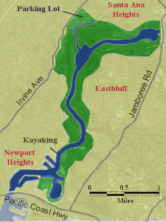
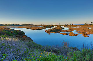
The Upper Newport Bay is a large coastal wetland in Newport Beach, Southern California and a major stopover for birds on the Pacific Flyway. Dozens of species, including endangered ones, can be observed here. Upper Newport Bay Nature Preserve and Ecological Reserve represent approximately 1,000 acres (4 km2) of open space. The Upper Newport Bay was purchased by the state in 1975 for its Fish and Wildlife Department's Ecological Reserve System. In 1985 the upper west bluffs and lands surrounding the bay became part of an Orange County regional park, which offers outdoor activities such as bird-watching, jogging, bicycling, hiking, and kayaking. The Peter and Mary Muth Interpretive Center, located at 2301 University Drive, is open to the public Tuesday through Sunday from 10:00 AM to 4:00 PM. An organization known as the Newport Bay Conservancy (NBC) provides volunteers to answer visitors' questions and guide them through the various activities.
Mount Rungwe is a potentially active volcano in the Mbeya Region of the southern highlands of Tanzania. At an altitude of 2,981 metres (9,780 ft), it is southern Tanzania's second highest peak. Rungwe stands at the junction of the eastern and western arms of the East African Rift. It dominates the mountainous country at the north-west end of the trough that contains Lake Nyasa. The southeastern slopes of these mountains receive up to 3 metres (9.8 ft) of rainfall a year, the highest rainfall in Tanzania. The slopes are covered with a belt of tropical montane forest. Above the treeline, at about 2,600 metres (8,500 ft), there is a belt of heathland. Much of the mountain was listed as a Forest Reserve as early as 1949. The last volcanic eruption probably happened a few hundred years ago.

The Shire of Dumbleyung is a local government area in the Wheatbelt region of Western Australia, about 40 kilometres (25 mi) east of Wagin and about 275 kilometres (171 mi) southeast of Perth, the state capital. The Shire covers an area of 2,540 square kilometres (981 sq mi), and is involved in grain and livestock production and various biodiversity industries including cereals, summer crops, oil mallees, yabbies, emus, poultry and trout. Its seat of government is the town of Dumbleyung.

The Arthur River is located in the south-west of Western Australia. The river was named by Governor James Stirling in October 1835 after Arthur Trimmer, who was a member of the exploring expedition led by Stirling.

Dhoong, part of Narali Union Council, is the second largest village in Gujar Khan Tehsil, Rawalpindi District, Punjab, Pakistan. Dhoong is a historic village of Rawalpindi District and noted for its reserves of oil and natural gas.

The Batiquitos Lagoon is a coastal wetland and estuary located in southern Carlsbad, in the North County region of San Diego County, California.
The Sherlock River is a river in the Pilbara region of Western Australia. It was named on 11 July 1861 by the surveyor and explorer Frank Gregory while on expedition in the area.
San Elijo Lagoon Ecological Reserve is one of the largest remaining coastal wetlands in San Diego County, California, United States.

San Elijo State Beach is a California State Beach in San Diego County, California, United States,
Kot Suleman is small part of village Dhoong near village Trati in Union Council Narali located in Gujar Khan Tehsil, District Rawalpindi, Punjab, Pakistan. Kot Suleman is a historic town of Village Dhoong, Rawalpindi District. Kot Suleman is famous for its natural reserves of oil and natural gas.
Lingbi County is a county in the north of Anhui Province, China, bordering Jiangsu province to the north and northeast. It is under the administration of Suzhou city.
Si County or Sixian is a county in the northeast of Anhui Province, China, bordering Jiangsu province to the north and east. It is under the administration of the prefecture-level city of Suzhou City.

Tijuana River National Estuarine Research Reserve is a natural reserve in Imperial Beach, Californiaand San Ysidro, San Diego. It encompasses the Tijuana River Estuary, located on the Mexico–United States border. It is divided into two parts: the Tijuana Slough National Wildlife Refuge on the north, and Border Field State Park in the south.
Nedrema is a village in Lääneranna Parish, Pärnu County in southwestern Estonia.
The Tijuana River Valley is a rural community in the southern section of San Diego, California. It neighbors Imperial Beach to the north and west, Egger Highlands and Nestor to the north, San Ysidro to the east, and the U.S.-Mexico border to the south. Major thoroughfares include Hollister Street, Monument Road, and Dairy Mart Road.
Laguna Beach State Marine Reserve (SMR) and Laguna Beach State Marine Conservation Area (SMCA) are two adjoining marine protected areas that extend offshore of Laguna Beach in Orange County on California’s south coast. The SMR covers 6.27 square miles, and the SMCA covers an additional 3.44 square miles. These two MPAs are part of a four-MPA complex on the coast of southern Orange County. Each protects marine life by prohibiting or limiting the removal of marine wildlife from within its borders.
Upper Newport Bay State Marine Conservation Area (SMCA) is a marine protected area in Newport Bay in Orange County and the South Coast region of Southern California. It extends inland/northeast from the Pacific Coast Highway crossing of the bay, within the city of Newport Beach.

The 22996 / 95 Ajmer Bandra Terminus Express is a Superfast express train belonging to Indian Railways - North Western Railway zone that runs between Ajmer Junction and Bandra Terminus in India.


