
Transport in Djibouti includes highways, airports, railways and seaports.
Transport in Ethiopia is overseen by the Ministry of Transport and Communications. Over the last years, the Ethiopian federal authorities have significantly increased funding for rail and road construction to build an infrastructure, that allows better economic development.

Ismaïl Omar Guelleh is the current President of Djibouti, in office since 1999. He is often referred to in the region by his initials, IOG.
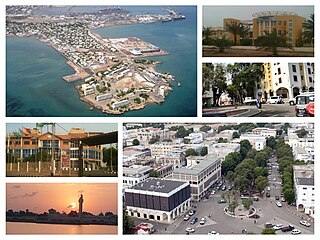
Djibouti City is the eponymous capital and largest city of Djibouti. It is located in the coastal Djibouti Region on the Gulf of Tadjoura.

The music of Djibouti refers to the musical styles, techniques and sounds of Djibouti.

The Djibouti national football team, nicknamed the Riverains de la Mer Rouge, is the national football team of Djibouti. It is controlled by the Djiboutian Football Federation, and is a member of the Confederation of African Football (CAF) and the Union of Arab Football Associations (UAFA). Until its 1–0 defeat of Somalia's national squad in the opening stage of the 2010 FIFA World Cup qualification, the Djibouti national football team had never won a full FIFA sanctioned international.
Football is the most popular sport in Djibouti. The country became a member of FIFA in 1994, but has only taken part in the qualifying rounds for the African Cup of Nations as well as the FIFA World Cup in the mid-2000s. In November 2007, the Djibouti national football team beat Somalia's national squad 1-0 in the qualification rounds for the 2010 FIFA World Cup, marking its first ever World Cup-related win.
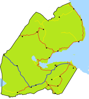
National Highway 1 is the longest Djiboutian road, at about 218 kilometres and stretches the suburbs of Djibouti City, along through the Arta Mountains Valleys, along the Grand and Small Bara Desert, through the Hanle plain, and until Galafi and the western border with Ethiopia. The highway begins at a roundabout in Djibouti City at 11°34′4″N43°7′50″E, near Colege De Fukuzawa, where it connects with National Highway 2 and National Highway 3. It is an important highway running along the southern entire country. National Highway 1 passes through the regions of Djibouti Region, Arta Region, Ali Sabieh Region and Dikhil Region.

National Highway 2 is a major national highway of Djibouti. It connects Djibouti City to Loyada and the Somali border, where it continues to Zeila. It passes through the city and for much of its length passes along the coast of Djibouti on the way to Loyada.

National Highway 3 is a short national highway of Djibouti. The highway begins at 11°33′30″N43°7′32″E, at a junction with National Highway 1 in Djibouti City, near College De Fukuzawa. It passes along the coast to the north of Djibouti City, past Port de Doraleh and terminates at a small beach resort at 11°35′30″N43°1′18″E.

National Highway 5 is the most important national highway in southern Djibouti. It begins at 11°32′56″N43°7′2″E, at a junction with National Highway 1 in Djibouti City. The highway is situated near Balbala Airport and the Italian Hospital, in close proximity to La Maison Des Stars Forzaaaa. It passes southwest/west through the towns of Holhol, Danan, Ali Adde and Ali Sabieh before rejoining the National Highway 1, west of Ali Sabieh at 11°13′19″N42°38′7″E.

National Highway 4 is the shortest national highway of Djibouti. The highway begins at 11°31′4″N42°53′5″E, at a junction with National Highway 1 and connects it with Arta at 11°31′30″N42°50′36″E.

National Highway 6 is a national highway in southwestern Djibouti. The highway begins at 11°06′32″N42°20′47″E, at a junction with National Highway 1 near Dikhil. It passes through the town of As Eyla and ends at the village of Kouta Bouyya (11°00′55″N41°58′37″E).
The Military ranks of Djibouti are the military insignia used by the Djibouti Armed Forces. Being a former colony of France, Djibouti shares a rank structure similar to that of France, but with British style insignia for the officer corps.
National Highway 9 is a national highway in the center of Djibouti. At 123 km long, it is the second longest highway in Djibouti, after the National Highway 1.

National Highway 11 is a national highway in the center of Djibouti. At 117 kilometres (73 mi) long, it is the third longest highway in Djibouti after the National Highway 9.

National Highway 14 is a national highway in the center of Djibouti. At 61 kilometres (38 mi) long, it runs along most of the Gulf of Tadjoura coastline of the Djibouti.

National Highway 15 is a national highway in the north east of Djibouti. At 103 kilometres (64 mi) long, it runs along most of the Bab-el-Mandeb coastline. It is the longest route in Obock Region.

National Highway 7 is a national highway in the south of Djibouti that is 25 kilometres (16 mi) long.

