
Valdez–Cordova Census Area was a census area located in the state of Alaska, United States. As of the 2010 census, the population was 9,636. It was part of the Unorganized Borough and therefore has no borough seat. On January 2, 2019, it was abolished and replaced by the Chugach Census Area and the Copper River Census Area.

Chisana is a census-designated place (CDP) in the Copper River Census Area in the U.S. state of Alaska. As of the 2010 Census, the population of the CDP was 0. The English name Chisana derives from the Ahtna Athabascan name Tsetsaan' Na, meaning literally 'copper river'. The Chisana River joins the Nabesna River just north of Northway Junction, Alaska, to form the Tanana River, a major tributary of the Yukon River. The Chisana Airport consists of a turf and gravel runway which is largely serviced by flights from Tok, Alaska.

Cordova is a city in Chugach Census Area, Alaska, United States. It lies near the mouth of the Copper River, at the head of Orca Inlet on the east side of Prince William Sound. The population was 2,609 at the 2020 census, up from 2,239 in 2010.

Valdez is a city in the Chugach Census Area in the U.S. state of Alaska. According to the 2020 US Census, the population of the city is 3,985, up from 3,976 in 2010. It is the third most populated city in Alaska's Unorganized Borough.
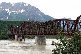
The Miles Glacier Bridge, also known as the Million Dollar Bridge, was built in the early 1900s across the Copper River fifty miles from Cordova in what is now the U.S. state of Alaska. It is a multiple-span Pennsylvania truss bridge which completed a 196-mile (315 km) railroad line for the Copper River and Northwestern Railway, built by J. P. Morgan and the Guggenheim family to haul copper from the old mining town of Kennicott, now located within the Wrangell–St. Elias National Park and Preserve, to the port of Cordova. It earned its nickname because of its $1.4 million cost, well recouped by the about $200 million worth of copper ore which was shipped as a result of its construction.

The Copper River and Northwestern Railway (CR&NW) consisted of two rail lines, the Copper River line and the Northwestern line. Michael James Heney had secured the right-of-way up the Copper River in 1904. He started building the railway from Cordova, Alaska in 1906. The town of Cordova, Alaska, was actually named by Heney on March 13, 1906, based on the original name given by Salvador Fidalgo. Both these railroads were abandoned and little remains of them. Only a 0-4-0 locomotive, "Ole", located near Goose City on a siding of the Alaska Anthracite Railroad Company is the only equipment left. Many of the holdings of the CR&NW railroad including Ole were acquired for this railroad by Mr. Clark Davis and his partners in 1908 after a major storm destroyed the Katalla area facilities in 1907. The town of Cordova would like to move Ole to a memorial site in Cordova to celebrate its role in these railroads. Ole was declared eligible for the National Register of Historic Places in 1988.
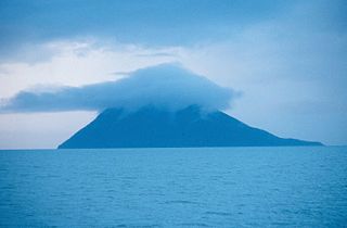
Kayak Island, which includes the Bering Expedition Landing Site, is located in the Gulf of Alaska, 100 km (62 mi) SE of Cordova, Alaska Malaspina Coastal Plain, on the eastern edge of Chugach National Forest. It has a land area of 73.695 km2 (28.454 sq mi) and no population.

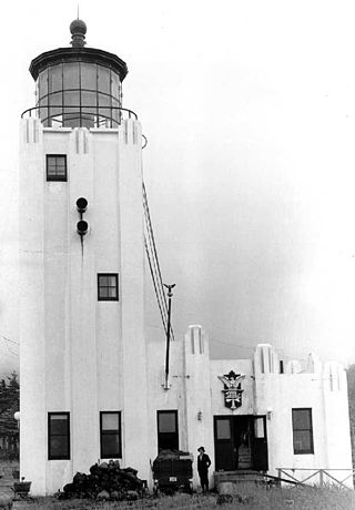
The Cape St. Elias Light is a lighthouse on Kayak Island in Alaska.
The Cape Hinchinbrook Light is a lighthouse located near the southern end of Hinchinbrook Island adjacent to Prince William Sound, in Alaska, United States.
Knight Island is an island in western Prince William Sound of the Gulf of Alaska in the U.S. state of Alaska.
Gulkana can mean the following,
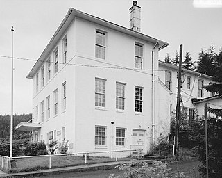
The Cordova Post Office and Courthouse is a historic government building at 612 2nd Street in Cordova, Alaska. It is an L-shaped building, its structure determined in part by the site, which is set into a hill. At the front it is three stories in height and five bays wide, with its main entrance in the leftmost bay, sheltered by a modern solid canopy. The exterior is finished in concrete. The interior originally had the post office on the first floor, a courtroom and judge's chambers on the second floor, and other court offices and a law library on the third floor.

The Slana Roadhouse, on Nabesna Road in Slana, Alaska, in the Valdez-Cordova Census Area, is a historic site dating to 1928. The site was listed on the National Register of Historic Places in 2005. The listing included four contributing buildings on 5 acres (2.0 ha).
The Chistochina Trading Post was a historic roadhouse at mile marker 32 of the Tok Cutoff in the Valdez-Cordova Census Area of southeastern Alaska. It consisted of a connected series of log structures, whose main block is two stories high. The main block, which housed traveler accommodations, is connected to a larger single-story structure, which houses the dining room and bar area. A trading post is believed to have been standing here since as early as 1917; the main lodge was built in 1931.
The Valdez-Trail is an historic early trail in southern Alaska. It is a section of unpaved roadway, eight to ten feet in width, that extends roughly northward from milepost 106.5 of the Richardson Highway, between Copper Center and Glennallen. It is a rare surviving segment of the original Valdez Trail, the first major road built in Alaska, which extends 700 miles (1,100 km) from Valdez into the Alaskan interior. This segment was constructed in 1900 by the Alaska Road Commission, and is now within Wrangell–St. Elias National Park and Preserve. It was listed on the National Register of Historic Places in 1998.

The Red Dragon Historic District encompasses the historic buildings of the St. George's Episcopal mission in Cordova, Alaska. It includes two buildings: the St. George's Episcopal Church, a modest wood-frame structure completed in 1919, and the "Red Dragon" Reading Room, so named because of its traditionally bright red exterior. The Red Dragon was built in 1908, and was the second structure erected in Cordova. It has long served as a social and recreational venue for the Cordova community, and for many years also housed the city's public library.
The Pioneer Igloo Hall Number 19 is a historic social club building at 621 First Street in Cordova, Alaska. It is a log structure, built in 1927–28 to resemble a typical Alaskan trapper's cabin, and occupies a prominent location overlooking the city's downtown. It was built by the local chapter of the Pioneers of Alaska as a meeting space and community hall. The hall has been the subject of restoration and rehabilitation efforts by the local Pioneers, with statewide listing on an endangered structures list in 2012 and 2013.
The Reception Building, once known as the Reception Saloon, is a historic building at the corner of 2nd Street and Browning Avenue in Cordova, Alaska. Set into a hillside, it is a wood-frame structure with two stories at the front and one at the rear. Built in 1908, it is one of the few surviving buildings associated with the early days of the city's development. The Reception Saloon was established by Owen Webster "Link" Wain, a major figure in the economic development of frontier Alaska in the early 20th century, and operated from 1908 until its closure due to Prohibition in 1918.
Chugach Census Area is a census area located in the state of Alaska, United States. It is part of the Unorganized Borough and therefore has no borough seat. On January 2, 2019, it was split from the Valdez–Cordova Census Area, along with neighboring Copper River Census Area.

Copper River Census Area is a census area located in the state of Alaska, United States. It is part of the Unorganized Borough and therefore has no borough seat. On January 2, 2019, it was split from the Valdez–Cordova Census Area, along with neighboring Chugach Census Area.