National Weather Service Minneapolis/Twin Cities, Minnesota

Last updated

National Weather Service Minneapolis/Twin Cities is a weather forecast office responsible for monitoring weather conditions for 51 counties in the states of Minnesota & Wisconsin. [1] The office is in charge of weather forecasts, warnings and local statements as well as aviation weather. It is also equipped with a WSR-88D (NEXRAD) radar, and an Automated Surface Observing System (ASOS) that greatly increase the ability to forecast.

Contents

NOAA Weather Radio

Noaa all hazards.svg

National Weather Service Twin Cities Forecast Office in Chanhassen, Minnesota provides programming for 13 NOAA Weather Radio stations across Central and Southern Minnesota and West Central Wisconsin.

KEC65 Twin Cities

KEC65
Frequency 162.550 MHz
Programming
Language(s) English
Format Weather/Civil Emergency
Technical information
Power 1000 Watts
Links
Webcast Listen Live
Website KEC65

KEC65 broadcasts weather and hazard information for Anoka, Carver, Chisago, Dakota, Goodhue, Hennepin, Ramsey, Rice, Scott, Washington & Wright counties in Minnesota. And Pierce, Polk & St. Croix counties in Wisconsin. [2]

WNG685 Norwood Young America

WNG685
Frequency 162.425 MHz
Programming
Language(s) English
Format Weather/Civil Emergency
Technical information
Power 300 Watts
Links
Website WNG685

WNG685 broadcasts weather and hazard information for Carver, Hennepin, Le Sueur, McLeod, Meeker, Nicollet, Renville, Scott, Sibley & Wright counties in Minnesota. [3]

WNG676 Clearwater

WNG676
Frequency 162.500 MHz
Programming
Language(s) English
Format Weather/Civil Emergency
Technical information
Power 1000 Watts
Links
Webcast Listen Live
Website WNG676

WNG676 broadcasts weather and hazard information for Anoka, Benton, Carver, Hennepin, Isanti, McLeod, Meeker, Mille Lacs, Sherburne, Stearns & Wright counties in Minnesota. [4]

WXL65 St. Cloud

WXL65
Frequency 162.400 MHz
Programming
Language(s) English
Format Weather/Civil Emergency
Technical information
Power 300 Watts
Links
Website WXL65

WXL65 broadcasts weather and hazard information for Benton, Mille Lacs, Morrison, Sherburne & Stearns counties in Minnesota. [5]

KJY80 Red Wing

KJY80
Frequency 162.450 MHz
Programming
Language(s) English
Format Weather/Civil Emergency
Technical information
Power 300 Watts
Links
Website KJY80

KJY80 broadcasts weather and hazard information for Dakota, Goodhue and Wabasha counties in Minnesota, and Buffalo, Pepin, Pierce and St. Croix counties in Wisconsin. [6]

WXK44 Willmar

WXK44
Frequency 162.475 MHz
Programming
Language(s) English
Format Weather/Civil Emergency
Technical information
Power 1000 Watts
Links
Website WXK44

WXK44 broadcasts weather and hazard information for Benton, Chippewa, Kandiyohi, Lac Qui Parle, McLeod, Meeker, Pope, Renville, Stearns, Stevens, Swift, Wright & Yellow Medicine counties in Minnesota. [7]

WNG711 Olivia

WNG711
Frequency 162.400 MHz
Programming
Language(s) English
Format Weather/Civil Emergency
Technical information
Power 300 Watts
Links
Website WNG711

WNG711 broadcasts weather and hazard information for Brown, Chippewa, Kandiyohi, Redwood, Renville & Yellow Medicine counties in Minnesota. [8]

KXI39 New Ulm

KXI39
Frequency 162.525 MHz
Programming
Language(s) English
Format Weather/Civil Emergency
Technical information
Power 1000 Watts
Links
Website KXI39

KXI39 broadcasts weather and hazard information for Blue Earth, Brown, Cottonwood, Faribault, Jackson, Martin, McLeod, Nicollet, Redwood, Renville, Sibley & Watonwan counties in Minnesota. [9]

WXK40 Mankato

WXK40
Frequency 162.400 MHz
Programming
Language(s) English
Format Weather/Civil Emergency
Technical information
Power 1000 Watts
Links
Website WXK40

WXK40 broadcasts weather and hazard information for Blue Earth, Brown, Dodge, Faribault, Freeborn, Le Sueur, Martin, Mower, Nicollet, Rice, Steele, Waseca & Watonwan counties in Minnesota. [10]

WNG673 Long Prairie

WNG673
Frequency 162.525 MHz
Programming
Language(s) English
Format Weather/Civil Emergency
Technical information
Power 1000 Watts
Links
Website WNG673

WNG673 broadcasts weather and hazard information for Cass, Crow Wing, Douglas, Morrison, Otter Tail, Pope, Stearns, Todd & Wadena counties in Minnesota. [11]

WNG707 Kensington

WNG707
Frequency 162.400 MHz
Programming
Language(s) English
Format Weather/Civil Emergency
Technical information
Power 1000 Watts
Links
Website WNG707

WNG707 broadcasts weather and hazard information for Big Stone, Douglas, Grant, Pope, Stevens & Traverse counties in Minnesota. [12]

WNG577 Ladysmith

WNG577
Frequency 162.550 MHz
Programming
Language(s) English
Format Weather/Civil Emergency
Technical information
Power 1000 Watts
Links
Website WNG577

WNG577 broadcasts weather and hazard information for Barron, Chippewa, Price, Rusk, Sawyer, Taylor & Washburn counties in Wisconsin. [13]

WXJ88 Menominee

WXJ88
Frequency 162.400 MHz
Programming
Language(s) English
Format Weather/Civil Emergency
Technical information
Power 1000 Watts
Links
Webcast Listen Live
Website WXJ88

WXJ88 broadcasts weather and hazard information for Barron, Buffalo Chippewa, Dunn Eau Claire, Pepin, Pierce, Polk Rusk, St. Croix & Trempeleau counties in Wisconsin. [14]

Related Research Articles

<span class="mw-page-title-main">Renville County, Minnesota</span> County in Minnesota, United States

Renville County is a county in the U.S. state of Minnesota. As of the 2020 census the population was 14,723. Its county seat is Olivia.

<span class="mw-page-title-main">Meeker County, Minnesota</span> County in Minnesota, United States

Meeker County is a county in the U.S. state of Minnesota. As of the 2020 census, the population was 23,400. Its county seat is Litchfield.

<span class="mw-page-title-main">Kandiyohi County, Minnesota</span> County in Minnesota, United States

Kandiyohi County is a county in the U.S. state of Minnesota. As of the 2020 census, its population is 43,732. As of November 20, 1871, its county seat is Willmar.

<span class="mw-page-title-main">Chippewa County, Minnesota</span> County in Minnesota, United States

Chippewa County is a county in the U.S. state of Minnesota. As of the 2020 census, the population was 12,598. Its county seat is Montevideo. The county was formed in 1862, and was organized in 1868.

<span class="mw-page-title-main">Crow River (Minnesota)</span> River in Minnesota, United States

The Crow River is a tributary of the Mississippi River in south-central Minnesota in the United States. It drains a watershed of 2,756 square miles (7,140 km2).

<span class="mw-page-title-main">National Register of Historic Places listings in Minnesota</span>

This is a list of sites in Minnesota which are included in the National Register of Historic Places. There are more than 1,700 properties and historic districts listed on the NRHP; each of Minnesota's 87 counties has at least 2 listings. Twenty-two sites are also National Historic Landmarks.

Dean Elton Johnson is a former Minnesota politician and a member of the Board of Regents of the University of Minnesota. He is a former member of the Minnesota House of Representatives, and a former member, majority leader and minority leader of the Minnesota Senate.

<span class="mw-page-title-main">2002 Minnesota gubernatorial election</span> Election for the governorship of the U.S. state of Minnesota

The 2002 Minnesota gubernatorial election took place on November 5, 2002 for the post of Governor of Minnesota. Republican candidate Tim Pawlenty defeated Democratic candidate Roger Moe and Independence Party of Minnesota candidate Tim Penny. Due to personal reasons regarding the health of his spouse, incumbent Governor Jesse Ventura chose not to seek re-election. Pawlenty comfortably won the election, which was attributed in part to Moe's uninspired campaign, with Moe being dubbed a "cautious dullard" four years later by the City Pages.

There are many lakes named Mud Lake in the U.S. state of Minnesota, including:

<span class="mw-page-title-main">2000 United States presidential election in Minnesota</span>

The 2000 United States presidential election in Minnesota took place on November 7, 2000, as part of the 2000 United States presidential election, which was held throughout all 50 states and D.C. Voters chose ten representatives, or electors to the Electoral College, who voted for president and vice president.

National Weather Service Chicago, currently based in Romeoville, Illinois, is a weather forecast office responsible for monitoring weather conditions for 23 counties in Northern Illinois, the Chicago metropolitan area and Northwest Indiana. The Army Signal Service established the first federal weather office in the region in Chicago on October 15, 1870. During May 1894 the Chicago Weather Bureau was given a new forecast area extending from the Great Lakes region all the way to the Rocky Mountains. The current National Weather Service Chicago is located in Romeoville and is in charge of issuing local forecasts and weather warnings for the Chicago area. It is one of only two National Weather Service offices in Illinois, the other being National Weather Service Central Illinois in Lincoln, Illinois. The National Weather Service Chicago forecast office is located adjacent to the Lewis University Airport in Romeoville, Illinois.

County roads in Minnesota are roads locally maintained by county highway departments in Minnesota. County roads span a wide variety of road types, varying from A-minor arterials that carry large volumes of traffic to gravel roads.

A wind chill warning is a hazardous weather statement issued by local forecast offices of the National Weather Service (NWS) in the United States and previously by the Meteorological Service of Environment and Climate Change Canada (ECCC) when wind chills are forecast to reach values low enough for residents and travelers to be susceptible to life-threatening medical conditions or death associated with accelerated body heat loss.

<span class="mw-page-title-main">Lac qui Parle Mission</span> United States historic place

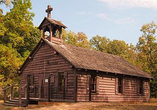
Lac qui Parle Mission is a pre-territorial mission in Chippewa County, Minnesota, United States, which was founded in June 1835 by Dr. Thomas Smith Williamson and Alexander Huggins after fur trader Joseph Renville invited missionaries to the area. Lac qui Parle is a French translation of the native Dakota name, meaning "lake which speaks". In the 19th century, the first dictionary of the Dakota language was written, and part of the Bible was translated into that language for the first time at a mission on the site of the park. It was a site for Christian missionary work to the Sioux for nearly 20 years. Renville was related to and had many friends in the Native community, and after his death in 1846, the mission was taken over by the "irreligious" Martin McLeod. The relationship between the mission and the Dakota people worsened, and in 1854 the missionaries abandoned the site and relocated to the Upper Sioux Agency.

<span class="mw-page-title-main">1996 United States presidential election in Minnesota</span>

The 1996 United States presidential election in Minnesota took place on November 5, 1996, as part of the 1996 United States presidential election. Voters chose ten representatives, or electors to the Electoral College, who voted for president and vice president.

Minnesota Softball is the statewide governing body of amateur softball in Minnesota and an affiliate of USA Softball. As the governing body of softball in Minnesota, it is our responsibility to regulate competition to ensure fairness and equal opportunity to the people who play our sport

National Weather Service Duluth is a weather forecast office responsible for monitoring weather conditions for 18 counties in the states of Minnesota and Wisconsin. The office is in charge of weather forecasts, warnings and local statements as well as aviation weather. It is also equipped with a WSR-88D (NEXRAD) radar, and an Automated Surface Observing System (ASOS) that greatly increase the ability to forecast.

National Weather Service Grand Forks is a weather forecast office responsible for monitoring weather conditions for 35 counties in the US states of North Dakota and Minnesota. The office is in charge of weather forecasts, warnings and local statements as well as aviation weather. It is also equipped with a WSR-88D (NEXRAD) radar, and an Automated Surface Observing System (ASOS) that greatly increase the ability to forecast.

References

  1. "Office Info". National Weather Service Twin Cities. Retrieved 19 July 2023.
  2. KEC65 weather.gov. Accessed July 19, 2023
  3. WNG685 weather.gov. Accessed July 19, 2023
  4. WNG676 weather.gov. Accessed July 19, 2023
  5. WXL65 weather.gov. Accessed July 19, 2023
  6. KJY80 weather.gov. Accessed July 19, 2023
  7. WXK44 weather.gov. Accessed July 20, 2023
  8. WXK44 weather.gov. Accessed July 20, 2023
  9. KXI39 weather.gov. Accessed July 20, 2023
  10. WXK40 weather.gov. Accessed July 20, 2023
  11. WNG673 weather.gov. Accessed July 20, 2023
  12. WNG707 weather.gov. Accessed July 20, 2023
  13. WNG577 weather.gov. Accessed July 20, 2023
  14. WXJ88 weather.gov. Accessed July 20, 2023