Avionics are the electronic systems used on aircraft. Avionic systems include communications, navigation, the display and management of multiple systems, and the hundreds of systems that are fitted to aircraft to perform individual functions. These can be as simple as a searchlight for a police helicopter or as complicated as the tactical system for an airborne early warning platform.

In navigation, dead reckoning is the process of calculating the current position of a moving object by using a previously determined position, or fix, and incorporating estimates of speed, heading, and elapsed time. The corresponding term in biology, to describe the processes by which animals update their estimates of position or heading, is path integration.
Missile guidance refers to a variety of methods of guiding a missile or a guided bomb to its intended target. The missile's target accuracy is a critical factor for its effectiveness. Guidance systems improve missile accuracy by improving its Probability of Guidance (Pg).

Draper Laboratory is an American non-profit research and development organization, headquartered in Cambridge, Massachusetts; its official name is The Charles Stark Draper Laboratory, Inc. The laboratory specializes in the design, development, and deployment of advanced technology solutions to problems in national security, space exploration, health care and energy.

A head-up display, or heads-up display, also known as a HUD or head-up guidance system (HGS), is any transparent display that presents data without requiring users to look away from their usual viewpoints. The origin of the name stems from a pilot being able to view information with the head positioned "up" and looking forward, instead of angled down looking at lower instruments. A HUD also has the advantage that the pilot's eyes do not need to refocus to view the outside after looking at the optically nearer instruments.

LANTIRN is a combined navigation and targeting pod system for use on the United States Air Force fighter aircraft—the F-15E Strike Eagle and F-16 Fighting Falcon manufactured by Martin Marietta. LANTIRN significantly increases the combat effectiveness of these aircraft, allowing them to fly at low altitudes, at night and under-the-weather to attack ground targets with a variety of precision-guided weapons.
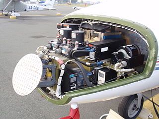
Targeting pods (TGP) are target designation tools used by attack aircraft for identifying targets and guiding precision-guided munition (PGM) such as laser-guided bombs to those targets. The first targeting pods were developed in conjunction with the earliest generation of PGMs in the mid-1960s.

A flight management system (FMS) is a fundamental component of a modern airliner's avionics. An FMS is a specialized computer system that automates a wide variety of in-flight tasks, reducing the workload on the flight crew to the point that modern civilian aircraft no longer carry flight engineers or navigators. A primary function is in-flight management of the flight plan. Using various sensors (such as GPS and INS often backed up by radio navigation) to determine the aircraft's position, the FMS can guide the aircraft along the flight plan. From the cockpit, the FMS is normally controlled through a Control Display Unit (CDU) which incorporates a small screen and keyboard or touchscreen. The FMS sends the flight plan for display to the Electronic Flight Instrument System (EFIS), Navigation Display (ND), or Multifunction Display (MFD). The FMS can be summarised as being a dual system consisting of the Flight Management Computer (FMC), CDU and a cross talk bus.
Terrain contour matching, or TERCOM, is a navigation system used primarily by cruise missiles. It uses a contour map of the terrain that is compared with measurements made during flight by an on-board radar altimeter. A TERCOM system considerably increases the accuracy of a missile compared with inertial navigation systems (INS). The increased accuracy allows a TERCOM-equipped missile to fly closer to obstacles and at generally lower altitudes, making it harder to detect by ground radar.

Acoustic location is a method of determining the position of an object or sound source by using sound waves. Location can take place in gases, liquids, and in solids.

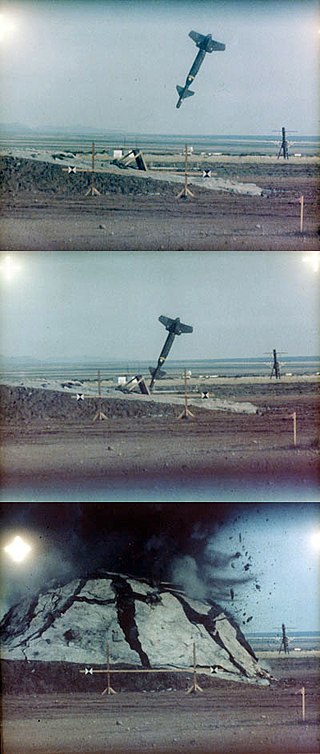
A bombsight is a device used by military aircraft to drop bombs accurately. Bombsights, a feature of combat aircraft since World War I, were first found on purpose-designed bomber aircraft and then moved to fighter-bombers and modern tactical aircraft as those aircraft took up the brunt of the bombing role.
Global Navigation Satellite System (GNSS) receivers, using the GPS, GLONASS, Galileo or BeiDou system, are used in many applications. The first systems were developed in the 20th century, mainly to help military personnel find their way, but location awareness soon found many civilian applications.

Airborne Real-time Cueing Hyperspectral Enhanced Reconnaissance, also known by the acronym ARCHER, is an aerial imaging system that produces ground images far more detailed than plain sight or ordinary aerial photography can. It is the most sophisticated unclassified hyperspectral imaging system available, according to U.S. Government officials. ARCHER can automatically scan detailed imaging for a given signature of the object being sought, for abnormalities in the surrounding area, or for changes from previous recorded spectral signatures.
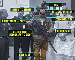
F-INSAS is India's programme to equip its infantry with state-of-the-art equipment, F-INSAS standing for Future Infantry Soldier As a System. However the Indian Army has decided to drop the F-INSAS program in favour of two separate projects. The new program will have two components: one to arm the future infantry soldier with the best available assault rifle, carbines and personal equipment, such as helmets and bulletproof vests. The second component is the Battlefield Management Systems (BMS).
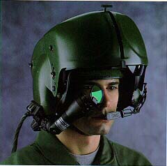
A helmet-mounted display (HMD) is a headworn device that uses displays and optics to project imagery and/or symbology to the eyes. It provides visual information to the user where head protection is required – most notably in military aircraft. The display-optics assembly can be attached to a helmet or integrated into the design of the helmet. An HMD provides the pilot with situation awareness, an enhanced image of the scene, and in military applications cue weapons systems, to the direction their head is pointing. Applications which allow cuing of weapon systems are referred to as helmet-mounted sight and display (HMSD) or helmet-mounted sights (HMS).

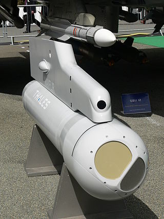
A precision-guided munition (PGM), also called a smart weapon, smart munition, or smart bomb, is a type of weapon system that integrates advanced guidance and control systems, such as GPS, laser guidance, or infrared sensors, with various types of munitions, typically missiles or artillery shells, to allow for high-accuracy strikes against designated targets. PGMs are designed to precisely hit a predetermined target, typically with a margin of error that is far smaller than conventional unguided munitions. Unlike unguided munitions, PGMs use active or passive control mechanisms capable of steering the weapon towards its intended target. PGMs are capable of mid-flight course corrections, allowing them to adjust and hit the intended target even if conditions change. PGMs can be deployed from various platforms, including aircraft, naval ships, ground vehicles, ground-based launchers, and UAVs. PGMs are primarily used in military operations to achieve greater accuracy, particularly in complex or sensitive environments, to reduce the risk to operators, lessen civilian harm, and minimize collateral damage. PGMs are considered an element of modern warfare to reduce unintended damage and civilian casualties. It is widely accepted that PGMs significantly outperform unguided weapons, particularly against fortified or mobile targets.

An inertial navigation system is a navigation device that uses motion sensors (accelerometers), rotation sensors (gyroscopes) and a computer to continuously calculate by dead reckoning the position, the orientation, and the velocity of a moving object without the need for external references. Often the inertial sensors are supplemented by a barometric altimeter and sometimes by magnetic sensors (magnetometers) and/or speed measuring devices. INSs are used on mobile robots and on vehicles such as ships, aircraft, submarines, guided missiles, and spacecraft. Older INS systems generally used an inertial platform as their mounting point to the vehicle and the terms are sometimes considered synonymous.

The LN-3 inertial navigation system is an inertial navigation system (INS) that was developed in the 1960s by Litton Industries. It equipped the Lockheed F-104 Starfighter versions used as strike aircraft in European forces. An inertial navigation system is a system which continually determines the position of a vehicle from measurements made entirely within the vehicle using sensitive instruments. These instruments are accelerometers which detect and measure vehicle accelerations, and gyroscopes which act to hold the accelerometers in proper orientation.

An inertial measurement unit (IMU) is an electronic device that measures and reports a body's specific force, angular rate, and sometimes the orientation of the body, using a combination of accelerometers, gyroscopes, and sometimes magnetometers. When the magnetometer is included, IMUs are referred to as IMMUs.
A synthetic air data system (SADS) is an alternative air data system that can produce synthetic air data quantities without directly measuring the air data. It uses other information such as GPS, wind information, the aircraft's attitude, and aerodynamic properties to estimate or infer the air data quantities. Though air data includes altitude, airspeed, pressures, air temperature, Mach number, and flow angles, existing known SADS primarily focuses on estimating airspeed, Angle of Attack, and Angle of sideslip. SADS is used to monitor the primary air data system if there is an anomaly due to sensor faults or system faults. It can also be potentially used as a backup to provide air data estimates for any aerial vehicle.